Journals >Journal of Geographical Sciences
Contents

2020
Volume: 30 Issue 1
11 Article(s)
Export citation format
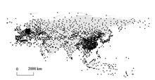
Scenarios of land cover in Eurasia under climate change
Zemeng FAN, Ruyu BAI, and Tianxiang YUE
The method for surface modelling of land cover scenarios (SMLCS) has been improved to simulate the scenarios of land cover in Eurasia. On the basis of the observation monthly climatic data observed from 2127 weather stations in Eurasia during 1981-2010, the climatic scenarios data of RCP26, RCP45 and RCP85 scenarios reThe method for surface modelling of land cover scenarios (SMLCS) has been improved to simulate the scenarios of land cover in Eurasia. On the basis of the observation monthly climatic data observed from 2127 weather stations in Eurasia during 1981-2010, the climatic scenarios data of RCP26, RCP45 and RCP85 scenarios released by CMIP5, and the land cover current data of Eurasia in 2010, the land cover scenarios of Eurasia were respectively simulated. The results show that most land cover types would generally have similar changing trends in the future, but with some difference in different periods under the three scenarios of RCP26, RCP45 and RCP85. Deciduous needleleaf forest, mixed forest, shrub land, wetlands and snow and ice would generally decrease in Eurasia during 2010-2100. Snow and ice would have the fastest decreasing rate that would decrease by 37.42% on average. Shrub land would have the slowest decreasing rate that would decrease by 5.65% on average. Water bodies would have the fastest increasing rate that would increase by 28.78% on average. Barren or sparsely vegetated land would have the slowest increasing rate that would increase by 0.76%. Moreover, the simulated results show that climate change would directly impact on land cover change in Eurasia..
Journal of Geographical Sciences
- Publication Date: Jan. 25, 2020
- Vol. 30, Issue 1, 3 (2020)


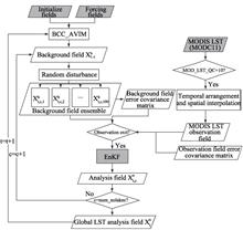
Implications of diurnal variations in land surface temperature to data assimilation using MODIS LST data
Shiwen FU, Suping NIE, Yong LUO, and Xin CHEN
Based on the Beijing Climate Center’s land surface model BCC~~AVIM (Beijing Climate Center Atmosphere-Vegetation Interaction Model), the ensemble Kalman filter (EnKF) algorithm has been used to perform an assimilation experiment on the Moderate Resolution Imaging Spectroradiometer (MODIS) land surface temperature (LST)Based on the Beijing Climate Center’s land surface model BCC_AVIM (Beijing Climate Center Atmosphere-Vegetation Interaction Model), the ensemble Kalman filter (EnKF) algorithm has been used to perform an assimilation experiment on the Moderate Resolution Imaging Spectroradiometer (MODIS) land surface temperature (LST) product to study the influence of satellite LST data frequencies on surface temperature data assimilations. The assimilation results have been independently tested and evaluated by Global Land Data Assimilation System (GLDAS) LST products. The results show that the assimilation scheme can effectively reduce the BCC_AVIM model simulation bias and the assimilation results reflect more reasonable spatial and temporal distributions. Diurnal variation information in the observation data has a significant effect on the assimilation results. Assimilating LST data that contain diurnal variation information can further improve the accuracy of the assimilation analysis. Overall, when assimilation is performed using observation data at 6-hour intervals, a relatively good assimilation result can be obtained, indicated by smaller bias (<2.2K) and root-mean-square-error (RMSE) (<3.7K) and correlation coefficients larger than 0.60. Conversely, the assimilation using 24-hour data generally showed larger bias (>2.2K) and RMSE (>4K). Further analysis showed that the sensitivity of assimilation effect to diurnal variations in LST varies with time and space. The assimilation using observations with a time interval of 3 hours has the smallest bias in Oceania and Africa (both<1K); the use of 24-hour interval observation data for assimilation produces the smallest bias (<2.2K) in March, April and July..
Journal of Geographical Sciences
- Publication Date: Jan. 25, 2020
- Vol. 30, Issue 1, 18 (2020)
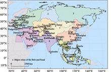
Spatiotemporal variations of aridity index over the Belt and Road region under the 1.5℃ and 2.0℃ warming scenarios
Jian ZHOU, Tong JIANG, Buda Su, Yanjun WANG... and Jianqing ZHAI|Show fewer author(s)
Aridity index reflects the exchanges of energy and water between the land surface and the atmosphere, and its variation can be used to forecast drought and flood patterns, which makes it of great significance for agricultural production. The ratio of potential evapotranspiration and precipitation is applied to analyse Aridity index reflects the exchanges of energy and water between the land surface and the atmosphere, and its variation can be used to forecast drought and flood patterns, which makes it of great significance for agricultural production. The ratio of potential evapotranspiration and precipitation is applied to analyse the spatial and temporal distributions of the aridity index in the Belt and Road region under the 1.5℃ and 2.0℃ global warming scenarios on the basis of outputs from four downscaled global climate models. The results show that: (1) Under the 1.5℃ warming scenario, the area-averaged aridity index will be similar to that in 1986-2005 (around 1.58), but the changes vary spatially. The aridity index will increase by more than 5% in Central-Eastern Europe, north of West Asia, the monsoon region of East Asia and northwest of Southeast Asia, while it is projected to decrease obviously in the southeast of West Asia. Regarding the seasonal scale, spring and winter will be more arid in South Asia, and the monsoon region of East Asia will be slightly drier in summer compared with the reference period. While, West Asia will be wetter in all seasons, except winter. (2) Relative to 1986-2005, both areal averaged annual potential evapotranspiration and precipitation are projected to increase, and the spatial variation of aridity index will become more obvious as well at the 2.0℃ warming level. Although the aridity index over the entire region will be maintained at approximately 1.57 as that in 1.5℃, the index in Central-Eastern Europe, north of West Asia and Central Asia will grow rapidly at a rate of more than 20%, while that in West Siberia, northwest of China, the southern part of South Asia and West Asia will show a declining trend. At the seasonal scale, the increase of the aridity index in Central-Eastern Europe, Central Asia, West Asia, South Asia and the northern part of Siberia in winter will be obvious, and the monsoon region in East Asia will be drier in both summer and autumn. (3) Under the scenario of an additional 0.5℃ increase in global temperature from 1.5℃ to 2.0℃, the aridity index will increase significantly in Central Asia and north of West Asia but decrease in Southeast Asia and Central Siberia. Seasonally, the aridity index in the Belt and Road region will slightly increase in all other seasons except spring. Central Asia will become drier annually at a rate of more than 20%. The aridity index in South Asia will increase in spring and winter, and that in East Asia will increase in autumn and winter. (4) To changes of the aridity index, the attribution of precipitation and potential evapotranspiration will vary regionally. Precipitation will be the major influencing factor over southern West Asia, southern South Asia, Central-Eastern Siberia, the non-monsoon region of East Asia and the border between West Asia and Central Asia, while potential evapotranspiration will exert greater effects over Central-Eastern Europe, West Siberia, Central Asia and the monsoon region of East Asia..
Journal of Geographical Sciences
- Publication Date: Jan. 25, 2020
- Vol. 30, Issue 1, 37 (2020)
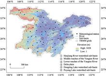
Evaluation of Tropical Rainfall Measuring Mission (TRMM) satellite precipitation products for drought monitoring over the middle and lower reaches of the Yangtze River Basin, China
Shaodan CHEN, Liping ZHANG, Yanjun ZHANG, Mengyao GUO, and Xin LIU
Drought is one of the most frequent and widespread natural disasters and has tremendous agricultural, ecological, societal, and economic impacts. Among the many drought indices, the standardized precipitation index (SPI) based on monthly precipitation data is simple to calculate and has multiscale characteristics. To eDrought is one of the most frequent and widespread natural disasters and has tremendous agricultural, ecological, societal, and economic impacts. Among the many drought indices, the standardized precipitation index (SPI) based on monthly precipitation data is simple to calculate and has multiscale characteristics. To evaluate the applicability of high spatiotemporal resolution satellite precipitation products for drought monitoring, based on the Tropical Rainfall Measuring Mission (TRMM) products and station-based meteorological data, the SPI values at different time scales (1, 3, 6, and 12 months) were calculated for the period of 1998-2016 in the middle and lower reaches of the Yangtze River Basin (MLRYRB). The temporal correlations show that there is a high degree of consistency between calculations at the different time scales (1, 3, 6 and 12 months) based on the two data sources and that the amplitude of fluctuations decreases with increasing time scale. In addition, the Mann-Kendall (MK) test method was applied to analyze the trends from 1998 to 2016, and the results suggest that wetting trends clearly prevailed over drying trends. Moreover, a correlation analysis of the two data sources based on 60 meteorological stations was performed with the SPI values at different time scales. The correlation coefficients at the short time scales (1, 3, and 6 months) are all greater than 0.7, and the correlation coefficient at the long time scale (12 months) is greater than 0.5. In summary, the results demonstrate that the TRMM 3B43 precipitation product provides a new data source that can be used for reliable drought monitoring in the MLRYRB..
Journal of Geographical Sciences
- Publication Date: Jan. 25, 2020
- Vol. 30, Issue 1, 53 (2020)
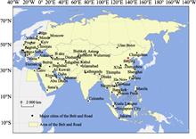
Population, urbanization and economic scenarios over the Belt and Road region under the Shared Socioeconomic Pathways
Cheng JING, Hui TAO, Tong JIANG, Yanjun WANG... and Buda SU|Show fewer author(s)
The countries throughout the Belt and Road region account for more than 60% of the world’s population and half of the global economy. Future changes in this area will have significant influences on the global economic growth, industrial structure and resource allocation. In this study, the proportion of the urban populThe countries throughout the Belt and Road region account for more than 60% of the world’s population and half of the global economy. Future changes in this area will have significant influences on the global economic growth, industrial structure and resource allocation. In this study, the proportion of the urban population to the total population and the gross domestic product were used to represent the levels of urbanization and economic development, respectively. The population, urbanization and economic levels of the Belt and Road countries for 2020-2050 were projected under the framework of the IPCC's shared socioeconomic pathways (SSPs), and the following conclusions are drawn. (1) The population, urbanization and economic levels in the Belt and Road region will likely increase under all five pathways. The population will increase by 2%-8%/10a during 2020-2050 and reach 5.0-6.0 billion in 2050. Meanwhile, the urbanization rate will increase by 1.4%-7.5%/10a and reach 49%-75%. The GDP will increase by 17%-34%/10a and reach 134-243 trillion USD. (2) Large differences will appear under different scenarios. The SSP1 and SSP5 pathways demonstrate relatively high urbanization and economic levels, but the population size is comparatively smaller; SSP3 shows the opposite trend. Meanwhile, the economy develops slowly under SSP4, but it has a relatively high urbanization level, while SSP2 exhibits an intermediate trend. (3) In 2050, the population will increase relative to 2016 in most countries, and population size in the fastest growing country in Central Asia and the Middle East countries will be more than double. Urbanization will develop rapidly in South Asia, West Asia and Central Asia, and will increase by more than 150% in the fastest growing countries. The economy will grow fastest in South Asia, Southeast Asia and West Asia, and increase by more than 10 times in some counties with rapid economic development..
Journal of Geographical Sciences
- Publication Date: Jan. 25, 2020
- Vol. 30, Issue 1, 68 (2020)

Impacts of climate change and LULC change on runoff in the Jinsha River Basin
Qihui CHEN, Hua CHEN, Jun ZHANG, Yukun HOU... and Chongyu XU|Show fewer author(s)
The climate change and Land Use/Land Cover (LULC) change both have an important impact on the rainfall-runoff processes. How to quantitatively distinguish and predict the impacts of the above two factors has been a hot spot and frontier issue in the field of hydrology and water resources. In this research, the SWAT (SoThe climate change and Land Use/Land Cover (LULC) change both have an important impact on the rainfall-runoff processes. How to quantitatively distinguish and predict the impacts of the above two factors has been a hot spot and frontier issue in the field of hydrology and water resources. In this research, the SWAT (Soil and Water Assessment Tool) model was established for the Jinsha River Basin, and the method of scenarios simulation was used to study the runoff response to climate change and LULC change. Furthermore, the climate variables exported from 7 typical General Circulation Models (GCMs) under RCP4.5 and RCP8.5 emission scenarios were bias corrected and input into the SWAT model to predict runoff in 2017-2050. Results showed that: (1) During the past 57 years, the annual average precipitation and temperature in the Jinsha River Basin both increased significantly while the rising trend of runoff was far from obvious. (2) Compared with the significant increase of temperature in the Jinsha River Basin, the LULC change was very small. (3) During the historical period, the LULC change had little effect on the hydrological processes in the basin, and climate change was one of the main factors affecting runoff. (4) In the context of global climate change, the precipitation, temperature and runoff in the Jinsha River Basin will rise in 2017-2050 compared with the historical period. This study provides significant references to the planning and management of large-scale hydroelectric bases at the source of the Yangtze River..
Journal of Geographical Sciences
- Publication Date: Jan. 25, 2020
- Vol. 30, Issue 1, 85 (2020)
Correspondence between the large volcanic eruptions and ENSO events over AD 1525–2000
Xiuqi FANG, Xue ZHENG, and Xing ZHANG
ENSO is an interannual mode which may be affected by external forcing, such as volcanic eruptions. Based on the reconstructed volcanic eruptions chronology and ENSO sequences, both 195 large volcanic eruptions (VEI≥4) and 398 ENSO (El Ni?o and La Ni?a) events were extracted from 1525 to 2000. An analysis of the correspENSO is an interannual mode which may be affected by external forcing, such as volcanic eruptions. Based on the reconstructed volcanic eruptions chronology and ENSO sequences, both 195 large volcanic eruptions (VEI≥4) and 398 ENSO (El Ni?o and La Ni?a) events were extracted from 1525 to 2000. An analysis of the correspondence between the large volcanic eruptions and ENSO events was performed by matching the large volcanic eruptions with the types and magnitudes of ENSO events present in the 0–2 years after the eruptions. The results show the following: (1) The percentages of ENSO events within the 3 years after the large eruptions had increased to 68.3% from 31.7% compared with those with no-eruptions in the previous 0–2 years. In addition, the ratio of El Ni?o to La Ni?a events turned from 2:3 to 1:1, and more El Ni?o events occurred in the 0 year after eruptions in the low-latitudes of the Northern Hemisphere and in the tropics but more La Ni?a events occurred in the 0 year after in the high-latitudes of the Northern Hemisphere and the Southern Hemisphere. (2) After the eruptions, the weak (W) El Ni?o events had increased by 8 percentage points and the very strong (VS) El Ni?o events had decreased by 10 percentage points; conversely, there was a decrease by 15 percentage points of the weak La Ni?a events and an increase by 11.4 percentage points of the very strong La Ni?a events. Specifically, the percentages of strong La Ni?a events increased to a peak at 1 (+1) year after the eruptions. (3) The percentage of eruptions followed by single-year ENSO was the greatest. The percentage of ENSO events that occurred in the consecutive 2 years following an eruption was approximately equal to the percentage of events that occurred consecutively 3 years following an eruption, and both sets of ENSO magnitudes showed a decreasing trend..
Journal of Geographical Sciences
- Publication Date: Jan. 25, 2020
- Vol. 30, Issue 1, 103 (2020)
Multi-scale temperature variations and their regional differences in China during the Medieval Climate Anomaly
Zhixin HAO, Maowei WU, Yang LIU, Xuezhen ZHANG, and Jingyun ZHENG
The Medieval Climate Anomaly (MCA, AD950-1250) is the most recent warm period lasting for several hundred years and is regarded as a reference scenario when studying the impact of and adaptation to global and regional warming. In this study, we investigated the characteristics of temperature variations on decadal-centeThe Medieval Climate Anomaly (MCA, AD950-1250) is the most recent warm period lasting for several hundred years and is regarded as a reference scenario when studying the impact of and adaptation to global and regional warming. In this study, we investigated the characteristics of temperature variations on decadal-centennial scales during the MCA for four regions (Northeast, Northwest, Central-east, and Tibetan Plateau) in China, based on high-resolution temperature reconstructions and related warm-cold records from historical documents. The ensemble empirical mode decomposition method is used to analyze the time series. The results showed that for China as a whole, the longest warm period during the last 2000 years occurred in the 10th-13th centuries, although there were multi-decadal cold intervals in the middle to late 12th century. However, in the beginning and ending decades, warm peaks and phases on the decadal scale of the MCA for different regions were not consistent with each other. On the inter-decadal scale, regional temperature variations were similar from 950 to 1130; moreover, their amplitudes became smaller, and the phases did not agree well from 1130 to 1250. On the multi-decadal to centennial scale, all four regions began to warm in the early 10th century and experienced two cold intervals during the MCA. However, the Northwest and Central-east China were in step with each other while the warm periods in the Northeast China and Tibetan Plateau ended about 40-50 years earlier. On the multi-centennial scale, the mean temperature difference between the MCA and Little Ice Age was significant in Northeast and Central-east China but not in the Northwest China and Tibetan Plateau. Compared to the mean temperature of the 20th century, a comparable warmth in the MCA was found in the Central-east China, but there was a little cooling in Northeast China; meanwhile, there were significantly lower temperatures in Northwest China and Tibetan Plateau..
Journal of Geographical Sciences
- Publication Date: Jan. 25, 2020
- Vol. 30, Issue 1, 119 (2020)
Glacial changes in the Gangdisê Mountains from 1970 to 2016
Juan LIU, Xiaojun YAO, Shiyin LIU, Wanqin GUO, and Junli XU
Based on the revised First Chinese Glacier Inventory (FCGI), the Second Chinese Glacier Inventory (SCGI) and Landsat OLI images for 2015-2016, we analyzed the spatial-temporal variation characteristics of glaciers in the Gangdisê Mountains from 1970 to 2016. The results showed that there were 3953 glaciers with a Based on the revised First Chinese Glacier Inventory (FCGI), the Second Chinese Glacier Inventory (SCGI) and Landsat OLI images for 2015-2016, we analyzed the spatial-temporal variation characteristics of glaciers in the Gangdisê Mountains from 1970 to 2016. The results showed that there were 3953 glaciers with a total area of 1306.45 km 2 and ice volume of ~58.16 km 3 in the Gangdisê Mountains in 2015-2016. Glaciers with sizes of 0.1-5 km 2 and <0.5 km 2 accounted for the largest area and the most amounts of glaciers in the Gangdisê Mountains, respectively. Over the past five decades, the area of glaciers in the Gangdisê Mountains decreased by 854.05 km 2 (-1.09%·a -1), accounting for 39.53% of the total glacier area in 1970. The increase in temperature during the ablation period was the most important cause for glacier retreat. Compared to other mountains in western China, the Gangdisê Mountains have experienced the strongest glacial retreat, and the rate of recession has increased in recent years. The decrease of glacier area was mainly concentrated at elevations of 5600-6100 m, and no change in glacier area was observed at elevations above 6500 m. The number and area of glaciers decreased in all orientations in the Gangdisê Mountains except for south- and southeast-oriented glaciers. Among them, north-oriented glaciers suffered the largest loss of glacier area, while glacier retreat saw the fastest in northwest-oriented glaciers. The rate of glacier retreat increased from west to east in the Gangdisê Mountains. The relative rate of glacier area change was the highest in the eastern section of the Gangdisê Mountains (-1.72%·a -1), followed by the middle section (-1.67%·a -1) and the western section (-0.83%·a -1)..
Journal of Geographical Sciences
- Publication Date: Jan. 25, 2020
- Vol. 30, Issue 1, 131 (2020)
Alternate erosion and deposition in the Yangtze Estuary and the future change
Boyuan ZHU, Yitian LI, Yao YUE, Yunping YANG... and Alistair G. L. BORTHWICK|Show fewer author(s)
The morphological changing trend of the Yangtze Estuary, the largest estuary of Asia, has become a focus of research in recent years. Based on a long series of topographic data from 1950 to 2015, this paper studied the erosion-deposition pattern of the entire Yangtze Estuary. An alternation between erosion and depositiThe morphological changing trend of the Yangtze Estuary, the largest estuary of Asia, has become a focus of research in recent years. Based on a long series of topographic data from 1950 to 2015, this paper studied the erosion-deposition pattern of the entire Yangtze Estuary. An alternation between erosion and deposition was found during the past 65 years, which was in correspondence to the alternation between flood and dry periods identified by multi-year average duration days of high-level water flow (defined as discharge ≥ 60,000 m 3/s, namely, D≥60,000) from the Yangtze River Basin. A quantitative relationship was further developed between the erosional/depositional rate of the Yangtze Estuary and the interpreting variables of yearly water discharge, D≥60,000 and yearly river sediment load, with contributing rates of 1%, 59% and 40%, respectively. Mechanism behind the alternate erosion and deposition pattern was analyzed by examining residual water surface slope and the corresponding capacity of sediment transport in flood and dry periods. In flood periods, a larger discharge results in steeper slope of residual water level which permits a greater capacity of sediment transport. Therefore, more bed materials can be washed to the sea, leading to erosion of the estuary. In contrast, flatter slope of residual water level occurs in dry periods, and deposition dominates the estuarine area due to the decreased capacity of sediment transport and the increased backwater effect of flood-tide. Coastal dynamics and estuarine engineering projects alter the local morphological changes, but slightly affect the total erosional/depositional rate of the whole estuarine region. Heavy sedimentation within the Yangtze Estuary after the impoundment of the Three Gorges Dam can be attributed to the reduced occurrence frequency of flood years due to water regulation by the dam, and largely (at least 36%-52%) sourced from the sea. Deposition is still possible to occur in the Yangtze Estuary in the future, because the multi-year average D≥60,000 is unlikely to exceed the critical value of 14 days/yr which corresponds to the future equilibrium state of the Yangtze Estuary, under the water regulation of the large cascade dams in the upper Yangtze. Nevertheless, the mean depositional rate will not surpass the peak value of the past years, since the total sediment load entering the Yangtze Estuary has presented a decreasing trend..
Journal of Geographical Sciences
- Publication Date: Jan. 25, 2020
- Vol. 30, Issue 1, 145 (2020)
Impacts of climate change and agricultural activities on water quality in the Lower Kaidu River Basin, China
Wulong BA, Pengfei DU, Tie LIU, Anming BAO... and Chengxin QIN|Show fewer author(s)
In the context of climate change and over-exploitation of water resources, water shortage and water pollution in arid regions have become major constraints to local sustainable development. In this study, we established a Soil and Water Assessment Tool (SWAT) model for simulating non-point source (NPS) pollution in theIn the context of climate change and over-exploitation of water resources, water shortage and water pollution in arid regions have become major constraints to local sustainable development. In this study, we established a Soil and Water Assessment Tool (SWAT) model for simulating non-point source (NPS) pollution in the irrigation area of the lower reaches of the Kaidu River Basin, based on spatial and attribute data (2010-2014). Four climate change scenarios (2040-2044) and two agricultural management scenarios were input into the SWAT model to quantify the effects of climate change and agricultural management on solvents and solutes of pollutants in the study area. The simulation results show that compared to the reference period (2010-2014), with a decline in streamflow from the Kaidu River, the average annual irrigation water consumption is expected to decrease by 3.84×10 8 m 3 or 8.87% during the period of 2040-2044. Meanwhile, the average annual total nitrogen (TN) and total phosphorus (TP) in agricultural drainage canals will also increase by 10.50% and 30.06%, respectively. Through the implementation of agricultural management measures, the TN and TP in farmland drainage can be reduced by 14.49% and 16.03%, respectively, reaching 661.56 t and 12.99 t, accordingly, and the increasing water efficiency can save irrigation water consumption by 4.41×10 8 m 3 or 4.77%. The results indicate that although the water environment in the irrigation area in the lower reaches of the Kaidu River Basin is deteriorating, the situation can be improved by implementing appropriate agricultural production methods. The quantitative analysis results of NPS pollutants in the irrigation area under different scenarios provide a scientific basis for water environmental management in the Kaidu River Basin..
Journal of Geographical Sciences
- Publication Date: Jan. 25, 2020
- Vol. 30, Issue 1, 164 (2020)