Wind field is an important parameter characterizing the dynamic characteristics of the earth's atmospheric system, and it serves as basic data necessary for business work and scientific research in fields such as weather forecasting, space weather, and climatology.
The wind field measurement based on satellite remote sensing is not limited by geographical conditions. It can determine the intensity and direction information of the atmospheric wind field at different altitudes by monitoring the motion state of ocean waves, clouds, aerosols, and atmospheric components. It can not only obtain the observation data of ocean, desert, and polar regions, which are difficult to be collected by conventional methods, but also obtain the profile information of the wind field along the height distribution.
As one of the main techniques in atmospheric wind field measurement, passive optical remote sensing has the characteristics of high accuracy, large altitude coverage, and small resource occupation. Great progress in the past half century has been made, and various wind measurement technologies have been developed such as atmospheric motion vectors, infrared hyperspectral analysis of water vapor, wind imaging interferometer, and Doppler modulated gas correlation, which can realize wind field measurement in an altitude ranging from 1 km near the surface to 300-400 km and form a reliable verification and capability complementation with active wind field measurement technologies such as lidar and microwave.
In order to promote the development of spaceborne passive optical remote sensing for measuring atmospheric wind fields, it is necessary to summarize and discuss the existing research progress and future development trends, so as to provide a reference for the development of future passive optical remote sensing detection technology for atmospheric wind field and the task planning in atmospheric wind field detection.
This review focuses on two types of spaceborne optical passive techniques for wind field measurement based on atmospheric motion vector monitoring and atmospheric spectral Doppler shift detection. The fundamental theories, basic inversion methods, and the progress of research and application of representative payloads of various passive wind field detection technologies are summarized (Table 4).
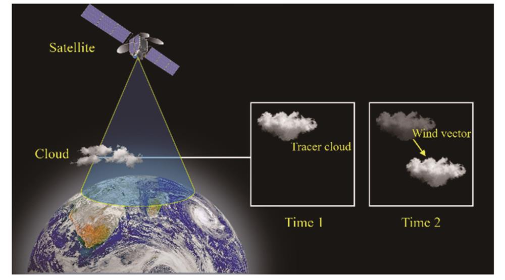
The atmospheric motion vector detection technology relies on cloud map observation to realize wind field detection. It has the characteristics of high spatial resolution and high detection accuracy and can obtain meter-level and precise wind field data at a sub-kilometer scale. However, limited by its detection technology mechanism, its detection altitude and efficiency are also significantly restricted.
Infrared hyperspectral wind field measurement technology is based on infrared images of specific water vapor spectral channels and profile data to track the movement of characteristic image targets at specific altitudes to invert atmospheric wind speed, which is used for troposphere wind measurement, with high vertical resolution and profile data, and it is less affected by the cloud. Compared with those of the cloud-derived motion vector (CMV) technology, its measurement accuracy and horizontal spatial resolution of wind speed and direction need to be improved. However, as infrared hyperspectral loading and wind field inversion algorithms develop, infrared hyperspectral wind field measurement technology will become an important technology for troposphere wind.
The wind field interferometer obtains the interferogram of the fine atmospheric spectrum from the limb observation, inverts the Doppler frequency shift of the atmospheric spectrum through the intensity position or phase change in the interferogram, and then realizes the measurement of the atmospheric wind field. The spaceborne application of this technology began in the late 1960s, and three technical systems have been developed, namely, Michelson interferometer, Fabry-Pérot interferometer, and Doppler asymmetric spatial heterodyne interferometer. The detection altitude covers most of the atmosphere including the stratosphere, mesosphere, and thermosphere. It features continuous profile detection capability, vertical resolution with an order of kilometers, and horizontal spatial resolution with an order of 100 km, and the highest peak accuracy of wind speed measurement has reached 3 m/s.
The Doppler modulated gas correlation technology modulates and filters the incident spectrum through a molecular filter with its composition the same as the target atmospheric composition, so as to realize the frequency shift detection of the atmospheric spectrum and the detection of the wind. Compared with traditional spaceborne wind field measurement technologies, it has the advantages of high horizontal resolution, small size, light weight, and low power consumption and has a good application prospect in the field of small satellite network observation. At present, the technology is still in the stage of technical verification and application testing, and it is expected to further improve the vertical resolution of the limb observation, but the space for improving the effective horizontal resolution is limited.
Through the technical research and payload application in the past 20 to 30 years, China's spaceborne passive optical atmospheric wind field detection technology is gradually narrowing the gap with the international leading level. However, in general, the spaceborne atmospheric wind field detection capability based on passive optical remote sensing still has problems such as discontinuous altitude profile coverage, incomplete local coverage of middle and high level wind field data, and limited spatial resolution of high level wind field data. In the future, the accuracy and resolution of profile data products for tropospheric wind field elements should be improved, and the gaps in China's middle and upper level atmospheric wind field observation data in terms of global scale should be filled. In addition, As China's planetary scientific research and deep-space exploration plans develop, the wind field detection for the atmospheres of Mars, Jupiter, and other planets is also an important direction for the development of wind measurement technology based on passive optical remote sensing.