• Laser & Optoelectronics Progress
  • Vol. 56, Issue 5, 052804 (2019)
Zhongyang Zhao1, Yinglei Cheng1、*, Xiaosong Shi1, Xianxiang Qin1, and Xin Li2
Author Affiliations
  • 1 Information and Navigation College, Air Force Engineering University, Xi'an, Shaanxi 710077, China
  • 2 School of Science, Northeast Electric Power University, Jilin, Jilin 132000, China
  • show less
    DOI: 10.3788/LOP56.052804 Cite this Article Set citation alerts
    Zhongyang Zhao, Yinglei Cheng, Xiaosong Shi, Xianxiang Qin, Xin Li. Terrain Classification of LiDAR Point Cloud Based on Multi-Scale Features and PointNet[J]. Laser & Optoelectronics Progress, 2019, 56(5): 052804 Copy Citation Text show less
    Deep neural network model combining multiscale features with PointNet
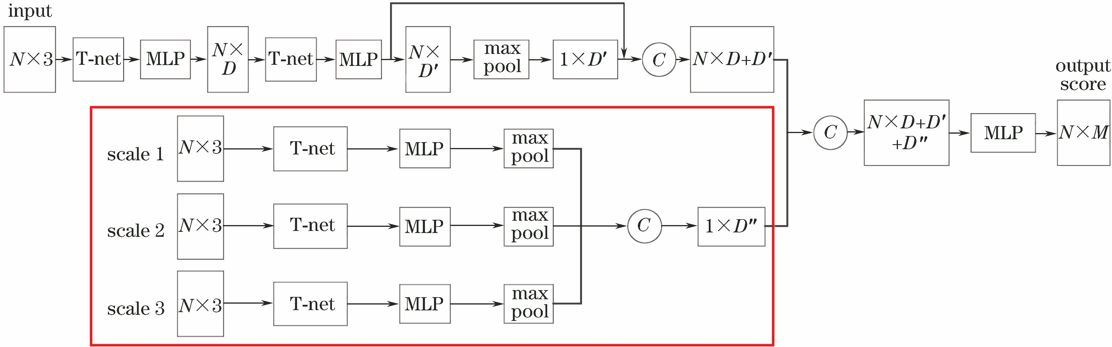
    Fig. 1. Deep neural network model combining multiscale features with PointNet
    PointNet network architecture
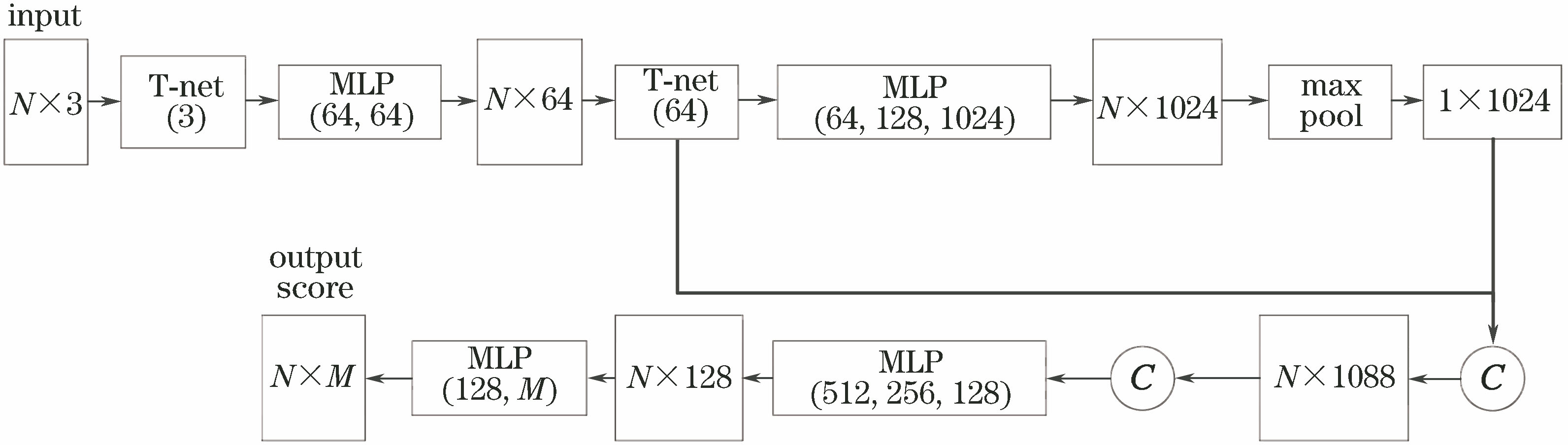
    Fig. 2. PointNet network architecture
    Neighbors of different scales in point clouds. (a) Scale 1; (b) scale 2; (c) scale 3
    Fig. 3. Neighbors of different scales in point clouds. (a) Scale 1; (b) scale 2; (c) scale 3
    Point cloud of Semantic 3D dataset. (a) Area 1; (b) area 2
    Fig. 4. Point cloud of Semantic 3D dataset. (a) Area 1; (b) area 2
    Point cloud of Vaihingen city dataset. (a) Area 1; (b) area 2; (c) area 3
    Fig. 5. Point cloud of Vaihingen city dataset. (a) Area 1; (b) area 2; (c) area 3
    Classification results of Semantic 3D dataset. (a) Input point cloud; (b) PointNet; (c) proposed algorithm
    Fig. 6. Classification results of Semantic 3D dataset. (a) Input point cloud; (b) PointNet; (c) proposed algorithm
    Classification results of Vaihingen city dataset. (a) Input point cloud; (b) PointNet; (c) proposed algorithm
    Fig. 7. Classification results of Vaihingen city dataset. (a) Input point cloud; (b) PointNet; (c) proposed algorithm
    Scales=2s=3s=4
    Multi-scale90.789.889.2
    Scale 185.285.285.2
    Scale 286.487.386.1
    Scale 386.184.984.3
    Table 1. Experimental results of different scales
    AlgorithmMeanIoUMan-madeterrainNaturalterrainHighvegetationLowvegetationBuildingsHardscapeScanningartefactsCars
    Ref. [22]58.585.683.274.232.489.718.525.159.2
    Ref. [23]59.182.077.379.722.991.118.437.364.4
    Ref. [24]61.383.966.086.040.591.130.927.564.3
    Proposed67.485.687.190.542.393.231.640.867.8
    Table 2. Each category IoU of Semantic 3D dataset%
    AlgorithmMeanIoU /%Overallaccuracy /%Runtime /s
    Ref. [22]58.588.9-
    Ref. [23]59.188.63600.00
    Ref. [24]61.388.11881.00
    Proposed67.490.74300.00
    Table 3. Classification accuracy and runtime of Semantic 3D dataset
    AlgorithmMeanIoU /%Power lineCarLowvegetationImpervioussurfacesRoofFence /hedgeFacadeShrubTree
    PointNet32.00.823.232.147.684.72.35.715.476.2
    Proposed34.91.234.336.949.386.82.64.813.385.7
    Table 4. Each category IoU of Vaihingen city dataset%
    AlgorithmMean IoU /%Overall accuracy /%Average class accuracy /%Runtime /s
    PointNet32.065.238.11500.00
    Proposed34.974.343.62300.00
    Table 5. Classification accuracy and runtime of Vaihingen city dataset
    Zhongyang Zhao, Yinglei Cheng, Xiaosong Shi, Xianxiang Qin, Xin Li. Terrain Classification of LiDAR Point Cloud Based on Multi-Scale Features and PointNet[J]. Laser & Optoelectronics Progress, 2019, 56(5): 052804
    Download Citation