• Infrared and Laser Engineering
  • Vol. 50, Issue 6, 20211034 (2021)
Yifan Huang1、2, Yan He1, Shanjiang Hu1, Chunhe Hou1, Xiaolei Zhu1, Kaipeng Li1、2, Fanghua Liu1、2, Yongqiang Chen1、2, and Shouchuan Guo1、2
Author Affiliations
  • 1Key Laboratory of Space Laser Communication and Detection Technology, Shanghai Institute of Optics and Fine Mechanics, Chinese Academy of Sciences, Shanghai 201800, China
  • 2Center of Materials Science and Optoelectronics Engineering, University of Chinese Academy of Sciences, Beijing 100049, China
  • show less
    DOI: 10.3788/IRLA20211034 Cite this Article
    Yifan Huang, Yan He, Shanjiang Hu, Chunhe Hou, Xiaolei Zhu, Kaipeng Li, Fanghua Liu, Yongqiang Chen, Shouchuan Guo. Extracting sea water depth by image processing of ocean lidar[J]. Infrared and Laser Engineering, 2021, 50(6): 20211034 Copy Citation Text show less
    Airborne dual-frequency lidar Mapper 5000 system
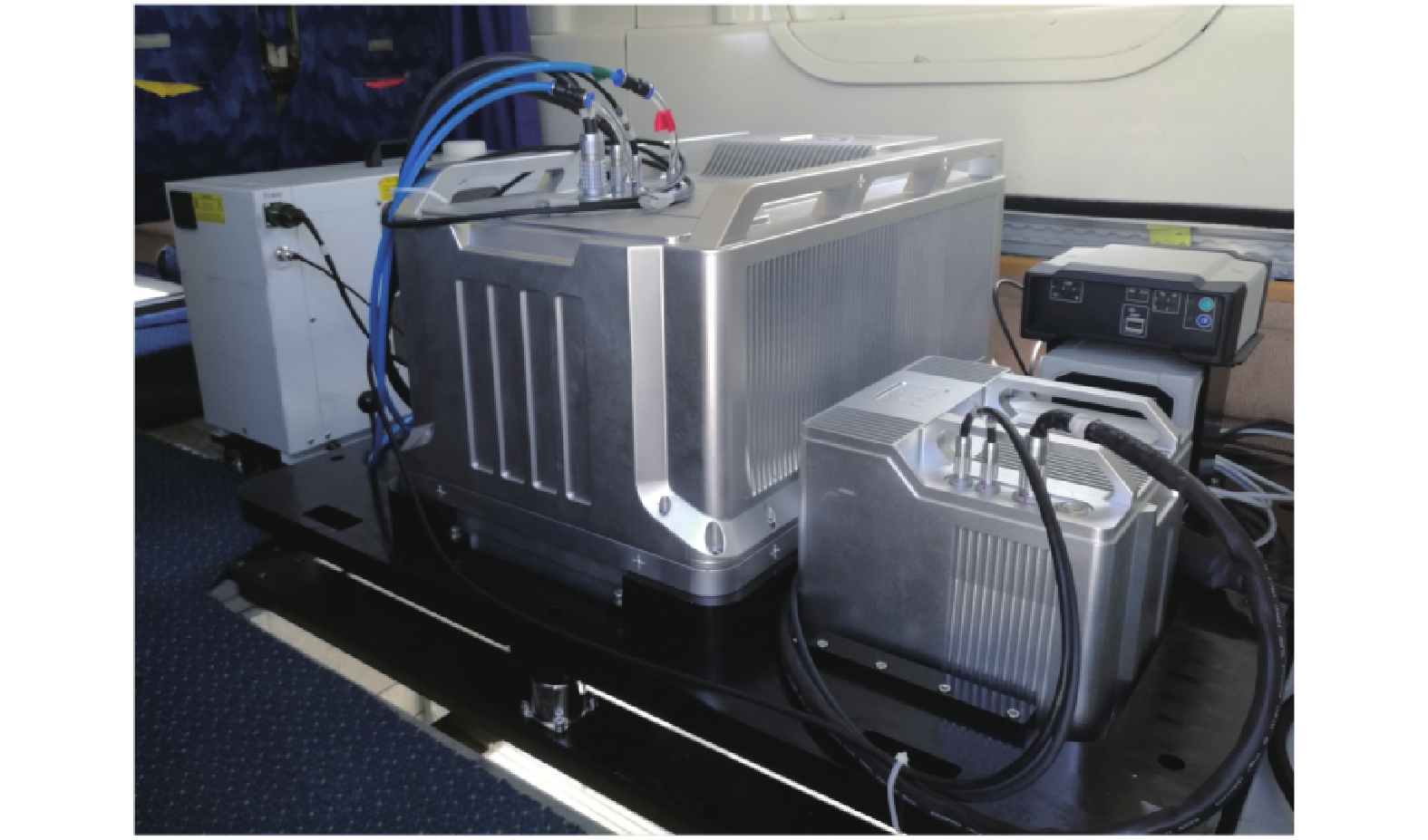
    Fig. 1. Airborne dual-frequency lidar Mapper 5000 system
    Schematic diagram of receiving light path for sub-field of view
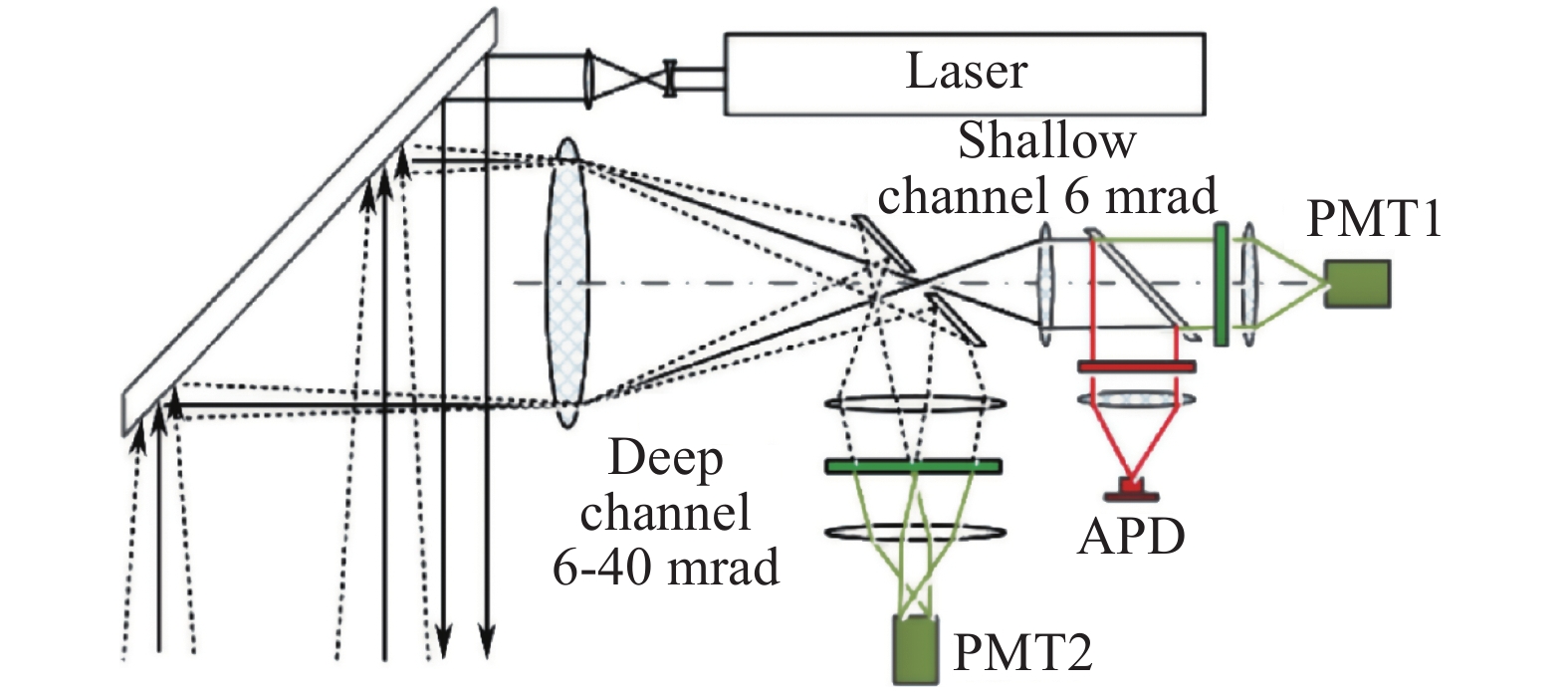
    Fig. 2. Schematic diagram of receiving light path for sub-field of view
    Comparisons of uncorrected base waveform and corrected base waveform. (a) Uncorrected base value waveform comparison; (b) Corrected base value waveform comparison
    Fig. 3. Comparisons of uncorrected base waveform and corrected base waveform. (a) Uncorrected base value waveform comparison; (b) Corrected base value waveform comparison
    Seawater echo energy profile
    Fig. 4. Seawater echo energy profile
    Seawater echo energy profile in the range of 401-600 ns
    Fig. 5. Seawater echo energy profile in the range of 401-600 ns
    Seawater echo energy profile after bilateral filtering
    Fig. 6. Seawater echo energy profile after bilateral filtering
    (a) Seawater echo energy profile after partial thresholding of Niblack; (b) Segmented area corresponds to the seawater echo energy
    Fig. 7. (a) Seawater echo energy profile after partial thresholding of Niblack; (b) Segmented area corresponds to the seawater echo energy
    Seafloor echo profile
    Fig. 8. Seafloor echo profile
    (a) Comparison result of image processing method and waveform processing method; (b) Difference between the image processing slope distance and the waveform processing slope distance
    Fig. 9. (a) Comparison result of image processing method and waveform processing method; (b) Difference between the image processing slope distance and the waveform processing slope distance
    Seafloor echo profile under different motor code numbers
    Fig. 10. Seafloor echo profile under different motor code numbers
    The comparison result of image processing and waveform processing corresponds to the area in Figure 10
    Fig. 11. The comparison result of image processing and waveform processing corresponds to the area in Figure 10
    Image processing and waveform processing slope distance difference corresponds to Figure 10
    Fig. 12. Image processing and waveform processing slope distance difference corresponds to Figure 10
    AreaMethodNumber of seabed echoes detectedMaximum detection slant distance/mMean deviation/m
    Figure10(a)Image processing8253.70200.5162
    Waveform processing6449.1603
    Figure10(b)Image processing6551.58980.4461
    Waveform processing5549.2936
    Figure10(c)Image processing10162.94270.4519
    Waveform processing5650.7347
    Figure10(d)Image processing7158.84120.4045
    Waveform processing2248.6992
    TotalImage processing31962.94270.4547
    Waveform processing19750.7347
    Table 1. The number of seabed echoes and the maximum detection slope distance of different algorithms
    Yifan Huang, Yan He, Shanjiang Hu, Chunhe Hou, Xiaolei Zhu, Kaipeng Li, Fanghua Liu, Yongqiang Chen, Shouchuan Guo. Extracting sea water depth by image processing of ocean lidar[J]. Infrared and Laser Engineering, 2021, 50(6): 20211034
    Download Citation