Author Affiliations
1School of Earth Sciences and Engineering, Nanjing University, Nanjing , Jiangsu 210023, China2School of Computer Science, North China Institute of Science and Technology (National Safety Training Center of Coal Mines), Beijing 101601, Chinashow less
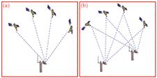
Fig. 1. Positioning mode of GNSS monitoring technology. (a) Absolute positioning; (b) relative positioning
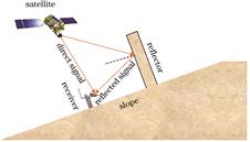
Fig. 2. Multi-effect path schematic
Fig. 3. Deformation rate map obtained by SBAS-InSAR technique
[18] Fig. 4. Schematic diagram of monitoring principle and data remote transmission of monitoring robot
Fig. 5. Schematic diagram of landslide monitoring by three-dimensional laser scanning technique
Fig. 6. Monitoring results of landslide deformation by 3D laser scanning technology
[27] Fig. 7. TDR monitoring system
Fig. 8. TDR monitoring results
[33]. (a) Original data; (b) difference waveforms
Fig. 9. Principle of inclinometer
Fig. 10. Measuring system of MEMS
Fig. 11. Schematic of distributed optical fiber sensing
[41] Fig. 12. Diagram of multi-field action of landslide
[43] Fig. 13. Schematic diagram of monitoring landslide deformation by BOTDA technique
Fig. 14. Internal heating cable and monitoring principle. (a) Structure diagram of cable; (b) schematic of AHFO
Fig. 15. Temperature measuring system of distributed optical fiber and monitoring result. (a) Temperature sensing cable; (b) site measuring; (c) distributed temperature measuring results
| Monitoring method | Principle | Advantage | Disadvantage |
|---|
| GNSS | Location of the monitoring station is obtained in real time by satellite | All-weather and whole-time monitoring | Monitoring station selection freedom is low and data processing is complex | | InSAR | Image of landslide is obtained by using SAR satellite, and then the 3D terrain information of landslide is obtained by processing the image | All-weather and whole-time monitoring; high precision | Monitoring point selection is difficult and affected by space loss correlation and atmospheric delay | | UAV | Unmanned aerial vehicle is equipped with a camera, flies and takes pictures according to the designed route, and gets the 3D model of the slope through image data processing | High precision; automation; intelligent; not affected by the clouds | Affected by weather and not all-weather monitoring |
|
Table 1. Space and air monitoring methods
| Monitoring method | Principle | Advantage | Disadvantage |
|---|
| Robot monitoring | Automatic total station monitors the prisms placed on the landslide in real time | Automatic and whole-time monitoring; high precision | Measuring range of single robot is small, but the cost of multiple measurements is high | | 3D laser scanning | 3D coordinates of the measured object are obtained by measuring the time difference of transmitting and receiving laser and the horizontal angle and zenith distance of each pulse laser | Whole-time, dynamic and initiative monitoring; high precision | Data processing is complex and measuring accuracy is easily affected by surface objects | | GB-InSAR | Ground-based radar sensor moves on the slide track, transmits and receives microwave signals. The synthetic aperture radar technology is used to realize imaging | High precision, all-weather and whole-time monitoring, not affected by weather | Lack of data processing; environment of monitoring can have an impact on results |
|
Table 2. Analysis of main surface monitoring methods
| Monitoring method | Principle | Advantage | Disadvantage |
|---|
| TDR | When the coaxial cable is deformed, the echo signal will be reflected back from the deformation. The position and displacement of the deformation can be obtained by collecting the echo signal and analyzing the waveform | Short monitoring time and low cost; accurate sliding surface positioning | Unable to determine the sliding direction; poor sensitivity to uniform deformation; point-type monitoring | | Borehole inclinometer | The probe of inclinometer has a certain angle with the deformation of rock and soil mass, and then horizontal displacement of the inclinometer probe can be calculated using the angle | Monitoring accurately direction of sliding | Point-type monitoring and orientation are susceptible to interference | | Distributed fiber optic sensing | By receiving and analyzing the scattered light, the changes of strain and temperature along the fiber are obtained | High precision; distributed monitoring; high survival rate; corrosion resistance; anti-interference | Unable to determine the sliding direction |
|
Table 3. Comparison of landslide internal monitoring techniques
| Multi-field monitoring | Distributed optical fiber monitoring technology | Principle | Characteristic |
|---|
| Deformation field | BOTDR/BOTDA technology | By measuring the frequency shift of brillouin scattering light, the strain and temperature changes of corresponding points are obtained according to the relationship between the brillouin frequency shift drift amount and the temperature and strain | It is sensitive to temperature and strain, and the true strain can be obtained by temperature compensation | | Temperature field | ROTDR technology | By measuring the ratio of Stokes light intensity and anti-Stokes light intensity in Raman scattered light, the temperature of each part of the optical fiber is obtained | Precision up to several microstrains and sensitive only to temperature | Seepage field | Actively heating technology based on distributed optical fiber temperature measuring system | Through heating optical cable and DTS measuring, the characteristic value of temperature is determined. Then, soil moisture and seepage rate can be obtained according to the characteristic value of temperature | An artificial temperature field is created near the cable, and then obtaining the seepage field |
|
Table 4. Summary of multi-field monitoring of distributed optical fiber monitoring system