• Laser & Optoelectronics Progress
  • Vol. 57, Issue 20, 202802 (2020)
Hongqiang Bai1、2, Yonghua Xia1、2、*, Minglong Yang1、2、*, Zhaoyong Li3, and De Huang1、2
Author Affiliations
  • 1Faculty of Land Resources Engineering, Kunming University of Science and Technology, Kunming, Yunnan 650093, China
  • 2Surveying & Mapping Technology and Application Research Center on Plateau Mountains of Yunnan Higher Education, Kunming, Yunnan 650093, China;
  • 3Kunming Urban Underground Space Planning and Management Office, Kunming, Yunnan 650011, China
  • show less
    DOI: 10.3788/LOP57.202802 Cite this Article Set citation alerts
    Hongqiang Bai, Yonghua Xia, Minglong Yang, Zhaoyong Li, De Huang. Multi-Resolution 3D Reconstruction of Karst Caves Based on the Feature Line Extraction of 3D Laser Point Cloud[J]. Laser & Optoelectronics Progress, 2020, 57(20): 202802 Copy Citation Text show less
    Schematic diagram of cave accuracy classification. (a) Schematic diagram of karst cave precision division; (b) site photos of facade and ground karst cave; (c) top hanging stalactite site photo; (d) site photo of stalactite raised on the ground
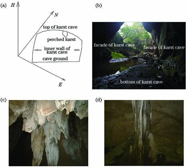
    Fig. 1. Schematic diagram of cave accuracy classification. (a) Schematic diagram of karst cave precision division; (b) site photos of facade and ground karst cave; (c) top hanging stalactite site photo; (d) site photo of stalactite raised on the ground
    Selected model. (a) Original point cloud at the entrance of the cave (model 1); (b) point cloud in the area with rich texture (model 2); (c) point cloud in the area with rich stalactite (model 3)
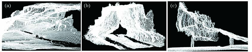
    Fig. 2. Selected model. (a) Original point cloud at the entrance of the cave (model 1); (b) point cloud in the area with rich texture (model 2); (c) point cloud in the area with rich stalactite (model 3)
    Feature line extraction for model 1. (a) Boundary feature value extraction results; (b) point cloud classification results; (c) feature line drawing results
    Fig. 3. Feature line extraction for model 1. (a) Boundary feature value extraction results; (b) point cloud classification results; (c) feature line drawing results
    Feature line extraction for model 1. (a) Boundary feature value extraction results; (b) point cloud classification results; (c) feature line drawing results
    Fig. 4. Feature line extraction for model 1. (a) Boundary feature value extraction results; (b) point cloud classification results; (c) feature line drawing results
    feature line extraction for model 3. (a) Boundary feature value extraction results; (b) point cloud classification results; (c) feature line drawing results
    Fig. 5. feature line extraction for model 3. (a) Boundary feature value extraction results; (b) point cloud classification results; (c) feature line drawing results
    Model 1 after point cloud classification. (a) Triangulation result after point cloud classification; (b) triangulation result without point cloud classification
    Fig. 6. Model 1 after point cloud classification. (a) Triangulation result after point cloud classification; (b) triangulation result without point cloud classification
    Model 2 after point cloud classification. (a) Triangulation result after point cloud classification; (b) triangulation result without point cloud classification
    Fig. 7. Model 2 after point cloud classification. (a) Triangulation result after point cloud classification; (b) triangulation result without point cloud classification
    Model 3 point after cloud classification. (a) Triangulation result after point cloud classification; (b) triangulation result without point cloud classification
    Fig. 8. Model 3 point after cloud classification. (a) Triangulation result after point cloud classification; (b) triangulation result without point cloud classification
    Accuracy gradeDetailed descriptionAbbreviationGrid sampling interval /m
    DInner bottom of caveGround in cave1.00
    CNo special part inthe cave facadeInner wall of karst cave0.50
    BNo special part on the topof the tunnelTop of karst cave0.50
    ASuspended or raised singularpart on the top of the tunnelStalactite and exotic lava0.25
    Table 1. Detailed description of cave accuracy classification
    ModelNumber of triangulargrids with differentresolutionsTime consumedby differentresolutions /sNumber ofD-class resolutiontriangular gridsTime consumedby D-classresolution /sNumber ofA-class resolutiontriangular gridsTime consumedby A-classresolution /s
    11487382577148787569329765871237
    2388255151387146197785426526
    31083624010752252223658154
    Table 2. Comparison of multi-resolution and overall-resolution 3D reconstruction performance
    Hongqiang Bai, Yonghua Xia, Minglong Yang, Zhaoyong Li, De Huang. Multi-Resolution 3D Reconstruction of Karst Caves Based on the Feature Line Extraction of 3D Laser Point Cloud[J]. Laser & Optoelectronics Progress, 2020, 57(20): 202802
    Download Citation