• Laser & Optoelectronics Progress
  • Vol. 58, Issue 8, 0828001 (2021)
Jiahui Wang1, Jili Yao1、*, Xueying Zhao2, Xinzhi Hu1, and Meng Zhao1
Author Affiliations
  • 1School of Architecture Engineering, Shandong University of Technology, Zibo, Shandong 255049, China
  • 2China-Explo TianCheng(Beijing) Technology Co., Ltd., Beijing 100097, China
  • show less
    DOI: 10.3788/LOP202158.0828001 Cite this Article Set citation alerts
    Jiahui Wang, Jili Yao, Xueying Zhao, Xinzhi Hu, Meng Zhao. Point Cloud Georeferencing Based on Fixed Control Primitives of Point, Line, and Surface[J]. Laser & Optoelectronics Progress, 2021, 58(8): 0828001 Copy Citation Text show less
    Point cloud obtained by scanning. (a) S1; (b) S2; (c) S3; (d) S4
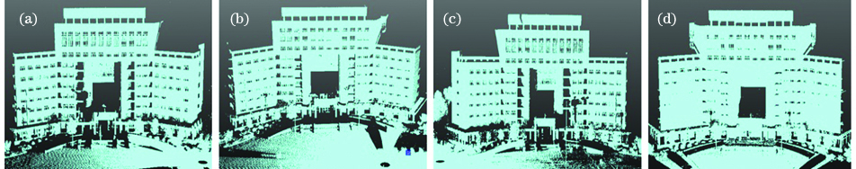
    Fig. 1. Point cloud obtained by scanning. (a) S1; (b) S2; (c) S3; (d) S4
    Errors of two geography methods. (a) Error of the plane point; (b) error of the spatial point
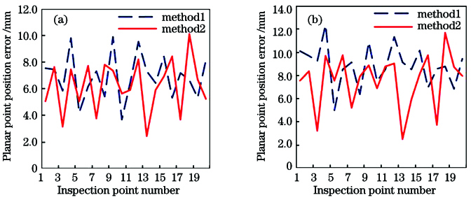
    Fig. 2. Errors of two geography methods. (a) Error of the plane point; (b) error of the spatial point
    Visual effect of the georeferencing point cloud
    Fig. 3. Visual effect of the georeferencing point cloud
    Point numberNorth coordinate /mEast coordinate /mElevation /mPlanar point position error /mmElevation error /mm
    K15495.43868218.033637.22851.360.209
    K25525.70448112.349537.15171.520.315
    K35477.95888189.228137.93801.040.161
    K45368.68248165.123537.22742.070.217
    Table 1. Coordinates and accuracies of ground control points
    Primitive categoryPrimitive numberPrimitive characteristic parameter
    XYZ
    Control pointK1/m5495.43868218.033638.7994
    K2/m5525.70448112.349538.7681
    K3/m5477.95888189.228139.4380
    K4/m5368.68248165.123538.7274
    Control lineL10.001272950.000351200.99999913
    L2-0.002983670.000173430.99999553
    Control planeP10.109080250.99403020-0.00233792
    P2-0.403819740.914833120.00315886
    P30.99387286-0.110521100.00134817
    Table 2. Characteristic parameters of the control primitives in the geographic reference coordinate system
    Scan stationPrimitive numberPrimitive characteristic parameter
    XYZ
    S1K1'/m24.1957-27.3355-0.9703
    K2'/m-36.646064.19492.1386
    K3'/m-3.390658.80662.4820
    L1'0.00291538-0.030293860.99953678
    P2'0.285386580.958061590.02593249
    S2K1'/m39.093298.8350-0.8236
    K2'/m-3.3451-2.58813.7250
    K4'/m-122.957764.80702.482
    L2'0.03001756-0.000747510.99954909
    P1'0.97409640-0.22370053-0.03307980
    S3K2'/m-28.0789-49.9781-0.5254
    K3'/m37.294612.60001.1517
    K4'/m137.1247-37.98071.9611
    L2'-0.014979850.001407230.99988681
    P3'0.354729090.934945240.00668375
    Table 3. Characteristic parameters of the control primitives of each station in the scanning coordinate system
    Scan stationGeographicmethodXS /mYS /mZS /mφ /(°)ω /(°)κ /(°)
    S1method15148.49538520.566538.8158-1.11551.1393220.2606
    method25148.49668520.566038.8134-1.11381.1407220.2577
    S2method15194.81338478.643339.5442-0.01152.1240272.8248
    method25194.80918478.646339.5432-0.01342.1316272.8271
    S3method15167.73858510.958138.8667-0.23300.5101104.6584
    method25167.74128510.960338.8638-0.21140.4851104.6563
    Table 4. Geographical parameters of two geographic methods
    Scan stationGeographicmethodXS /mYS /mZS /mφ /(°)ω /(°)κ /(°)
    S1method13.02.90.40.00860.00050.0036
    method22.62.01.20.00470.00110.0031
    S2method14.13.31.60.00450.00920.0044
    method22.71.82.40.00970.00680.0029
    S3method13.91.30.30.00040.00440.0024
    method21.42.11.10.00750.00030.0015
    Table 5. RMSE of two geography methods
    Jiahui Wang, Jili Yao, Xueying Zhao, Xinzhi Hu, Meng Zhao. Point Cloud Georeferencing Based on Fixed Control Primitives of Point, Line, and Surface[J]. Laser & Optoelectronics Progress, 2021, 58(8): 0828001
    Download Citation