• Journal of Infrared and Millimeter Waves
  • Vol. 41, Issue 2, 493 (2022)
Zhong-Hua HONG1, Peng-Fei SUN1, Ru-Yan ZHOU1, Xiao-Hua TONG2、*, Yong-Jiu FENG2, and Shi-Jie LIU2
Author Affiliations
  • 1The College of Information Technology,Shanghai Ocean University,Shanghai 201306,China
  • 2College of Surveying and Geo-Informatics,Tongji University,Shanghai 200092,China
  • show less
    DOI: 10.11972/j.issn.1001-9014.2022.02.016 Cite this Article
    Zhong-Hua HONG, Peng-Fei SUN, Ru-Yan ZHOU, Xiao-Hua TONG, Yong-Jiu FENG, Shi-Jie LIU. Fast mosaicking method of InSAR-generated multi-stripe digital elevation model[J]. Journal of Infrared and Millimeter Waves, 2022, 41(2): 493 Copy Citation Text show less
    Large-scale multi-stripe digital elevation model(DEM)mosaicking method
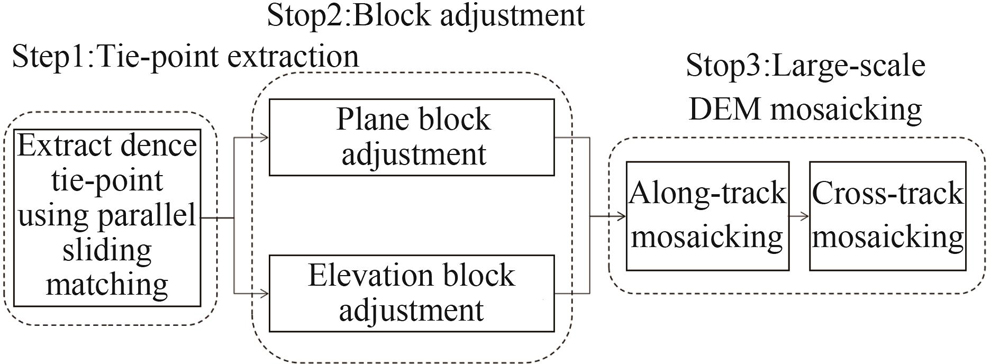
    Fig. 1. Large-scale multi-stripe digital elevation model(DEM)mosaicking method
    Processing flow of digital elevation model(DEM)multi-stripe matching
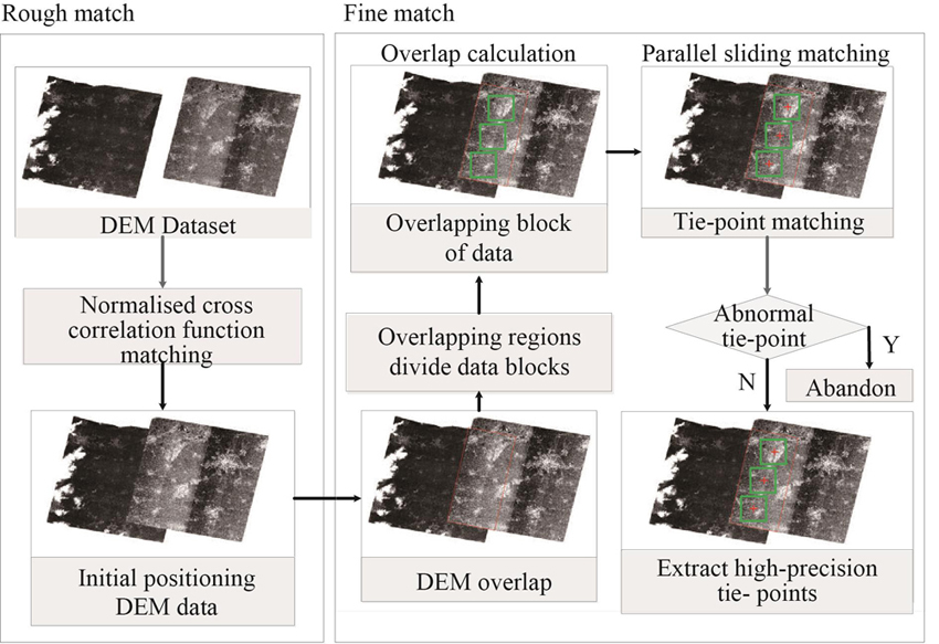
    Fig. 2. Processing flow of digital elevation model(DEM)multi-stripe matching
    Chips partition and sliding matching
    Fig. 3. Chips partition and sliding matching
    Schematic diagram of digital elevation model(DEM)mosaicking strategy
    Fig. 6. Schematic diagram of digital elevation model(DEM)mosaicking strategy
    Collaborative execution process of CPU and GPU after performance optimization
    Fig. 7. Collaborative execution process of CPU and GPU after performance optimization
    Flowchart of CPU parallel computing overlap area
    Fig. 8. Flowchart of CPU parallel computing overlap area
    Tie-point matching flow chart of CPU parallel computing
    Fig. 9. Tie-point matching flow chart of CPU parallel computing
    GPU parallel computing architecture
    Fig. 10. GPU parallel computing architecture
    Slope map of study area.
    Fig. 11. Slope map of study area.
    Distribution of tie-points
    Fig. 12. Distribution of tie-points
    ICESat laser points(red)superimposed on a TanDEM-X grid image
    Fig. 13. ICESat laser points(red)superimposed on a TanDEM-X grid image
    TanDEM-X grid image after block adjustment
    Fig. 14. TanDEM-X grid image after block adjustment
    Large-scale TanDEM-X mosaicking image
    Fig. 15. Large-scale TanDEM-X mosaicking image
    DatasetOrbital numberImage umberImage size(pixels)Resolution(m)Terrain
    TanDEM-X4126588×80208plain
    Table 2. [in Chinese]
    ComparisonTime-consumed /s
    Not using parallel acceleration655.2
    Using parallel acceleration37.59
    Table 3. Comparison of parallel acceleration time
    Residuals between check points and DEM elevationBefore block adjustment/mAfter block adjustment/m
    ABS23.613 5344.014 245
    RMSE3.529 1821.144 294
    MAX90.097 90846.479 540
    MIN9.036 4080.034 023
    Table 4. Comparison of check points and digital elevation model(DEM)elevation residuals before and after adjustment
    ComparisonTime-consumed /s
    Not using parallel acceleration163.7
    Using parallel acceleration18.5
    Table 5. Comparison of resampling parallel acceleration time
    Zhong-Hua HONG, Peng-Fei SUN, Ru-Yan ZHOU, Xiao-Hua TONG, Yong-Jiu FENG, Shi-Jie LIU. Fast mosaicking method of InSAR-generated multi-stripe digital elevation model[J]. Journal of Infrared and Millimeter Waves, 2022, 41(2): 493
    Download Citation