• Spectroscopy and Spectral Analysis
  • Vol. 41, Issue 2, 579 (2021)
Xiang GAO1、1, Yu-ting QI1、1, Bin DONG1、1, Yu-huan CUI1、1, Shuang HAO1、1, Fang ZHAO1、1, and Hong-chang WANG1、1
Author Affiliations
  • 1[in Chinese]
  • 11. School of Science, Anhui Agricultural University, Hefei 230036, China
  • show less
    DOI: 10.3964/j.issn.1000-0593(2021)02-0579-07 Cite this Article
    Xiang GAO, Yu-ting QI, Bin DONG, Yu-huan CUI, Shuang HAO, Fang ZHAO, Hong-chang WANG. Impact of Water Level Fluctuations on Habitats of Wintering Migratory Birds Based on Multispectral Data[J]. Spectroscopy and Spectral Analysis, 2021, 41(2): 579 Copy Citation Text show less
    Location of Shengjin Lake nature reserve
    Fig. 1. Location of Shengjin Lake nature reserve
    Data selection basis(a): Characteristics of water level changes; (b) Corresponding of migratory bird activities and hydrological periods
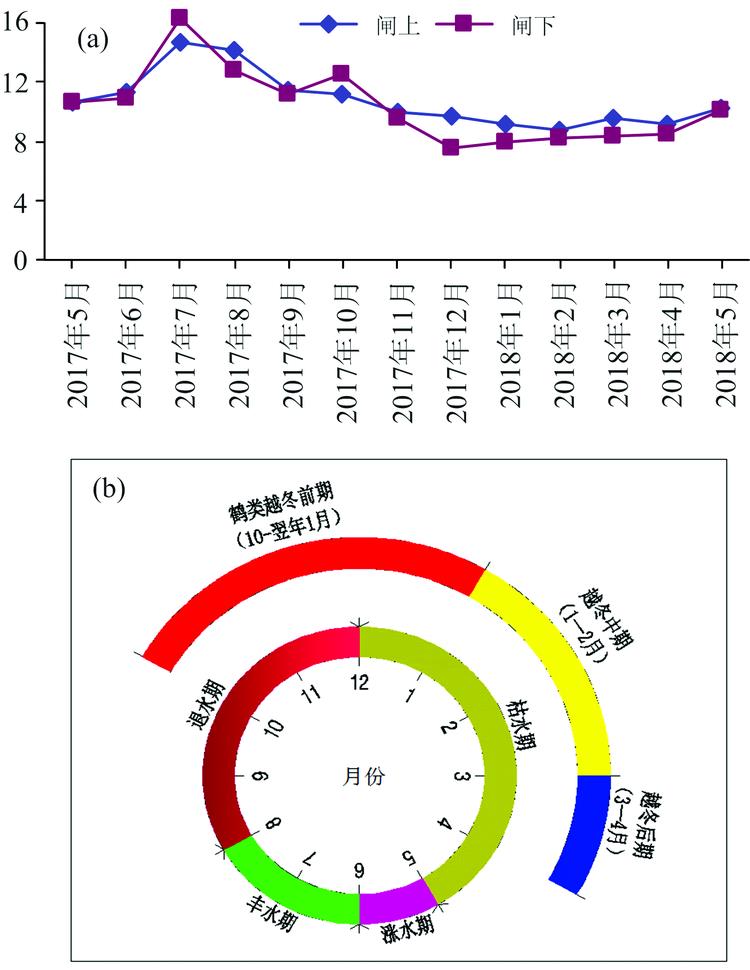
    Fig. 2. Data selection basis
    (a): Characteristics of water level changes; (b) Corresponding of migratory bird activities and hydrological periods
    Classification of land use types in Shengjin Lake wetland
    Fig. 3. Classification of land use types in Shengjin Lake wetland
    Landscape patch spectrum of Shengjin Lake in different hydrological periods
    Fig. 4. Landscape patch spectrum of Shengjin Lake in different hydrological periods
    Variation process of landscape patch areas in different hydrological periods
    Fig. 5. Variation process of landscape patch areas in different hydrological periods
    Trend chart of landscape patch shape index over time
    Fig. 6. Trend chart of landscape patch shape index over time
    Changes of habitat areas in Shengjin Lake in different hydrological periods
    Fig. 7. Changes of habitat areas in Shengjin Lake in different hydrological periods
    日期水文时期
    2017年5月09日涨水期
    2017年7月28日丰水期
    2017年11月1日退水期
    2018年4月10日枯水期
    Table 1. Phase selection of Landsat-8 satellite images
    地类最大似然值法支持向量机
    总数
    /个
    正确分类
    数/个
    制图精度
    /%
    用户精度
    /%
    总数
    /个
    正确分类
    数/个
    制图精度
    /%
    用户精度
    /%
    林地420420100.00100.00420420100.00100.00
    水域1 1291 129100.0097.331 1291 129100.0095.27
    草滩地20820598.56100.00208208100.00100.00
    泥滩地15415399.3588.4415415298.7089.41
    芦苇滩地20820598.56100.0017111768.4279.59
    水田18918899.47100.0018918899.47100.00
    旱地166166100.0098.22166166100.0094.32
    其他用地14011078.5794.027914056.4395.18
    总体精度/%93.048 197.230 2
    Kappa系数0.899 50.960 2
    Table 2. Comparative analysis of two supervised classification methods
    类别面积范围/km2
    A≤15
    B15~100
    C100~500
    D500~2 000
    E>2 000
    Table 3. Classification of landscape patch area
    水文
    时期
    水位
    /m
    斑块数量特征与分级/个
    ABCDE总数/个
    涨水期10.3814 189169287214 395
    丰水期14.339 03519252339 286
    退水期9.7514 088184439114 325
    枯水期8.996 49122860926 790
    Table 4. Quantitative features and classification of patches
    Xiang GAO, Yu-ting QI, Bin DONG, Yu-huan CUI, Shuang HAO, Fang ZHAO, Hong-chang WANG. Impact of Water Level Fluctuations on Habitats of Wintering Migratory Birds Based on Multispectral Data[J]. Spectroscopy and Spectral Analysis, 2021, 41(2): 579
    Download Citation