• Laser & Optoelectronics Progress
  • Vol. 56, Issue 6, 062802 (2019)
Zhenyang Hui1、2, Tieding Lu2、*, Youjian Hu3, Xianyu Yu4, and Yuanping Xia2、5
Author Affiliations
  • 1 Key Laboratory for Digital Land and Resources of Jiangxi Province, East China University of Technology, Nanchang, Jiangxi 330013, China
  • 2 Faculty of Geomatics, East China University of Technology, Nanchang, Jiangxi 330013, China
  • 3 Faculty of Information Engineering, China University of Geosciences, Wuhan, Hubei 430074, China
  • 4 School of Civil Engineering, Architecture and Environment, Hubei University of Technology, Wuhan, Hubei 430068, China
  • 5 Key Laboratory of Watershed Ecology and Geographical Environment Monitoring, Nanchang, Jiangxi 330013, China
  • show less
    DOI: 10.3788/LOP56.062802 Cite this Article Set citation alerts
    Zhenyang Hui, Tieding Lu, Youjian Hu, Xianyu Yu, Yuanping Xia. Airborne LiDAR Point Cloud Filtering Algorithm Based on Dynamic Threshold[J]. Laser & Optoelectronics Progress, 2019, 56(6): 062802 Copy Citation Text show less
    Flow chart of proposed algorithm
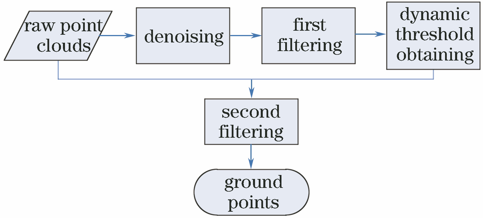
    Fig. 1. Flow chart of proposed algorithm
    Flow chart of second filtering algorithm
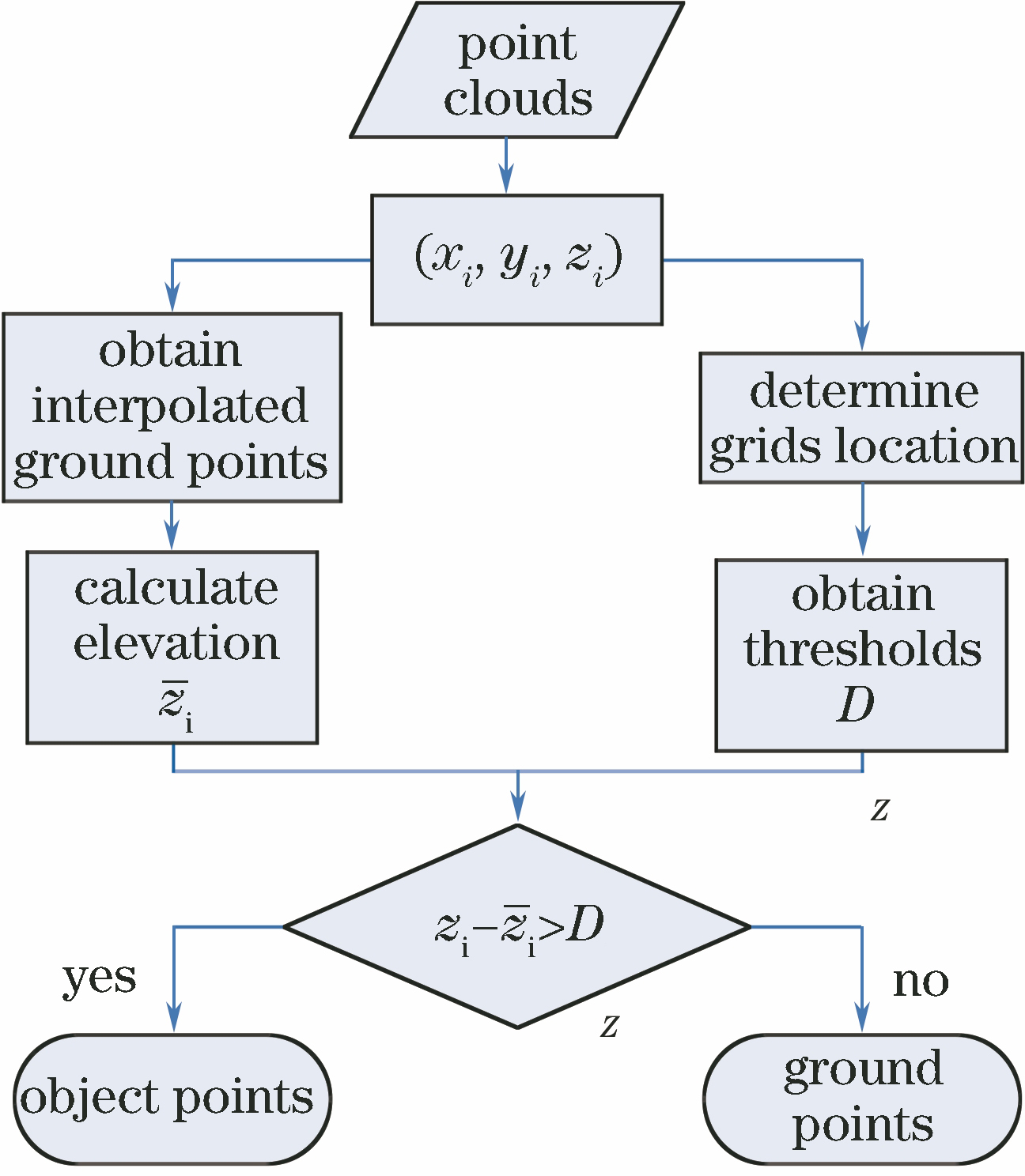
    Fig. 2. Flow chart of second filtering algorithm
    Three-dimensional image of original point cloud
    Fig. 3. Three-dimensional image of original point cloud
    Ground point cloud after first filtering
    Fig. 4. Ground point cloud after first filtering
    Ground point cloud after second filtering
    Fig. 5. Ground point cloud after second filtering
    Three-dimensional surfaces of point cloud. (a) Before filtering; (b) after filtering
    Fig. 6. Three-dimensional surfaces of point cloud. (a) Before filtering; (b) after filtering
    Qualitative analysis of filtering results. (a) Digital surface model of original point cloud; (b) digital elevation model of true groud points; (c) digital elevation model after filtering by proposed algorithm; (d) error distribution of point cloud
    Fig. 7. Qualitative analysis of filtering results. (a) Digital surface model of original point cloud; (b) digital elevation model of true groud points; (c) digital elevation model after filtering by proposed algorithm; (d) error distribution of point cloud
    Error typeTypeⅠerrorTypeⅡerrorTotal error
    First filtering32.916.2921.56
    Second filtering15.1512.8614.23
    Table 1. Accuracy assessment of filtering%
    Filtering algorithmElmqvistSohnAxelssonPfeiferBrocelliRoggeroWackSitholeProposed method
    Type Ⅰ error33.6320.4915.9628.2662.0033.1639.1237.6915.25
    Type Ⅱ error4.3812.173.652.412.533.883.383.4912.86
    Total error22.4020.4910.7617.3536.9620.8024.0223.2514.23
    Table 2. Accuracy comparison among filtering algorithms%
    SampleTerraScanProposed method
    TypeⅠerrorTypeⅡerrorTotal errorTypeⅠerrorTypeⅡerrorTotal error
    1221.491.1211.557.577.217.39
    2114.301.9511.568.136.157.70
    2214.512.5610.782.2317.026.80
    2312.922.548.014.5517.3310.60
    2416.383.9812.977.2919.7810.68
    318.368.974.857.0714.6110.53
    4125.100.7413.1514.7516.0815.42
    428.001.392.559.374.786.12
    510.410.291.130.4918.924.48
    524.724.525.384.3321.916.22
    533.6211.014.027.0018.029.44
    542.4913.682.304.4310.997.91
    611.604.811.713.417.214.54
    711.693.561.903.9110.267.07
    Table 3. Error comparison of filtering results%
    Zhenyang Hui, Tieding Lu, Youjian Hu, Xianyu Yu, Yuanping Xia. Airborne LiDAR Point Cloud Filtering Algorithm Based on Dynamic Threshold[J]. Laser & Optoelectronics Progress, 2019, 56(6): 062802
    Download Citation