• Laser & Optoelectronics Progress
  • Vol. 58, Issue 16, 1628003 (2021)
Xiaobin Li*, Zuhong Liang, Yong Li, Qi Xiao, and You Zhou
Author Affiliations
  • Jiangmen Power Supply Bureau of Guangdong Power Grid Co., Ltd, Jiangmen, Guangdong 529000, China
  • show less
    DOI: 10.3788/LOP202158.1628003 Cite this Article Set citation alerts
    Xiaobin Li, Zuhong Liang, Yong Li, Qi Xiao, You Zhou. Tilt Photography and Lidar Three-Dimensional Scanning for Route Spatial Relationship Detection[J]. Laser & Optoelectronics Progress, 2021, 58(16): 1628003 Copy Citation Text show less
    Flow chart of the data fusion
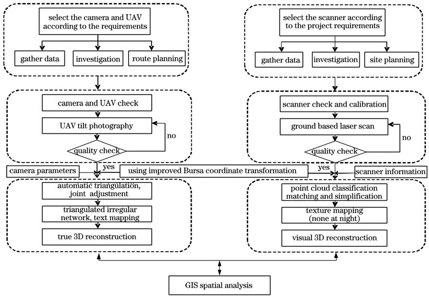
    Fig. 1. Flow chart of the data fusion
    Residual error of the coordinate transformation point
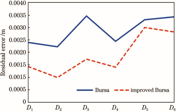
    Fig. 2. Residual error of the coordinate transformation point
    Scanning result of the point cloud. (a) Point cloud 1; (b) point cloud 2
    Fig. 3. Scanning result of the point cloud. (a) Point cloud 1; (b) point cloud 2
    True 3D model based on tilt photography
    Fig. 4. True 3D model based on tilt photography
    True 3D model based on laser point cloud and tilt photography
    Fig. 5. True 3D model based on laser point cloud and tilt photography
    Spatial relationship of the route
    Fig. 6. Spatial relationship of the route
    Measured spatial relationship of the route
    Fig. 7. Measured spatial relationship of the route
    No.Ground truthCalculated valueDifference value
    xyhxyhDxDyDhDifferenceAlgorithm
    D124060.02137224.32422.44324060.02037224.32222.4440.0010.002-0.0010.00240Bursa
    24060.02137224.32322.444-0.00020.001-0.0010.00143improved
    D224823.90447866.5575.83324823.90447866.5565.83100.0010.0020.00224Bursa
    24823.90447866.5575.832000.0010.00100improved
    D326115.76656014.5707.75026115.76856014.5727.752-0.002-0.002-0.0020.00346Bursa
    26115.76756014.5717.751-0.001-0.001-0.0010.00173improved
    D426349.92840731.9823.89926349.92640731.9833.9000.002-0.001-0.0010.00245Bursa
    26349.92840731.9813.90000.001-0.0010.00141improved
    D528106.62728881.9543.68628106.62628881.9573.6850.001-0.0030.0010.00332Bursa
    28106.62628881.9523.6840.0010.0020.0020.00300improved
    D629318.77536961.7223.58029318.77736961.7233.577-0.002-0.0010.0030.00343Bursa
    29318.77536961.7203.58200.002-0.0020.00283improved
    Table 1. Residual table of the improved algorithm unit: m
    No.Calculated valueSurveyed valueDifference value
    xyhxyhDxDyDh
    P132659.7162922.24266.61632659.70862922.24766.605-0.0020.005-0.011
    P242807.80464663.30872.89142807.79964663.30672.869-0.005-0.003-0.022
    P344881.18385990.46757.70544881.19085990.45057.7240.007-0.0170.019
    P449879.34654628.68552.89749879.32654628.67952.895-0.019-0.006-0.002
    P551569.38168903.33555.26551569.36568903.34355.263-0.0160.008-0.002
    P652650.0672017.47253.66852650.04872017.47153.656-0.0120-0.012
    P754060.02157224.32472.44354060.00857224.31072.452-0.013-0.0140.009
    P856349.92860731.98253.89956349.92360731.96453.913-0.005-0.0180.013
    P958106.62748881.95453.68658106.63048881.96353.6850.0030.009-0.001
    P1059318.77556961.72253.58059318.76756961.73553.588-0.0080.0130.008
    Table 2. Precision of the field survey unit: m
    Xiaobin Li, Zuhong Liang, Yong Li, Qi Xiao, You Zhou. Tilt Photography and Lidar Three-Dimensional Scanning for Route Spatial Relationship Detection[J]. Laser & Optoelectronics Progress, 2021, 58(16): 1628003
    Download Citation