As one of the spaceborne detection schemes with the strongest comprehensive aerosol capability at this stage, the polarization crossfire (PCF) strategy is developed in China. It is composed of the particulate observing scanning polarimeter (POSP) and the directional polarimetric camera (DPC) and has been carried by China's Gaofen 5-02 and the Chinese Atmospheric Environmental Monitoring Satellite (DQ-1), which are launched in 2021 and 2022, respectively. To explore the detection ability of the POSP based on PCF in the ultraviolet (UV) band for aerosol layer height (ALH), we study the sensitivity of ALH with the synthetic data in the UV and near-UV bands and further assess the impact of different conditions on the information content and posterior error of ALH. It is expected that our findings can be helpful for the retrieval algorithm development of ALH.
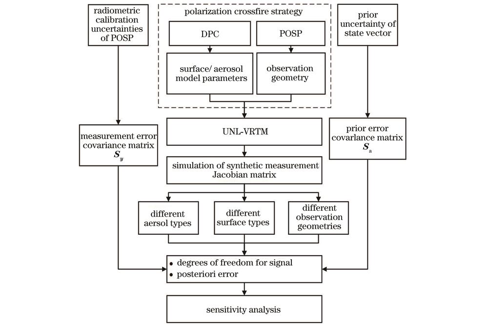
Optimal estimation (OE) theory and information content analysis are employed in this study. OE provides statistical indicators such as the averaging kernel matrix and the degree of freedom for signal (DFS), which can represent how much information on the retrieved parameters we can obtain from the satellite measurements. Therefore, combined with the forward modeling of specific satellite sensor observations, information content analysis is used to provide support for satellite sensor design and retrieval algorithm development. The advantage is that the retrieval capability can be quantified without the development of true inversion. Additionally, it provides top-level physics-based guidance on algorithm design. Firstly, the unified linearized vector radiative transfer model (UNL-VRTM) is used as the forward model to calculate the normalized radiance and polarized radiance at the top of the atmosphere (TOA), as well as the Jacobians of TOA results with respect to corresponding parameters. Then, the DFS and posterior error are introduced to quantify the information content of ALH from the aspects of the intensity and polarization measurements, respectively. Under the assumption of different surface types, aerosol models, and different typical observation geometry cases, the sensitivity analysis results for different situations can be finally obtained.
We analyze the sensitivity variation of ALH with the scattering angle at the solar zenith angle of 40°. The results show that a smaller scattering angle (within 90° to 140°) of the satellite observation geometry is accompanied by higher sensitivity of Stokes parameter I to scale height H (Fig. 10). After that, we choose a fixed observation geometry to calculate the DFS under different schemes. The research shows that the DFS of the bare soil is lower than that of the vegetation surface in the band of 380 nm (Table 6). Generally, the surface reflectance has more impact on the information content of H in terms of POSP measurements than aerosol optical properties, which leads to the lowest information content over bare soil. Meanwhile, with the addition of multi-band measurements and constraints of polarization information, the DFS of ALH is significantly improved (Fig. 11). Different cases indicate that the addition of intensity and polarization measurements for the retrieval of ALH at 380 nm and 410 nm can improve the H information effectively, and the posterior error of the ALH retrieval is also reduced by 5-30 percentage points (Fig. 13). It is shown that the polarization measurement in the UV band has a good constraining effect on the posterior error of H. In addition, with the addition of intensity and polarization information in the near-UV band of 410 nm, the posterior error is further reduced by 7-10 percentage points, and the measurements particularly improve the retrieval of ALH when the H value is low (Fig. 14).
The UV and near-UV bands are important sources of information content for ALH in satellite remote sensing. Compared with the case only using intensity observations at 380 nm, the addition of polarization detection in the same band can provide an extra DFS of 0.06-0.26 for the retrieval of ALH. Meanwhile, the posterior error is reduced by 5-30 percentage points. Combined with near-UV detection information at 410 nm, the posterior error for the retrieval of ALH is further reduced by 7-10 percentage points. In particular, the retrieval of ALH at low scale height is improved. In addition, the sensitivity of observation information to ALH decreases gradually with the increase in the corresponding scattering angle ranging from 90° to 140°. Moreover, the bare soil case with aerosols dominated by the coarse mode provides less content information on ALH than the vegetation surface case with aerosols dominated by the fine mode. Although ALH information between the two types of aerosols shows some distinctions because of their different single-scattering optical properties, the dependence of information on surface types and the impact of polarization measurements generally appear similar. The information content analysis shows that the potential capability of the POSP instrument is good over various surface types and aerosol models on the basis of the use of spaceborne PCF strategy.