• Infrared and Laser Engineering
  • Vol. 49, Issue 11, 20200233 (2020)
Xiaoming Gao1、2, Guoyuan Li1、2、3、*, Jinquan Guo1、2, Sida Ouyang1, and Wenfeng Fan1
Author Affiliations
  • 1Land Satellite Remote Sensing Application Center, Ministry of Natural Resources, Beijing 100048, China
  • 2College of Surveying and Geographical Sciences, Liaoning Technology University, Fuxin 123000, China
  • 3Jiangsu Center for Collaborative Innovation in Geographical Information Resource Development and Application, Nanjing 210023, China
  • show less
    DOI: 10.3788/IRLA20200233 Cite this Article
    Xiaoming Gao, Guoyuan Li, Jinquan Guo, Sida Ouyang, Wenfeng Fan. Discussion on the development of laser altimetry satellite for tri-polar regions observation[J]. Infrared and Laser Engineering, 2020, 49(11): 20200233 Copy Citation Text show less
    Polar application analysis of ICESat-1 altimetry data[7]
    Fig. 1. Polar application analysis of ICESat-1 altimetry data[7]
    Elevation profile data of the first track obtained by the GF-7 in the polar region(captured time:21st Nov, 2019)
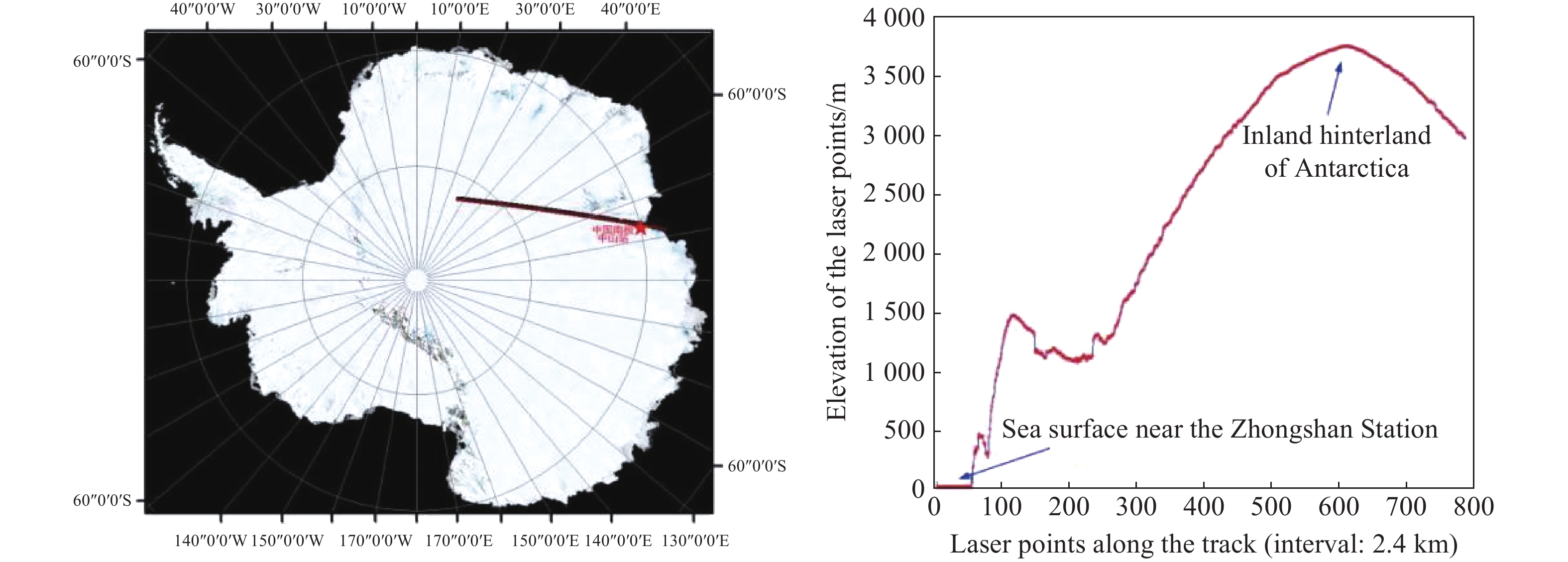
    Fig. 2. Elevation profile data of the first track obtained by the GF-7 in the polar region(captured time:21st Nov, 2019)
    Changes in the freeboard height of the Arctic Ocean sea ice from October 2018 to March 2019 obtained using ICESat-2 laser altimetry data[10]
    Fig. 3. Changes in the freeboard height of the Arctic Ocean sea ice from October 2018 to March 2019 obtained using ICESat-2 laser altimetry data[10]
    ICESat-2 trajectory in the Tibet Plateau lake (red line) and the obtained water level information of Qinghai Lake [13]
    Fig. 4. ICESat-2 trajectory in the Tibet Plateau lake (red line) and the obtained water level information of Qinghai Lake [13]
    Satellite nameLaunch timeCollecting methodBeam number Footprint diameter/m Footprint spacing/m Polar observation capability Main applications
    ICESat-12003Full wave-form170170Within 86°Polar change monitoring, terrain and forest height measurement, etc
    ICESat-22018Single photon6100.7Within 88°Polar change monitoring, terrain and forest height measurement, etc
    GEDI2018Full wave-form42560Within 51.6°Forest biomass estimation
    LIST2025Single photon1 00050.7/High precision measurement of surface elevation
    ZY3-022016Full wave-form1753 600Within 83°Laser altimetry experimental load
    GF-72019Full wave-form2< 302 400Within 83°Elevation control point acquisition
    Landcarbon monitor2021Full wave-form525-30200/Forest carbon storage monitoring, elevation control point acquisition
    Table 1.

    Main technical indicators and uses of major laser height measurement loads at home and abroad

    国内外主要激光测高载荷主要技术指标与用途

    Xiaoming Gao, Guoyuan Li, Jinquan Guo, Sida Ouyang, Wenfeng Fan. Discussion on the development of laser altimetry satellite for tri-polar regions observation[J]. Infrared and Laser Engineering, 2020, 49(11): 20200233
    Download Citation