• Acta Optica Sinica
  • Vol. 39, Issue 4, 0410001 (2019)
Fang Liu, Xin Wang*, Lixia Lu, Guangwei Huang, and Hongjuan Wang
Author Affiliations
  • Information Department, Beijing University of Technology, Beijing 100022, China
  • show less
    DOI: 10.3788/AOS201939.0410001 Cite this Article Set citation alerts
    Fang Liu, Xin Wang, Lixia Lu, Guangwei Huang, Hongjuan Wang. Landform Image Classification Based on Sparse Coding and Convolutional Neural Network[J]. Acta Optica Sinica, 2019, 39(4): 0410001 Copy Citation Text show less
    Dictionary visualization expression. (a) Example 1; (b) example 2
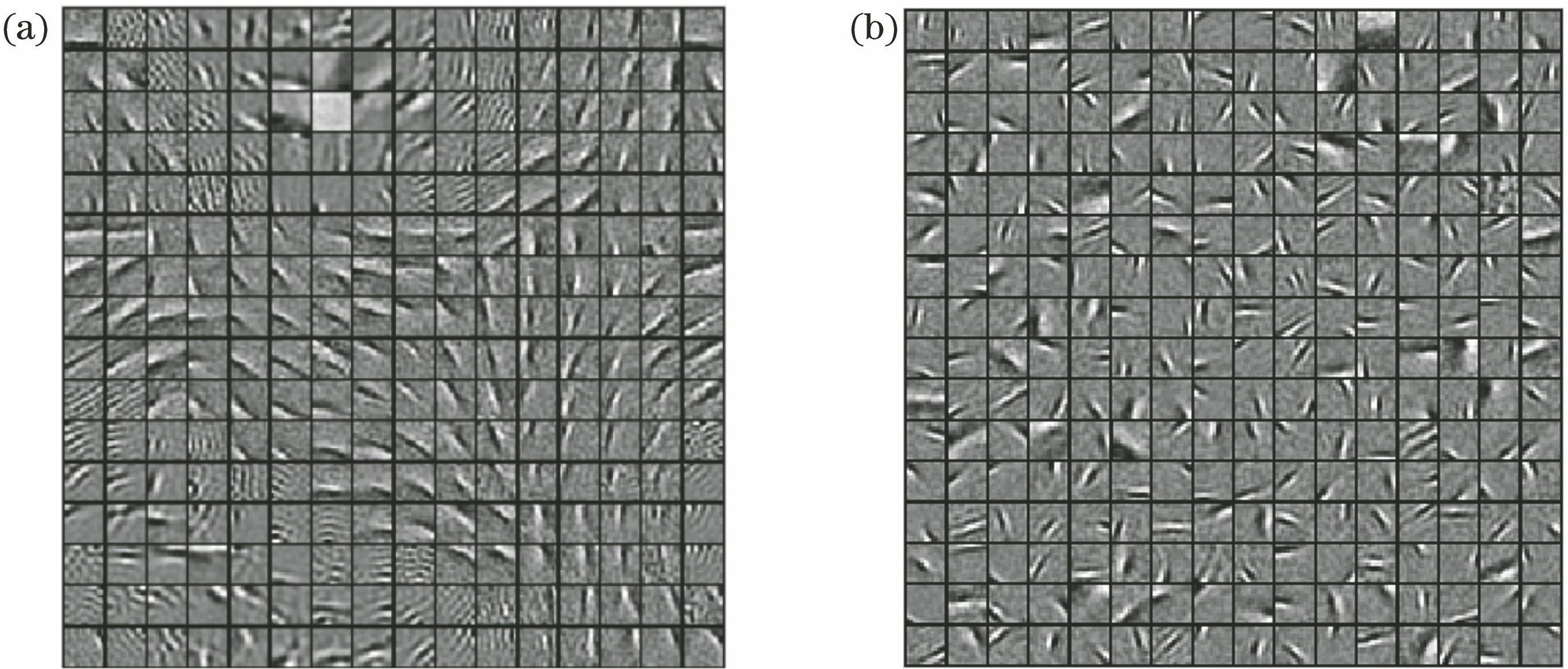
    Fig. 1. Dictionary visualization expression. (a) Example 1; (b) example 2
    Model based on SC and CNN
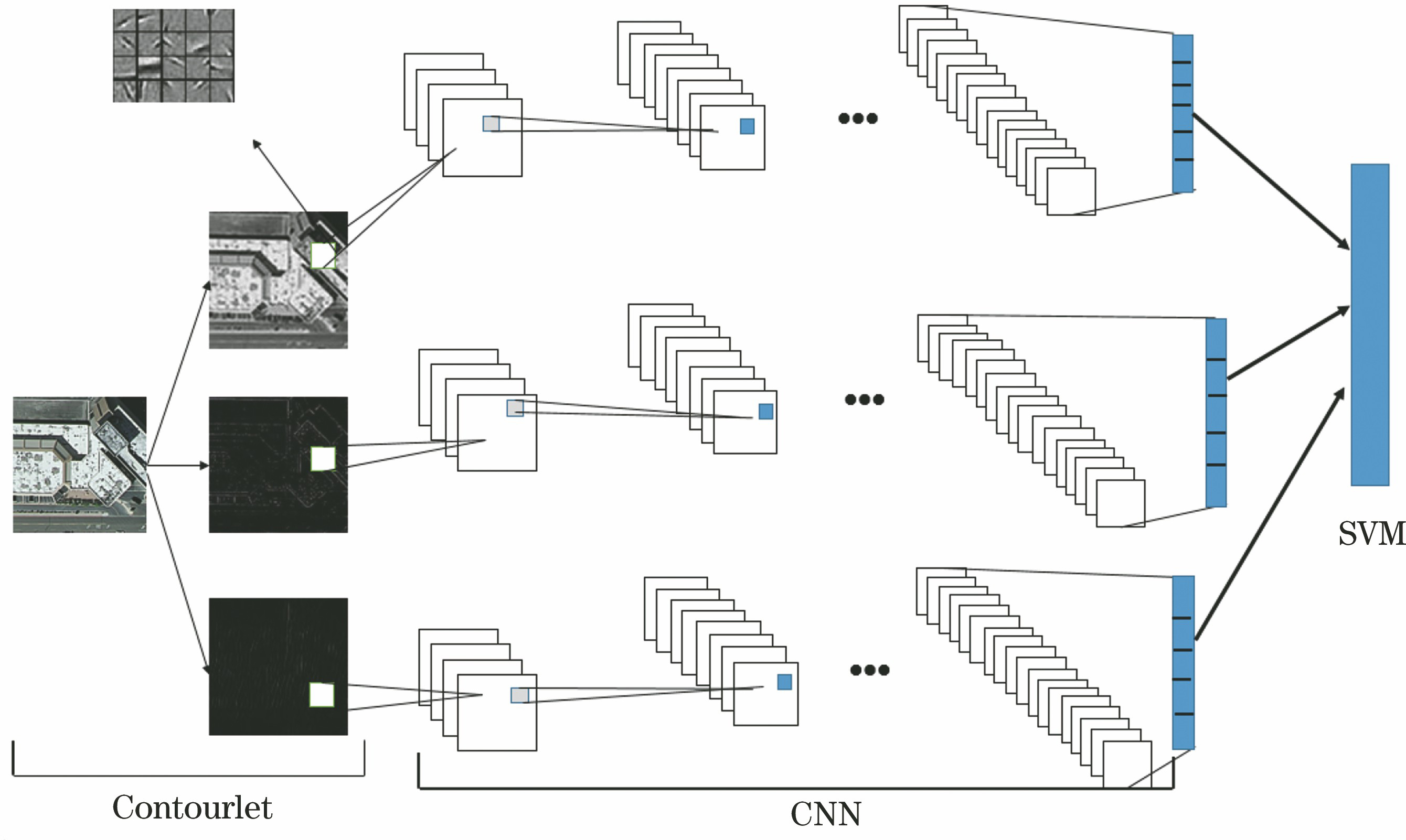
    Fig. 2. Model based on SC and CNN
    Algorithm flowchart of landform scene classification based on SC and CNN
    Fig. 3. Algorithm flowchart of landform scene classification based on SC and CNN
    Feature visualization of image blocks with size of 14×14 on two databases by using SC. (a) UAV landform database 3, before feature sorting; (b) UAV landform database 3, after feature sorting; (c) UC Merced LU database, before feature sorting (d) UC Merced LU database, after feature sorting
    Fig. 4. Feature visualization of image blocks with size of 14×14 on two databases by using SC. (a) UAV landform database 3, before feature sorting; (b) UAV landform database 3, after feature sorting; (c) UC Merced LU database, before feature sorting (d) UC Merced LU database, after feature sorting
    Training convergence curves for UC Merced LU database. (a) Training convergence curves obtained with four different methods; (b) training convergence curves obtained with SC-CNN algorithm
    Fig. 5. Training convergence curves for UC Merced LU database. (a) Training convergence curves obtained with four different methods; (b) training convergence curves obtained with SC-CNN algorithm
    Confusion matrix obtained by classify landforms with SC-CNN algorithm SC-CNN
    Fig. 6. Confusion matrix obtained by classify landforms with SC-CNN algorithm SC-CNN
    Classification effect maps of complex landforms image. (a) Landform image; (b) artificial landform division; (c) post-blocking image; (d) landform classification effect map
    Fig. 7. Classification effect maps of complex landforms image. (a) Landform image; (b) artificial landform division; (c) post-blocking image; (d) landform classification effect map
    LayerTypePatch sizeStrideZero paddingOutput size
    xInput256×256×3
    h1Convolution5×552128×128×64
    h2ReLU128×128×64
    h3Mean pooling3×3264×64×64
    h4Convolution3×32032×32×64
    h5ReLU32×32×64
    h6Max pooling3×3216×16×64
    h7Convolution7×71214×14×128
    h8ReLU14×14×128
    h9Max pooling3×327×7×128
    h10Convolution7×7101×1×128
    h11ReLU1×1×128
    h12Convolution1×1101×1×20
    oSVMv
    Table 1. Network structure of model based on SC and CNN
    AlgorithmTraining accuracy /%Training time /h
    SVM78.570.7
    CS-CNN[12]92.864.5
    PSR[13]89.105.2
    MS-DCNN[11]91.345.9
    SC-CNN98.144.3
    Table 2. Classification accuracy of different algorithms on UC Merced LU database
    AlgorithmTraining accuracy /%Training time /h
    SVM76.962.6
    CS-CNN[12]92.9112.9
    MS-DCNN[11]91.5313.7
    PCANet[14]86.4911.1
    SC-CNN97.5010.5
    Table 3. Classification accuracy of existing methods on UAV landform database 3
    Fang Liu, Xin Wang, Lixia Lu, Guangwei Huang, Hongjuan Wang. Landform Image Classification Based on Sparse Coding and Convolutional Neural Network[J]. Acta Optica Sinica, 2019, 39(4): 0410001
    Download Citation