• Journal of Geo-information Science
  • Vol. 22, Issue 4, 760 (2020)
Zhuoyuan YU1、1、2、2, Guonian LV3、3、4、4、5、5, Xining ZHANG1、1、2、2, Yuanxin JIA1、1、2、2, Chenghu ZHOU1、1、2、2, Yong GE1、1、2、2、*, and Kejing LV1、1、2、2
Author Affiliations
  • 1State Key Lab of Resources and Environmental Information System, Institute of Geographic Sciences and Natural Resources Research, Chinese Academy of Sciences, Beijing 100101, China
  • 1中国科学院地理科学与资源研究所 资源与环境信息系统国家重点实验室,北京 100101
  • 2University of Chinese Academy of Sciences, Beijing 100049, China
  • 2中国科学院大学,北京 100049
  • 3Key Laboratory of Virtual Geographic Environment, Ministry of Education, Nanjing Normal University, Nanjing 210023, China
  • 3南京师范大学 虚拟地理环境教育部重点实验室,南京 210023
  • 4Jiangsu Provincial Key Laboratory of Geographical Environment Evolution, Nanjing 210023, China
  • 4江苏省地理环境演化国家重点实验室培育建设点,南京 210023
  • 5Jiangsu Center for Collaborative Innovation in Geographical Information Resource Development and Application, Nanjing 210023, China
  • 5江苏省地理信息资源开发与利用协同创新中心,南京 210023
  • show less
    DOI: 10.12082/dqxxkx.2020.190648 Cite this Article
    Zhuoyuan YU, Guonian LV, Xining ZHANG, Yuanxin JIA, Chenghu ZHOU, Yong GE, Kejing LV. Pan-information-based High Precision Navigation Map: Concept and Theoretical Model[J]. Journal of Geo-information Science, 2020, 22(4): 760 Copy Citation Text show less
    The relationship among three kinds of maps
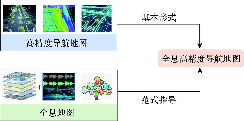
    Fig. 1. The relationship among three kinds of maps
    Structure of pan-information-based high precision navigation map
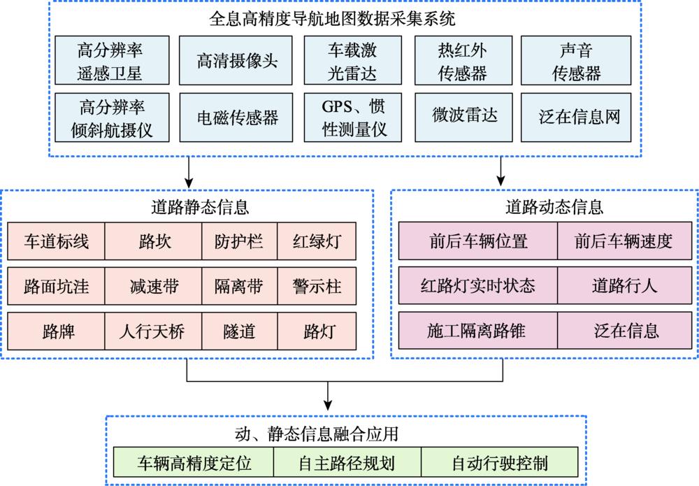
    Fig. 2. Structure of pan-information-based high precision navigation map
    Flow chart of static information collection and extrac-tion of pan-information-based high precision navigation map
    Fig. 3. Flow chart of static information collection and extrac-tion of pan-information-based high precision navigation map
    Example of road point cloud data collected by UAV
    Fig. 4. Example of road point cloud data collected by UAV
    Lane line point cloud data extraction result
    Fig. 5. Lane line point cloud data extraction result
    Point cloud cube grid structure
    Fig. 6. Point cloud cube grid structure
    Lane line point cloud grid data processing result
    Fig. 7. Lane line point cloud grid data processing result
    Lane line connection processing result
    Fig. 8. Lane line connection processing result
    Flow chart of dynamic information collection and ext-raction of pan-information-based high precision navigation map
    Fig. 9. Flow chart of dynamic information collection and ext-raction of pan-information-based high precision navigation map
    Pedestrian target recognition results
    Fig. 10. Pedestrian target recognition results
    Real-time traffic scene reconstruction based on sound data
    Fig. 11. Real-time traffic scene reconstruction based on sound data
    Schematic diagram of electromagnetic data spatialization results
    Fig. 12. Schematic diagram of electromagnetic data spatialization results
    Zhuoyuan YU, Guonian LV, Xining ZHANG, Yuanxin JIA, Chenghu ZHOU, Yong GE, Kejing LV. Pan-information-based High Precision Navigation Map: Concept and Theoretical Model[J]. Journal of Geo-information Science, 2020, 22(4): 760
    Download Citation