• Spectroscopy and Spectral Analysis
  • Vol. 41, Issue 8, 2536 (2021)
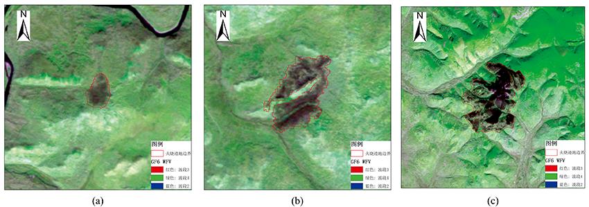
Qian LIU*, Xian-lin QIN*;, Xin-yu HU, and Zeng-yuan LI
Author Affiliations
  • Research Institute of Forest Resource Information Technique, Chinese Academy of Forestry, Key Laboratory of Forestry Remote Sensing and Information System, NFGA, Beijing 100091, China
  • show less
    DOI: 10.3964/j.issn.1000-0593(2021)08-2536-07 Cite this Article
    Qian LIU, Xian-lin QIN, Xin-yu HU, Zeng-yuan LI. Spectral and Index Analysis for Burned Areas Identification Using GF-6 WFV Data[J]. Spectroscopy and Spectral Analysis, 2021, 41(8): 2536 Copy Citation Text show less
    Study area(a): Burned area of Alongshan Forestry Bureau; (b): Burned area of Mordaga Forestry Bureau; (c): Burned area of Xiushan Forest Farm of Jinhe Forestry Bureau
    Fig. 1. Study area
    (a): Burned area of Alongshan Forestry Bureau; (b): Burned area of Mordaga Forestry Bureau; (c): Burned area of Xiushan Forest Farm of Jinhe Forestry Bureau
    Spectral curves of typical categories extracted by GF-6 WFV
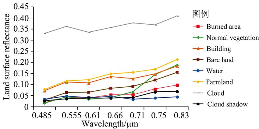
    Fig. 2. Spectral curves of typical categories extracted by GF-6 WFV
    Means and standard deviations of land surface reflectance of burned areas and unburned vegetation in different bands
    Fig. 3. Means and standard deviations of land surface reflectance of burned areas and unburned vegetation in different bands
    Separability value of different indices between burned areas and the seven categories
    Fig. 4. Separability value of different indices between burned areas and the seven categories
    编号研究区火灾发生日期火场中心经纬度过火面积/hm2
    1阿龙山林业局火烧迹地2019年6月19日121°17'24″E , 51°53'24″N39
    2莫尔道嘎林业局火烧迹地2019年6月19日121°16'57″E , 51°47'51″N182
    3金河林业局秀山林场火烧迹地2019年6月19日122°20'38″E , 51°31'10″N1 883
    Table 1. Forest fire information of the study area
    波段波段范围/μm
    蓝波段(B1)0.45~0.52
    绿波段(B2)0.52~0.59
    红波段(B3)0.63~0.69
    近红外波段(B4)0.77~0.89
    红边1波段(B5)0.69~0.73
    红边2波段(B6)0.73~0.77
    紫波段(B7)0.40~0.45
    黄波段(B8)0.59~0.63
    Table 2. General parameters of GF-6 WFV data
    名称缩写公式使用的GF-6 WFV波段
    归一化植被指数NDVINDVI=ρNIR-ρREDρNIR+ρREDB3, B4
    全球环境监测指数GEMIGEMI=η(1-0.25η)-ρRED-0.1251-ρRED
    η=2(ρNIR2-ρRED2)+1.5ρNIR+0.5ρREDρRED+ρNIR+0.5
    B3, B4
    增强植被指数EVIEVI=2.5(ρNIR-ρRED)ρNIR+6ρRED-7.5ρBLUE+1B1, B3, B4
    燃烧面积指数BAIBAI=1(ρNIR-0.06)2+(ρRED-0.1)2B3, B4
    土壤调节植被指数SAVISAVI=(1+L)(ρNIR-ρRED)ρNIR+ρRED+L, L=0.5B3, B4
    改进型土壤调节植被指数MSAVIMSAVI=2ρNIR+1-(2ρNIR+1)2-8(ρNIR-ρRED)2B3, B4
    归一化差异水体指数NDWINDWI=ρGREEN-ρNIRρGREEN+ρNIRB2, B4
    地面叶绿素指数MTCIMTCI=ρRE2-ρRE1ρRE1-ρREDB3, B5, B6
    归一化差值红边指数NDRE1NDRE1=ρRE2-ρRE1ρRE2+ρRE1B5, B6
    改进的叶绿素吸收指数MCARI2MCARI2=[(ρRE2-ρRE1)-0.2(ρRE2-ρGREEN)]ρRE2ρRE1B2, B5, B6
    改进的归一化土壤指数MNDSIMNDSI=ρGREEN-ρYELLOWρGREEN+ρYELLOWB2, B8
    Table 3. The formulas of indices
    波段区分度
    B10.25
    B20.51
    B30.16
    B41.68
    B51.09
    B61.80
    B80.18
    Table 4. Separability value of GF-6 WFV different bands between burned areas and vegetation in pro-fire
    光谱指数区分度改进指数区分度
    NDVI3.11MTCI0.06
    GEMI2.08NDRE11.33
    EVI2.71MCARI22.19
    BAI2.05MNDSI0.83
    SAVI2.62
    MSAVI2.53
    NDWI2.57
    Table 5. Separability value of GF-6 WFV different indices between burned areas and vegetation in pro-fire
    指数Kappa系数指数差值Kappa系数
    NDVI0.70dNDVI0.89
    GEMI0.82dGEMI0.92
    EVI0.85dEVI0.93
    BAI0.82dBAI0.87
    SAVI0.85dSAVI0.93
    MSAVI0.85dMSAVI0.93
    NDWI0.57dNDWI0.80
    MTCI0.52dMTCI0.52
    NDRE10.23dNDRE10.61
    MCARI20.74dMCARI20.82
    MNDSI0.51dMNDSI0.61
    Table 6. Accuracy of burned area identification of Xiushan Forest Farm of Jinhe Forestry Bureau using different indices
    Qian LIU, Xian-lin QIN, Xin-yu HU, Zeng-yuan LI. Spectral and Index Analysis for Burned Areas Identification Using GF-6 WFV Data[J]. Spectroscopy and Spectral Analysis, 2021, 41(8): 2536
    Download Citation