• Journal of Geographical Sciences
  • Vol. 30, Issue 6, 1005 (2020)
Erfu DAI1、2 and Yahui WANG、*
Author Affiliations
  • 1. Lhasa Plateau Ecosystem Research Station, Key Laboratory of Ecosystem Network Observation and Modeling, Institute of Geographic Sciences and Natural Resources Research, CAS, Beijing 100101, China
  • 2. University of Chinese Academy of Sciences, Beijing 100049, China
  • show less
    DOI: 10.1007/s11442-020-1767-y Cite this Article
    Erfu DAI, Yahui WANG. Attribution analysis for water yield service based on the geographical detector method: A case study of the Hengduan Mountain region[J]. Journal of Geographical Sciences, 2020, 30(6): 1005 Copy Citation Text show less
    Location, land use type, geomorphology, and climate division of the Hengduan Mountain region
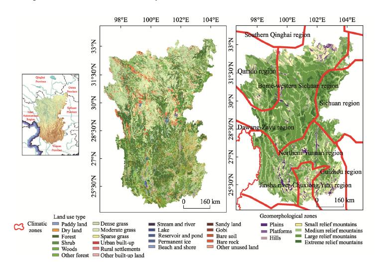
    Fig. 1. Location, land use type, geomorphology, and climate division of the Hengduan Mountain region
    Framework for the spatial heterogeneity and driving mechanism of water yield service
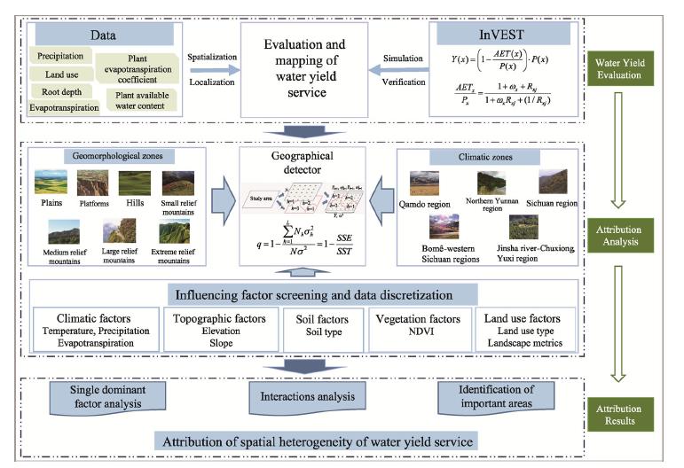
    Fig. 2. Framework for the spatial heterogeneity and driving mechanism of water yield service
    Spatial pattern of water yield service in the Hengduan Mountain region
    Fig. 3. Spatial pattern of water yield service in the Hengduan Mountain region
    Influence of different driving factors on spatial heterogeneity of water yield in different climatic and geomorphological zones
    Fig. 4. Influence of different driving factors on spatial heterogeneity of water yield in different climatic and geomorphological zones
    CategoryIndicatorsData typeCategoryIndicatorsData type
    ClimateAnnual average temperatureContinuousLand useLand use typesDiscrete
    PrecipitationContinuousSHDIContinuous
    Solar radiationContinuousCONTAGContinuous
    Actual evapotranspirationContinuousMESHContinuous
    TopographyElevationContinuousPLAND (cultivated land)Continuous
    SlopeContinuousPLAND (forests)Continuous
    SoilSoil typeDiscretePLAND (grassland)Continuous
    VegetationNDVIContinuous
    Table 1.

    Driving factors for water yield spatial heterogeneity in the Hengduan Mountain region

    RegionsDominant interactions
    Entire mountain regionPrecipitation∩actual evapotranspiration, precipitation∩land use type, precipitation∩soil type
    PlainsPrecipitation∩actual evapotranspiration, precipitation∩land use type, actual evapotranspiration∩soil type/elevation
    PlatformsPrecipitation∩actual evapotranspiration, precipitation∩land use type, actual evapotranspiration∩MESH metric
    HillsPrecipitation∩actual evapotranspiration, actual evapotranspiration∩elevation, precipitation∩land use type
    Small relief mountainsPrecipitation∩actual evapotranspiration, precipitation∩land use type, precipitation∩soil type
    Medium relief mountainsPrecipitation∩actual evapotranspiration, precipitation∩land use type, precipitation∩soil type
    Large relief mountainsPrecipitation∩actual evapotranspiration, precipitation∩land use type, precipitation∩soil type
    Extreme relief mountainsPrecipitation∩actual evapotranspiration, precipitation∩land use type, precipitation∩PLAND(grassland)
    Qamdo regionPrecipitation∩actual evapotranspiration, actual evapotranspiration∩other factors
    Bomê-western Sichuan regionPrecipitation∩actual evapotranspiration, precipitation∩land use type, actual evapotranspiration∩other factors
    Sichuan regionPrecipitation∩actual evapotranspiration, actual evapotranspiration∩land use type
    Jinsha river-Chuxiong, Yuxi regionPrecipitation∩actual evapotranspiration, actual evapotranspiration∩land use type
    Northern Yunnan regionPrecipitation∩actual evapotranspiration, precipitation∩land use type, precipitation∩soil type
    Table 2.

    The dominant interactions between two driving factors in different climatic and geomorphological zones in the Hengduan Mountain region

    RegionsElevation (m)Slope (°)Soil typeNDVILand use type
    Entire mountain region1591-248425-35Primarosol0.78-0.94Shrub
    Plains2069-24840.72-0.78Shrub
    Platforms2069-2484Primarosol0.78-0.94Shrub
    Hills3377-3797Primarosol0.78-0.94Woods, shrub
    Small relief mountains2069-248425-35Primarosol0.78-0.94Shrub
    Medium relief mountains2069-248425-35Primarosol0.78-0.94Shrub
    Large relief mountains2069-2484Primarosol0.78-0.94Shrub
    Extreme relief mountains2924-337725-350.78-0.94Shrub
    Qamdo region3797-68080-5Primarosol0.78-0.94Shrub
    Bomê-western Sichuan region347-15910-5Primarosol, anthropogenic soil0.78-0.94Shrub
    Sichuan region347-15910-5Primarosol, anthropogenic soilShrub, other forests
    Jinsha river-Chuxiong, Yuxi region1591-20690-5Primarosol0.72-0.78Shrub
    Northern Yunnan region3797-454825-35Primarosol0.78-0.94Sparse grass
    Table 3.

    Water yield identification for important areas in different climatic and geomorphological zones in the Hengduan Mountain region

    Erfu DAI, Yahui WANG. Attribution analysis for water yield service based on the geographical detector method: A case study of the Hengduan Mountain region[J]. Journal of Geographical Sciences, 2020, 30(6): 1005
    Download Citation