• Acta Optica Sinica
  • Vol. 37, Issue 8, 0828003 (2017)
Yufeng Cheng1, Shuying Jin1、*, Mi Wang1, Xueli Chang2, and Ying Zhu1
Author Affiliations
  • 1 State Key Laboratory of Information Engineering in Surveying, Mapping and Remote Sensing, Wuhan University, Wuhan, Hubei 430079, China
  • 2 School of Resource and Environment Sciences, Wuhan University, Wuhan, Hubei 430079, China
  • show less
    DOI: 10.3788/AOS201737.0828003 Cite this Article Set citation alerts
    Yufeng Cheng, Shuying Jin, Mi Wang, Xueli Chang, Ying Zhu. An High Accuracy Image Mosaicking Approach of Optical Remote Sensing Satellite for Multi-Camera System[J]. Acta Optica Sinica, 2017, 37(8): 0828003 Copy Citation Text show less
    Sketch map of imaging and mosaicking of multi-camera system on GF-2
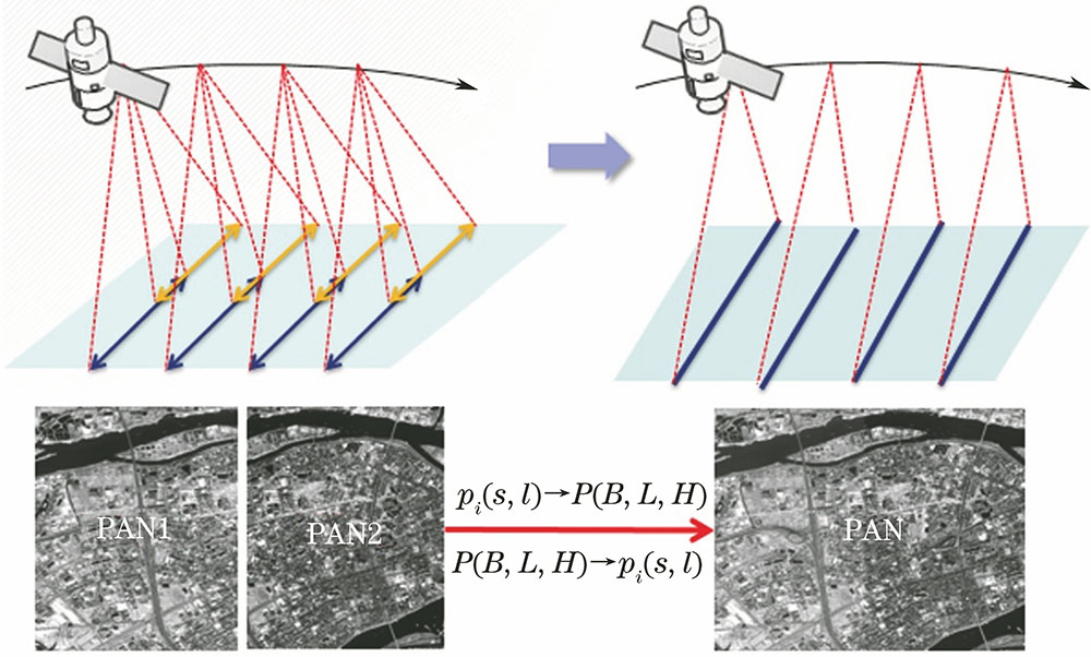
    Fig. 1. Sketch map of imaging and mosaicking of multi-camera system on GF-2
    Sketch map of multi-camera on GF-1
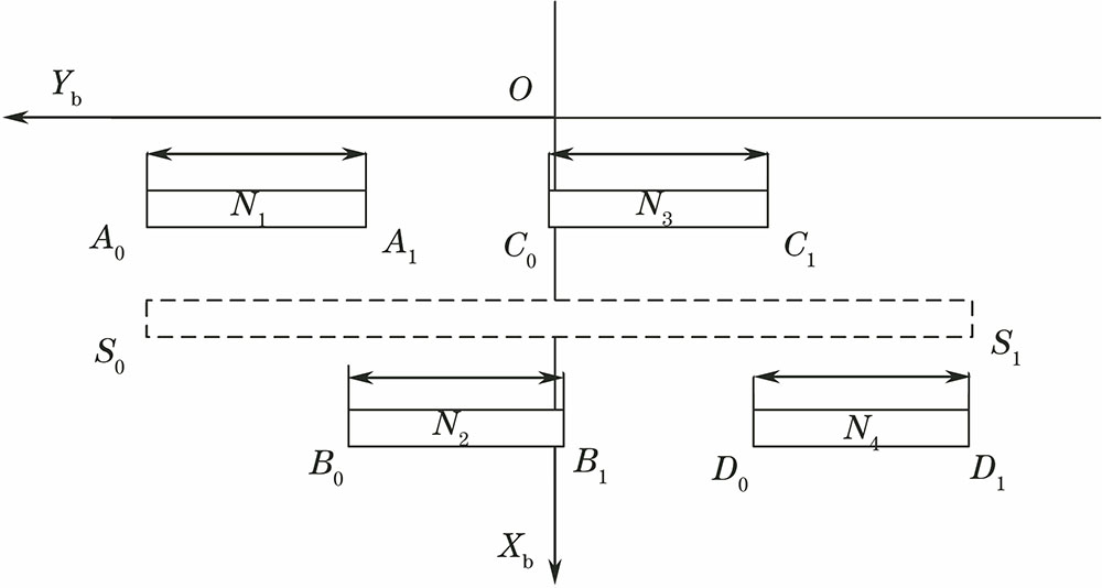
    Fig. 2. Sketch map of multi-camera on GF-1
    Sketch map of homonymy points in the overlapping region of multi-camera system
    Fig. 3. Sketch map of homonymy points in the overlapping region of multi-camera system
    Influence of elevation error
    Fig. 4. Influence of elevation error
    Stitched images of GF-1. (a) Global graph of the stitched image; (b) box 1 region; (c) box 2 region; (d) box 3 region
    Fig. 5. Stitched images of GF-1. (a) Global graph of the stitched image; (b) box 1 region; (c) box 2 region; (d) box 3 region
    Stitched images of GF-2. (a) Global graph of the stitched image; (b) box 1 region; (c) box 2 region; (d) box 3 region
    Fig. 6. Stitched images of GF-2. (a) Global graph of the stitched image; (b) box 1 region; (c) box 2 region; (d) box 3 region
    AreaImaging timeSensorSingle image size /(pixel×pixel)TerrainReference data
    GF-1Yangtze riverbasin2016-05-16WFV12000×13400Flatland, mountain elevationAverage: 50 mDifference: 3000 mDOM: 15 mLandsat8 panchromatic imageDEM: 30 m GDEM2
    GF-2Yili2016-06-22HR29200×27620Flatland, mountain elevationAverage: 700 mDifference: 900 mDOM: 0.3 m aerial imageDEM: 2 m aerial image
    Table 1. Specification of experimental data
    SatelliteLine /pixelSample /pixel
    Maximum errorRMSEMaximum errorRMSE
    GF-10.00002370.00001320.00002580.0000143
    GF-20.00036530.00020490.00034270.0002276
    Table 2. Fitting accuracy evaluation for RFM of stitched images
    CameraAbsolute accuracy (without ground control points) /pixelInternal accuracy (with ground control points) /pixel
    SampleLineSampleLine
    Camera 12.275-5.4520.6740.616
    Camera 22.782-5.5610.7790.722
    Camera 32.153-5.2430.7220.742
    Camera 41.584-5.2890.8060.742
    Big virtual camera1.985-5.3890.8590.834
    Table 3. Geometric accuracy evaluation of GF-1 stitched images
    CameraAbsolute accuracy (without ground control points) /pixelInternal accuracy (with ground control points) /pixel
    SampleLineSampleLine
    Camera 132.31022.4631.8941.965
    Camera 232.45926.6751.8831.971
    Big virtual camera32.45024.0012.0122.183
    Table 4. Geometric accuracy evaluation of GF-2 stitched images
    Yufeng Cheng, Shuying Jin, Mi Wang, Xueli Chang, Ying Zhu. An High Accuracy Image Mosaicking Approach of Optical Remote Sensing Satellite for Multi-Camera System[J]. Acta Optica Sinica, 2017, 37(8): 0828003
    Download Citation