• Acta Optica Sinica
  • Vol. 41, Issue 3, 0328001 (2021)
Ao Li1, Xinming Tang1、2、*, and Xiaoyong Zhu2、**
Author Affiliations
  • 1College of Geodesy and Geomatics, Shandong University of Science and Technology, Qingdao, Shandong 266510, China
  • 2Land Satellites Remote Sensing Application Center, Ministry of Natural Resources, Beijing 100048, China
  • show less
    DOI: 10.3788/AOS202141.0328001 Cite this Article Set citation alerts
    Ao Li, Xinming Tang, Xiaoyong Zhu. Geometric Positioning Accuracy Evaluation of Domestic High-Resolution Satellite Images Based on Unified Verification Field Method[J]. Acta Optica Sinica, 2021, 41(3): 0328001 Copy Citation Text show less
    Multiple domestic high-resolution satellite images and control point distribution map
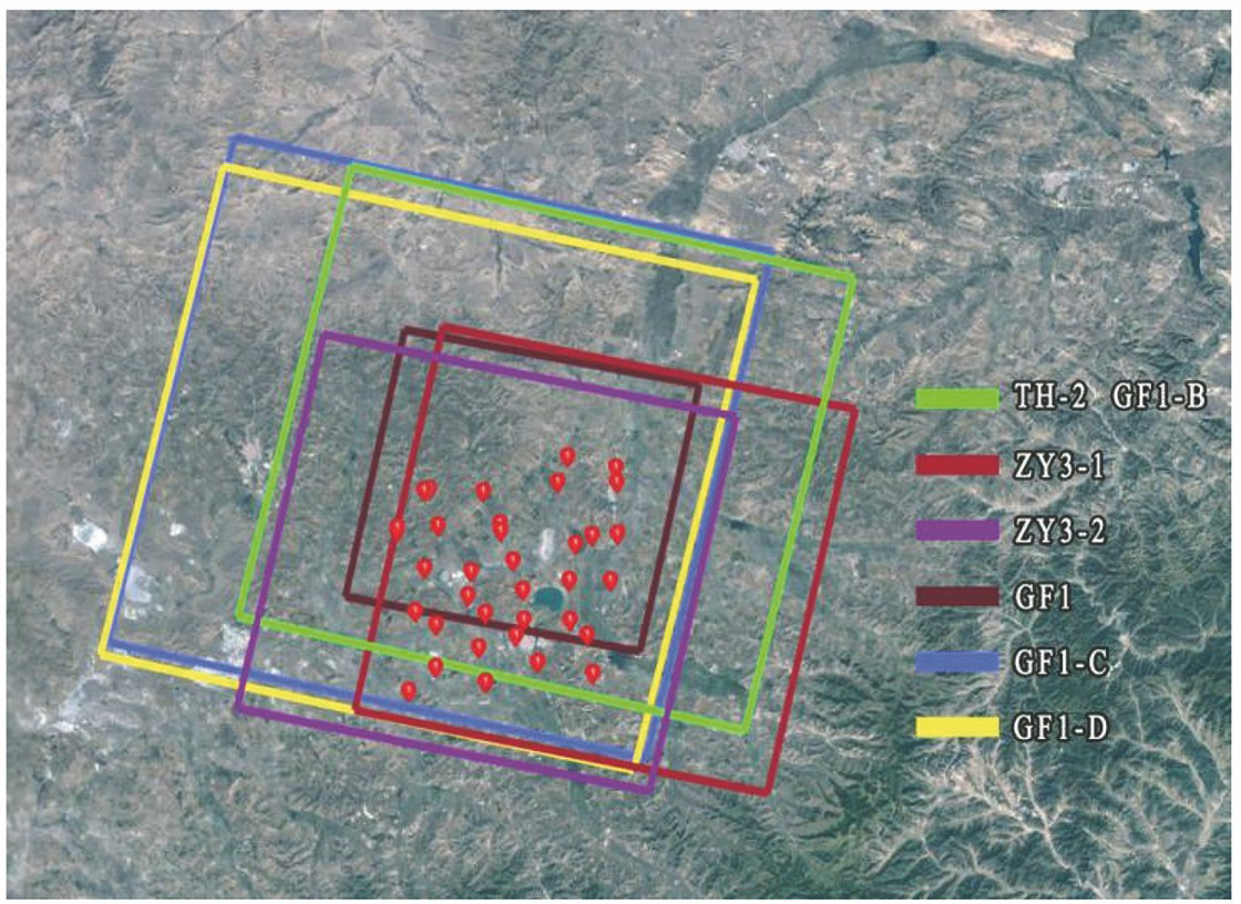
    Fig. 1. Multiple domestic high-resolution satellite images and control point distribution map
    Distribution of plane error of stereo image in Guyuan region. (a) Without control points; (b) four control points; (c) all control points
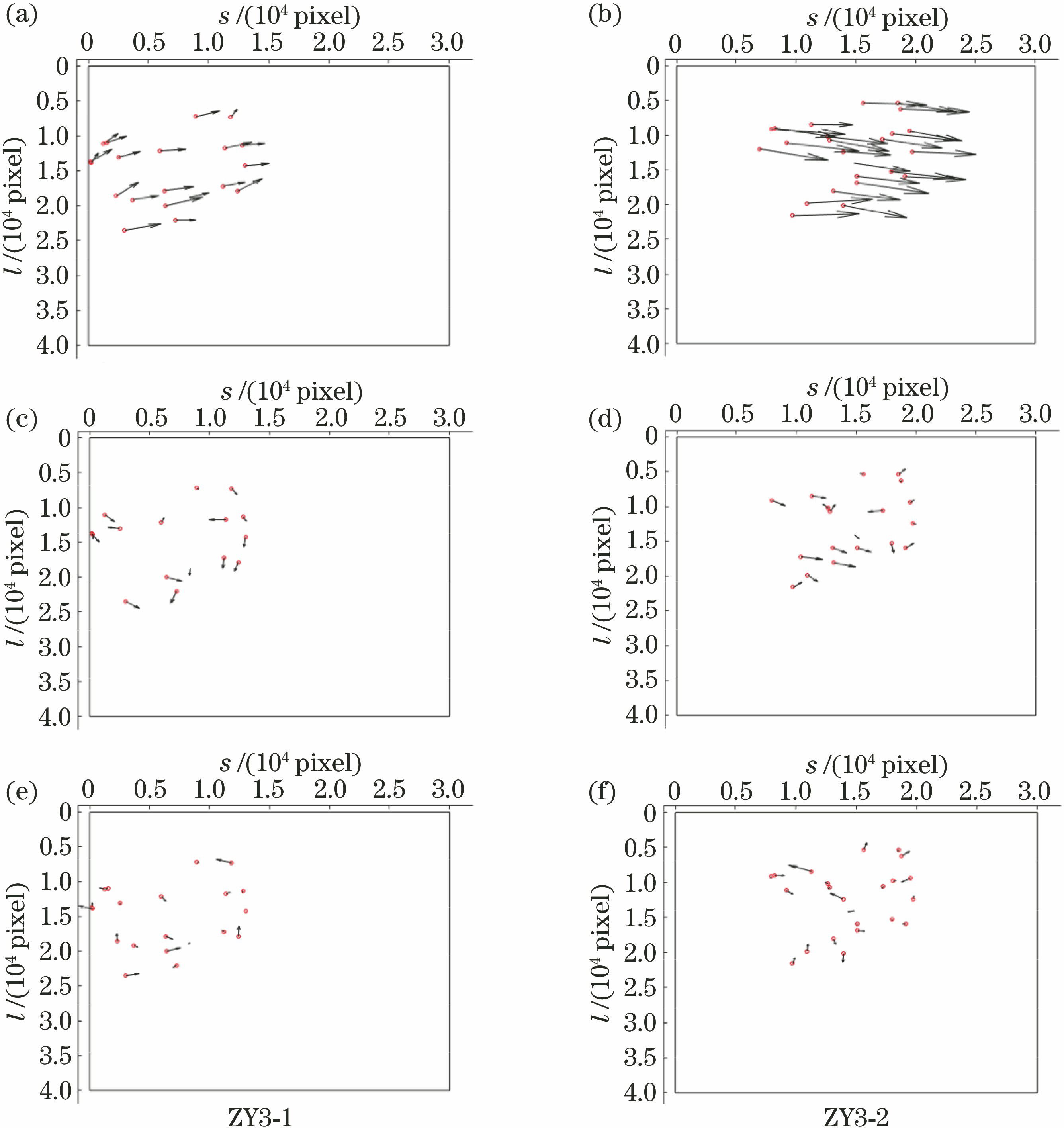
    Fig. 2. Distribution of plane error of stereo image in Guyuan region. (a) Without control points; (b) four control points; (c) all control points
    Elevation error distribution of stereo image in Guyuan region. (a) ZY3-1; (b) ZY3-2
    Fig. 3. Elevation error distribution of stereo image in Guyuan region. (a) ZY3-1; (b) ZY3-2
    SatelliteLaunchingyearOrbitheight /kmSpatialresolution /mWidth ofimage /kmImagingtimeNumber ofGCP
    ZY3-120125052.1(PAN)5.8(MS)502019-09-2732
    ZY3-220165052.1(PAN)5.8(MS)502017-09-2232
    GF120136452(PAN)8(MS)602018-12-0722
    GF1-B20186452(PAN)8(MS)602018-11-0129
    GF1-C20186452(PAN)8(MS)602019-10-1230
    GF1-D20186452(PAN)8(MS)602018-10-0226
    TH-120125052(PAN)8(MS)602018-09-1628
    Table 1. Basic parameters and test image information of domestic satellites (PAN: panchromatic image; MS: multispectral image)
    SatelliteNumber of GCPNumber of CIPRMSE of ICP /pixel
    xyPlane
    GF103212.8712.8917.08
    5272.422.043.16
    GF1-B03216.1113.2320.85
    5274.062.985.03
    GF1-C0228.4515.6517.79
    5173.092.493.97
    GF1-D02919.4887.6989.83
    5245.184.176.65
    ZY3-10304.631.885.00
    5251.291.091.69
    ZY3-203611.355.912.80
    5311.612.042.60
    TH-10282.491.993.18
    5231.611.792.41
    Table 2. Geometric positioning accuracy of single scene satellite image
    SatelliteNumberof GCPNumberof CIPRMSE of ICP /mRMSE of GCP /m
    xyPlaneHeightxyPlaneHeight
    0249.975.311.293.43----
    ZY3-14200.760.530.930.593.4756.091.79
    240----2.962.694.011.71
    02725.585.3226.125.28----
    ZY3-24231.741.762.472.584.763.415.861.63
    270----2.993.084.291.61
    Table 3. Accuracy statistics of domestic satellite stereo image adjustment in test area under different control points
    Ao Li, Xinming Tang, Xiaoyong Zhu. Geometric Positioning Accuracy Evaluation of Domestic High-Resolution Satellite Images Based on Unified Verification Field Method[J]. Acta Optica Sinica, 2021, 41(3): 0328001
    Download Citation