• Journal of Infrared and Millimeter Waves
  • Vol. 39, Issue 5, 626 (2020)
Quan CHEN1、2、3, Zhong-Fa ZHOU1、2、3、*, Ling-Yu WANG1、2、3, Yu-Sheng DAN1、2、3, and Yun-Tao TANG1、2、3
Author Affiliations
  • 1School of Geography and Environmental Science/School of Karst Science, Guizhou Normal University, Guiyang550001,China
  • 2The State Key Laboratory Incubation Base for Karst Mountain Ecology Environment of Guizhou Province, Guiyang550001,China
  • 3State Engineering Technology Institute for Karst Desertification Control, Guiyang550001,China
  • show less
    DOI: 10.11972/j.issn.1001-9014.2020.05.014 Cite this Article
    Quan CHEN, Zhong-Fa ZHOU, Ling-Yu WANG, Yu-Sheng DAN, Yun-Tao TANG. Surface soil moisture retrieval using multi-temporal Sentinel-1 SAR data in karst rocky desertification area[J]. Journal of Infrared and Millimeter Waves, 2020, 39(5): 626 Copy Citation Text show less
    Study area and sampling spots. Note: The left-hand section provides a sketch map of Guizhou province. The right-hand section provides an overview of the SAR data(R: 2018/06/09VV polarization,G:2018/06/21 VV polarization,B:2018/07/03 VV polarization)and geomorphic type (Ⅰ: Peak cluster depression, Ⅱ: Mound-peak platform, Ⅲ: Erosion platform, Ⅳ: Erosion steep slope, Ⅴ: Box canyon)and sample spots of the field survey
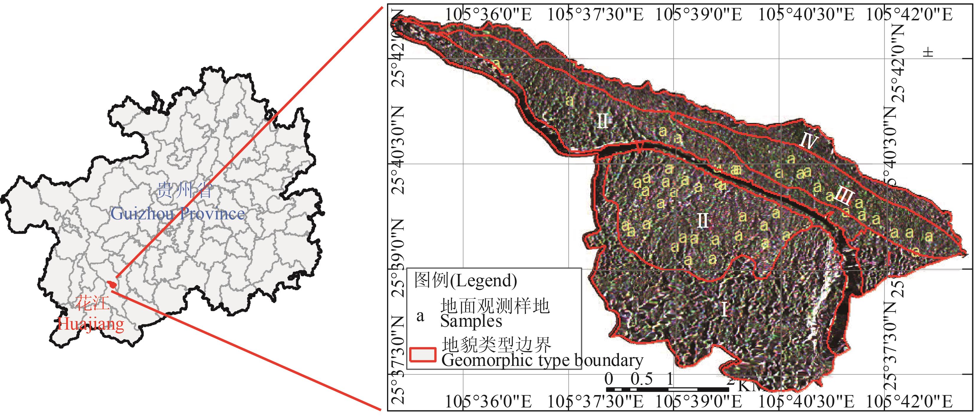
    Fig. 1. Study area and sampling spots. Note: The left-hand section provides a sketch map of Guizhou province. The right-hand section provides an overview of the SAR data(R: 2018/06/09VV polarization,G:2018/06/21 VV polarization,B:2018/07/03 VV polarization)and geomorphic type (Ⅰ: Peak cluster depression, Ⅱ: Mound-peak platform, Ⅲ: Erosion platform, Ⅳ: Erosion steep slope, Ⅴ: Box canyon)and sample spots of the field survey
    Statistics maps of soil moisture for different acquisition dates
    Fig. 2. Statistics maps of soil moisture for different acquisition dates
    Soil moisture maps for different acquisition dates
    Fig. 3. Soil moisture maps for different acquisition dates
    Comparison between of measured and estimated soil moisture at time T4
    Fig. 4. Comparison between of measured and estimated soil moisture at time T4
    Data distribution maps of soil moisture measured, estimated values and error values in 47 measured plots
    Fig. 5. Data distribution maps of soil moisture measured, estimated values and error values in 47 measured plots

    序号

    ID

    成像时间

    Acquisition

    date

    平均入射角

    Mean incidence

    angle/ (°)

    成像模式

    Imaging model

    数据类型

    Data type

    极化方式

    Polarization

    T12018/06/09/22:5738.6IWLevel1 GRDVH/VV
    T22018/06/21/22:5738.6IWLevel1 GRDVH/VV
    T32018/07/03/22:5738.6IWLevel1 GRDVH/VV
    T42018/07/15/22:5738.6IWLevel1 GRDVH/VV
    Table 1. 研究区SAR数据信息表

    日期

    Date

    含水量最小值

    Min soil moisture /

    (cm3.cm-3

    含水量最大值

    Max soil moisture/

    (cm3.cm-3

    含水量均值

    Mean soil moisture / (cm3.cm-3

    方差

    Var

    标准差

    Stdev

    T10.0240.3090.1430.0040.065
    T20.0510.6380.2370.0140.116
    T30.0350.3610.1520.0060.076
    T40.0390.4510.1890.0080.091
    Table 2. 土壤体积含水量反演结果统计
    Quan CHEN, Zhong-Fa ZHOU, Ling-Yu WANG, Yu-Sheng DAN, Yun-Tao TANG. Surface soil moisture retrieval using multi-temporal Sentinel-1 SAR data in karst rocky desertification area[J]. Journal of Infrared and Millimeter Waves, 2020, 39(5): 626
    Download Citation