
Ruifei Zhu, Jingyu Ma, Zhuqiang Li, Dong Wang, Yuan An, Xing Zhong, Fang Gao, Xiangyu Meng. Domestic Multispectral Image Classification Based on Multilayer Perception Convolutional Neural Network[J]. Acta Optica Sinica, 2020, 40(15): 1528003
- Acta Optica Sinica
- Vol. 40, Issue 15, 1528003 (2020)
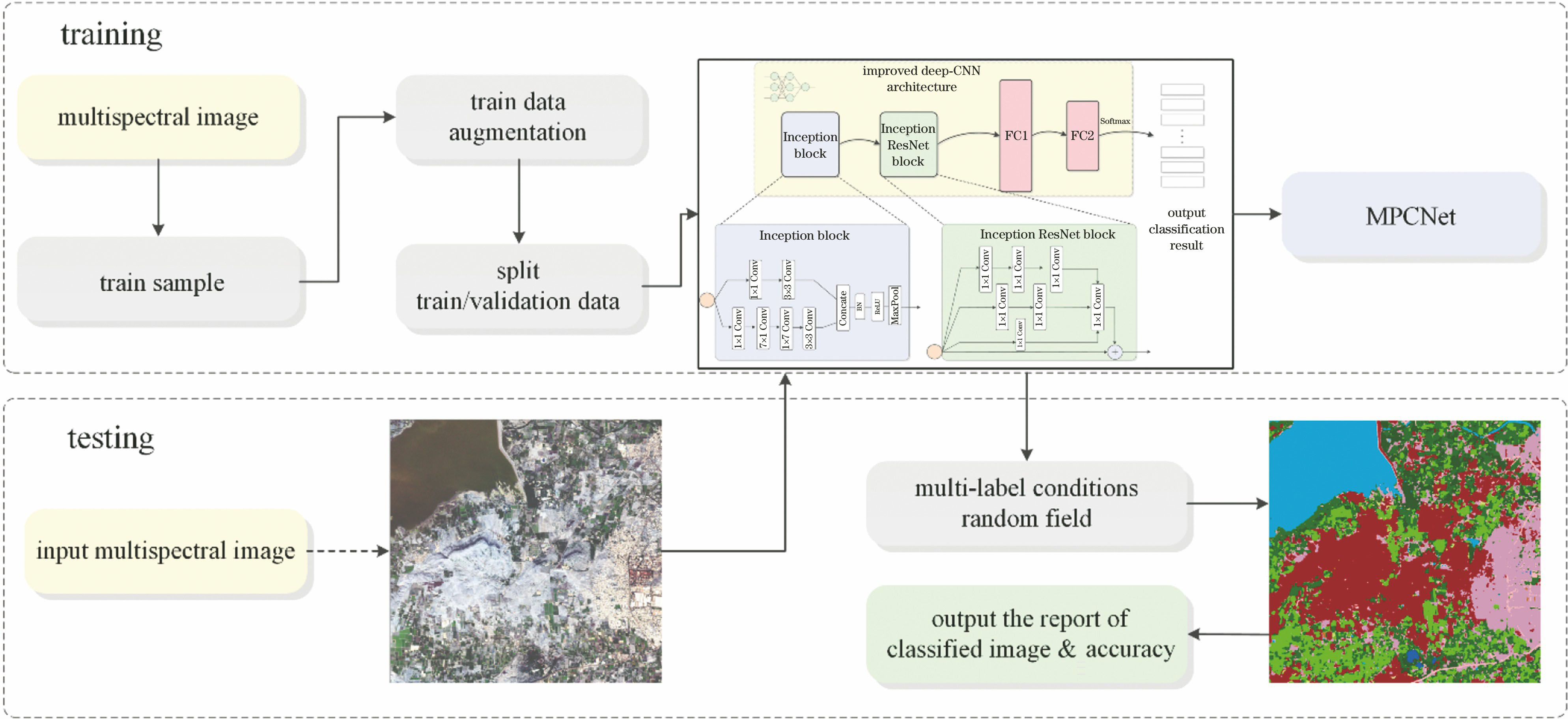
Fig. 1. Flow chart of MPCNet classification algorithm

Fig. 2. Multispectral remote sensing image classification model based on MPCNet
Fig. 3. Introduction of experimental data. (a) True color image of Jilin-1GP01; (b) true color image of Landsat8; (c) true color image of Sentinel-2A; (d) true color image of HJ-1A; (e) high resolution image of Google Earth; (f) land cover product of FROM-GLC-2017
Fig. 4. Reflectivity curves of samples in Nashik research area of Jilin-1GP01. (a) Uncultivated land; (b) cultivated land; (c) building; (d) grassland; (e) bare land; (f) road; (g) forest land; (h) water; (i) cloud; (j) shadow
Fig. 5. Classification results using MPCNet algorithm. (a) Jilin-1GP01 image; (b) Landsat8 image; (c) Sentinel-2A image; (d) HJ-1A image
Fig. 6. Classification detail results of surface features at local Nashik area. (a) Pseudo-color composite image; (b) local enlargement image; (c) classification result by Jilin-1GP01; (d) classification result by Sentinel-2A; (e) remote sensing image superimposed vector data
Fig. 7. Classification results of different algorithms on Jilin-1GP01 images in Nashik. (a) Local image; (b) SVM; (c) LGBM-GBDT; (d) shallow CNN; (e) MPCNet
Fig. 8. Classification results of different algorithms on Jilin-1GP02 images in Xintai city. (a) Local image; (b) SVM; (c) LGBM-GBDT; (d) shallow CNN; (e) MPCNet
|
Table 1. Band selection, spatial resolution, and shooting time of multispectral satellite
|
Table 2. Band selection, spatial resolution, and shooting time of Jilin-1GP02
| |||||||||||||||||||||||||||||||||||||||||||||||||||||||||||||||||||||||||||||||||||||||||||||||||||||||||||||||||||||||||||||||||||||||||||||||||||||||||||||||||||||||||||||||||||||||||
Table 3. Classification accuracy evaluation index of different satellite data based on MPCNet algorithm
| |||||||||||||||||||||||||||||||||||||||||||||||||||||||||||||||||||||||||||||||||||||||||||||||||||||||||||||||||||||||||||||||||||||||||||||||||||||||||||||||||||||||||||||||||||||||||
Table 4. Classification accuracy evaluation index of different algorithms on Jilin-1GP01 images
| |||||||||||||||||||||||||||||||||||||||||||||||||||||||||||||||||||||||||||||||||||||||||||||||||||||||||||||||||||||||||||||||||||||||||||||||||||||||||||||||||||||||||
Table 5. Classification accuracy evaluation index of different algorithms on Jilin-1GP02 images
|
Table 6. Processing efficiency of different algorithms on Jilin-1GP01 images

Set citation alerts for the article
Please enter your email address
© Copyright 2018-2021 | Chinese Laser Press. All Rights Reserved 沪ICP备15018463号-20