• Journal of Geographical Sciences
  • Vol. 30, Issue 9, 1419 (2020)
Xiaojing LIU1, Dianfeng LIU1、2、*, Hongzhuo ZHAO1, Jianhua HE1、2, and Yaolin LIU1、2、3
Author Affiliations
  • 1School of Resource and Environmental Science, Wuhan University, Wuhan 430079, China
  • 2Key Laboratory of Digital Cartography and Land Information Engineering, Ministry of Natural Resources, Wuhan University, Wuhan 430079, China
  • 3Collaborative Innovation Center for Geospatial Information Science, Wuhan University, Wuhan 430079, China
  • show less
    DOI: 10.1007/s11442-020-1790-z Cite this Article
    Xiaojing LIU, Dianfeng LIU, Hongzhuo ZHAO, Jianhua HE, Yaolin LIU. Exploring the spatio-temporal impacts of farmland reforestation on ecological connectivity using circuit theory: A case study in the agro-pastoral ecotone of North China[J]. Journal of Geographical Sciences, 2020, 30(9): 1419 Copy Citation Text show less
    Analysis framework for evaluating the effect of farmland reforestation on ecological connectivity
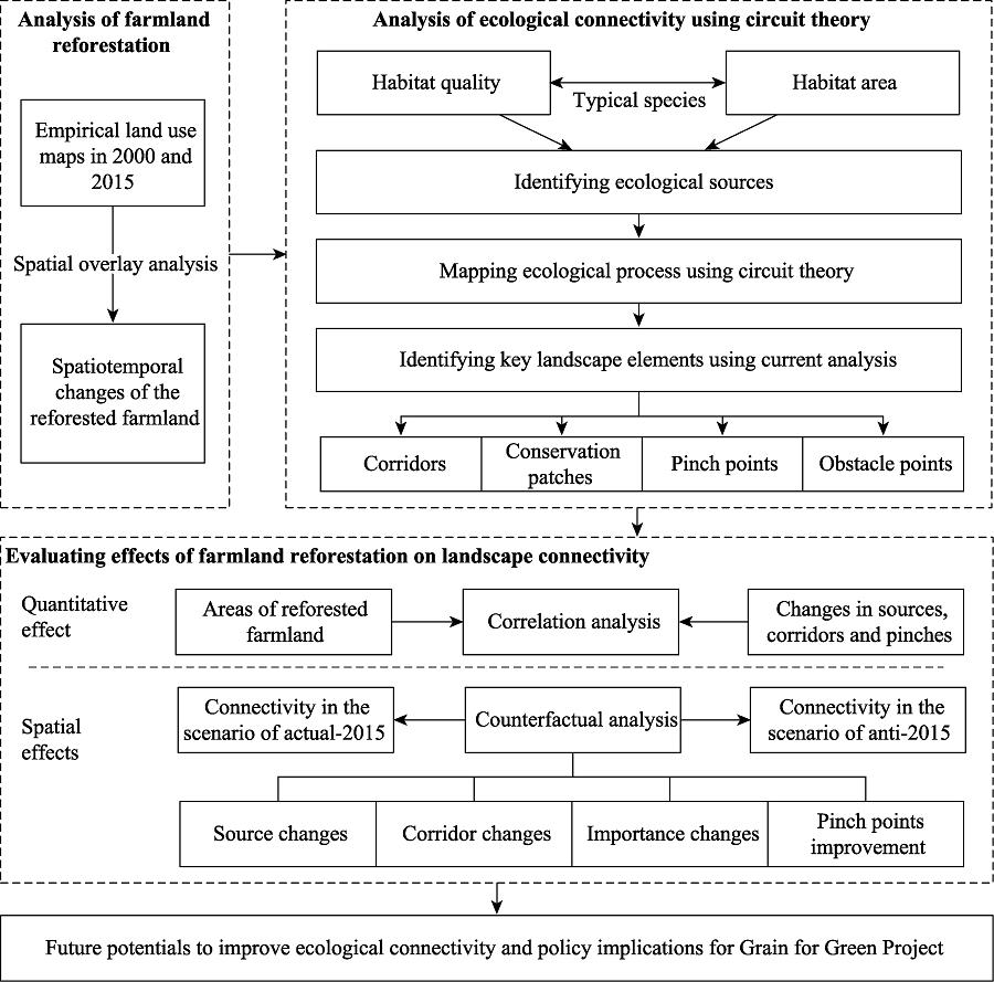
    Fig. 1. Analysis framework for evaluating the effect of farmland reforestation on ecological connectivity
    Location of the agro-pastoral ecotone of northern China
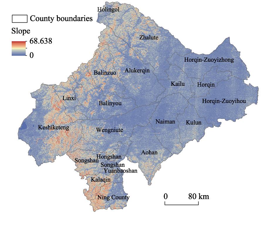
    Fig. 2. Location of the agro-pastoral ecotone of northern China
    A diagram showing circuit theory for landscape connectivity
    Fig. 3. A diagram showing circuit theory for landscape connectivity
    Reforested farmland during the period 2000-2015 (a. spatial pattern; b. reforested area and reforestation rate in each county)
    Fig. 4. Reforested farmland during the period 2000-2015 (a. spatial pattern; b. reforested area and reforestation rate in each county)
    Spatial distribution of ecological sources and key conservation areas (a and b. sources in 2000 and 2015; c and d. key areas in 2000 and 2015)
    Fig. 5. Spatial distribution of ecological sources and key conservation areas (a and b. sources in 2000 and 2015; c and d. key areas in 2000 and 2015)
    Spatial pattern of ecological corridors and obstacles (a and b. corridors in 2000 and 2015; c and d. obstacles and the occupation of land use types in 2015)
    Fig. 6. Spatial pattern of ecological corridors and obstacles (a and b. corridors in 2000 and 2015; c and d. obstacles and the occupation of land use types in 2015)
    Spatial distribution of pinch points (a. 2000; b. 2015)
    Fig. 7. Spatial distribution of pinch points (a. 2000; b. 2015)
    Correlations of farmland reforestation and ecological connectivity
    Fig. 8. Correlations of farmland reforestation and ecological connectivity
    Comparison of the actual and counterfactual scenarios in terms of ecological sources, corridors, pinch points and patch importance (Type I: unchanged importance; Type II: upgraded importance; Type III: downgraded importance; Type IV: gain of important patches; and Type V: loss of important patches)
    Fig. 9. Comparison of the actual and counterfactual scenarios in terms of ecological sources, corridors, pinch points and patch importance (Type I: unchanged importance; Type II: upgraded importance; Type III: downgraded importance; Type IV: gain of important patches; and Type V: loss of important patches)
    ThreatsMax distance/kmWeightDecay function
    Cultivated land80.7Linear
    Water70.5Exponential
    Built-up land121.0Exponential
    Unused land80.8Linear
    Table 1.

    Ecological threat factors

    Land use typeHabitatCultivated landWaterBuilt-up landUnused land
    Cultivated landNo0000
    ForestlandYes0.700.300.800.70
    ShrublandYes0.600.400.700.65
    Open forestland*Yes0.600.400.600.70
    Grass landNo0000
    Water areasNo0000
    Built-up landNo0000
    Barren areasNo0000
    Table 2.

    Sensitivity of land use types to threat factors

    CountiesReforested areaSource increaseCorridor increasePinch increase
    Aohan320.9823.9129.711.65
    Horqin-Zuoyizhong225.450.000.640.00
    Naiman187.315.364.090.14
    Horqin-Zuoyihou157.290.010.660.09
    Kulun153.140.004.430.72
    Zhalute141.3172.131.050.14
    Keshiketeng132.2070.888.500.01
    Wengniute131.3318.8417.020.46
    Songshan117.1228.4916.041.17
    Balinzuo83.4930.201.610.00
    Kailu78.924.120.270.26
    Horqin72.940.000.360.00
    Alukerqin68.3818.322.300.01
    Kalaqin59.6427.591.560.06
    Ning County57.916.001.010.07
    Linxi41.2920.587.020.02
    Balinyou40.4413.661.440.00
    Yuanbaoshan17.661.461.590.21
    Hongshan7.460.000.130.00
    Holingol0.140.000.000.00
    Table 3.

    Changes in ecological connectivity after reforestation in different counties (km2)

    Xiaojing LIU, Dianfeng LIU, Hongzhuo ZHAO, Jianhua HE, Yaolin LIU. Exploring the spatio-temporal impacts of farmland reforestation on ecological connectivity using circuit theory: A case study in the agro-pastoral ecotone of North China[J]. Journal of Geographical Sciences, 2020, 30(9): 1419
    Download Citation