• Spectroscopy and Spectral Analysis
  • Vol. 42, Issue 2, 524 (2022)
Location map of study area and Hyperion false color image
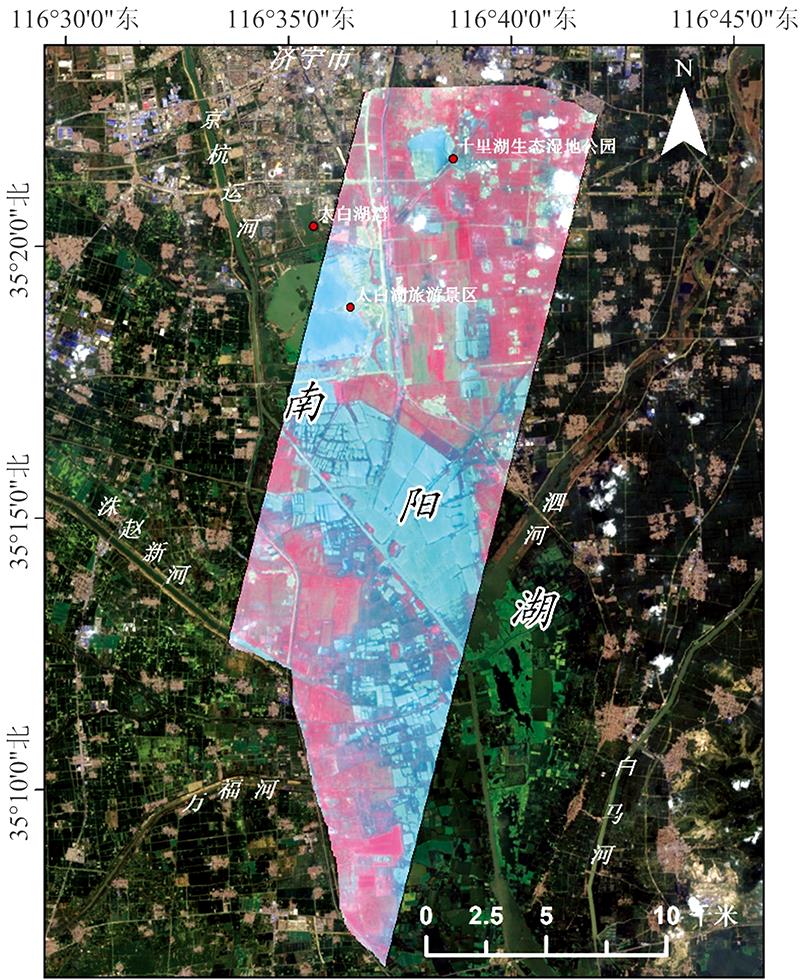
Fig. 1. Location map of study area and Hyperion false color image
The reflectance spectra of different landscapes
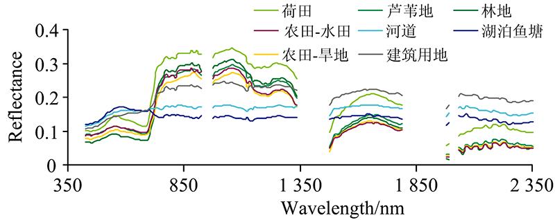
Fig. 2. The reflectance spectra of different landscapes
Standard deviation curves of spectral reflectance of different landscapes
Fig. 3. Standard deviation curves of spectral reflectance of different landscapes
First derivative spectra of different landscapes
Fig. 4. First derivative spectra of different landscapes
Standard deviations of first derivative spectra of different landscapes
Fig. 5. Standard deviations of first derivative spectra of different landscapes
NDVI series remote sensing indexes and EVI of different landscapes
Fig. 6. NDVI series remote sensing indexes and EVI of different landscapes
GI, MCARI/OSAVI, MSR705, Chlorphyll Index RedEdge 710 indexes of different landscapes
Fig. 7. GI, MCARI/OSAVI, MSR705, Chlorphyll Index RedEdge 710 indexes of different landscapes
地物类型像元数量面要素线要素点要素
荷田1932/600/0133
芦苇地1771/420/0135
林地2811/2790/02
农田-水田2 0504/2 0500/00
农田-旱地2 93110/2 9310/00
河道1830/00/0183
湖泊鱼塘2 0620/00/02 062
建筑用地4106/3881/220
Table 1. The number of pixels in the region of interest of each landscape type
植被指数计算公式文献
归一化植被指数NDVI(RNIR-RRed)/(RNIR+RRed)[15]
绿色归一化植被指数(GNDVI)(R801-R550)/(R800+R550)[16]
归一化植被指数1(NDVI1)(R760-R708)/(R760+R708)[17]
归一化植被指数2(NDVI2)(R800-R600)/(R800+R600)[18]
归一化植被指数3(NDVI3)(R900-R680)/(R900+R680)[19]
归一化植被指数4(NDVI4)(R780-R550)/(R780+R550)[20]
增强型植被指数(EVI)2.5×((RNIR-RRed)/(RNIR+6.0×RRed -7.5×RBlue+1))[21]
绿度指数(GI)R554/R677[22]
改进红边比值植被指数(MSR705)(R750-R445)/(R705+R445)[23]
优化土壤背景信息的综合叶绿素光谱
指数(MCARI/OSAVI)
[(R750-R705)-0.2(R750-R550)](R750/R705)/
[(1+0.16)(R750-R705)/(R750+R705+0.16)]
[24]
红边叶绿素指数710
(Chlorphyll Index RedEdge 710)
R750/R710-1[25]
Table 2. The Hyperspectral Vegetation indexes used by this work
湿地景观
类型
蓝边
/nm
蓝边
斜率
黄边
/nm
黄边
斜率
红边
/nm
红边
斜率
荷田517.928.70573.44-3.89712.1949.23
芦苇地509.144.77572.66-2.82719.2536.10
林地512.964.51570.25-3.33722.0443.63
农田-旱地510.574.66570.86-2.55719.7329.09
农田-水田507.855.03567.90-0.93721.8035.17
河道503.946.28565.772.21704.333.73
湖泊鱼塘506.667.16562.622.75708.03-5.49
建筑用地504.825.88570.561.92721.9715.76
Table 3. Characteristics of three sides (blue, yellow and red) of wetland landscape