• Journal of Natural Resources
  • Vol. 35, Issue 12, 2980 (2020)
Tao ZHENG1、2、3, Shuang CHEN1、*, Tong ZHANG1、2, Li-ting XU1、2, and Li-ya MA1、2
Author Affiliations
  • 1Nanjing Institute of Geography & Limnology, CAS, Nanjing 210008, China
  • 2University of Chinese Academy of Sciences, Beijing 100049, China
  • 3The Center for Modern Chinese City Studies, East China Normal University, Shanghai 200062, China
  • show less
    DOI: 10.31497/zrzyxb.20201213 Cite this Article
    Tao ZHENG, Shuang CHEN, Tong ZHANG, Li-ting XU, Li-ya MA. Research on driving mechanism of ecological land loss based on Bayesian network[J]. Journal of Natural Resources, 2020, 35(12): 2980 Copy Citation Text show less
    Location of the study area
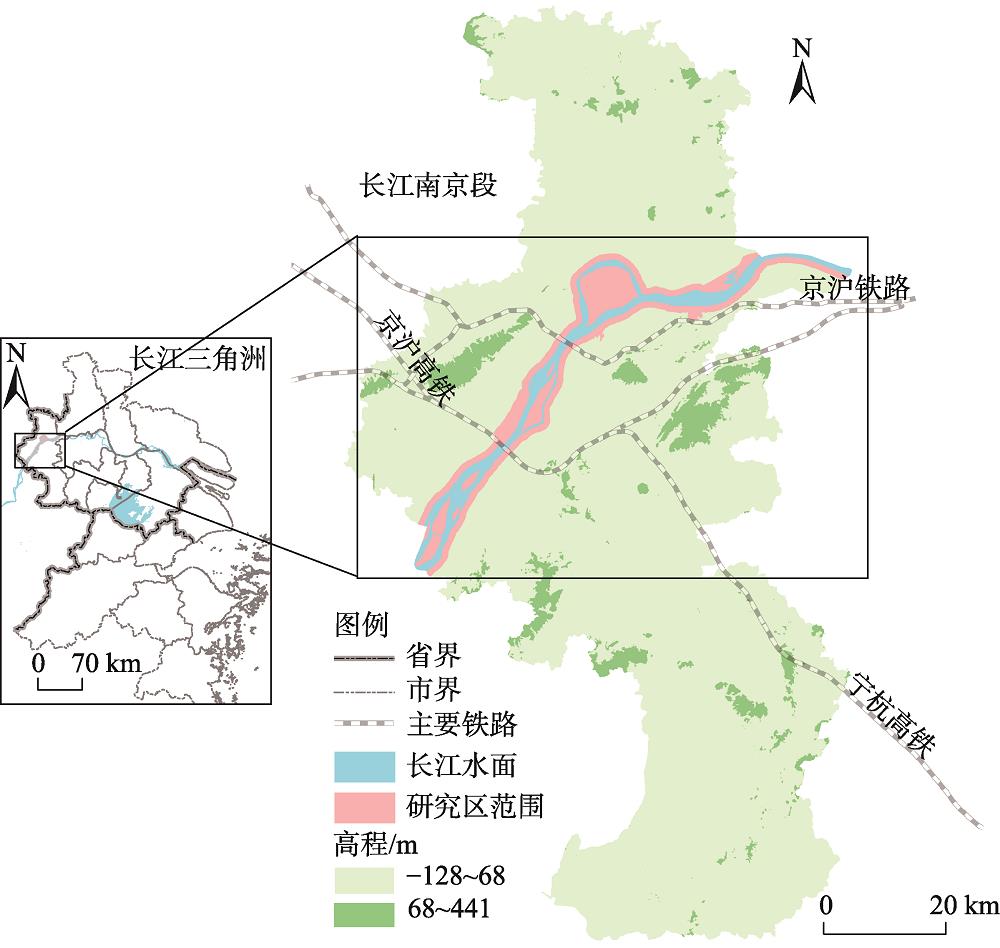
    Fig. 1. Location of the study area
    The spatial distribution of sample points
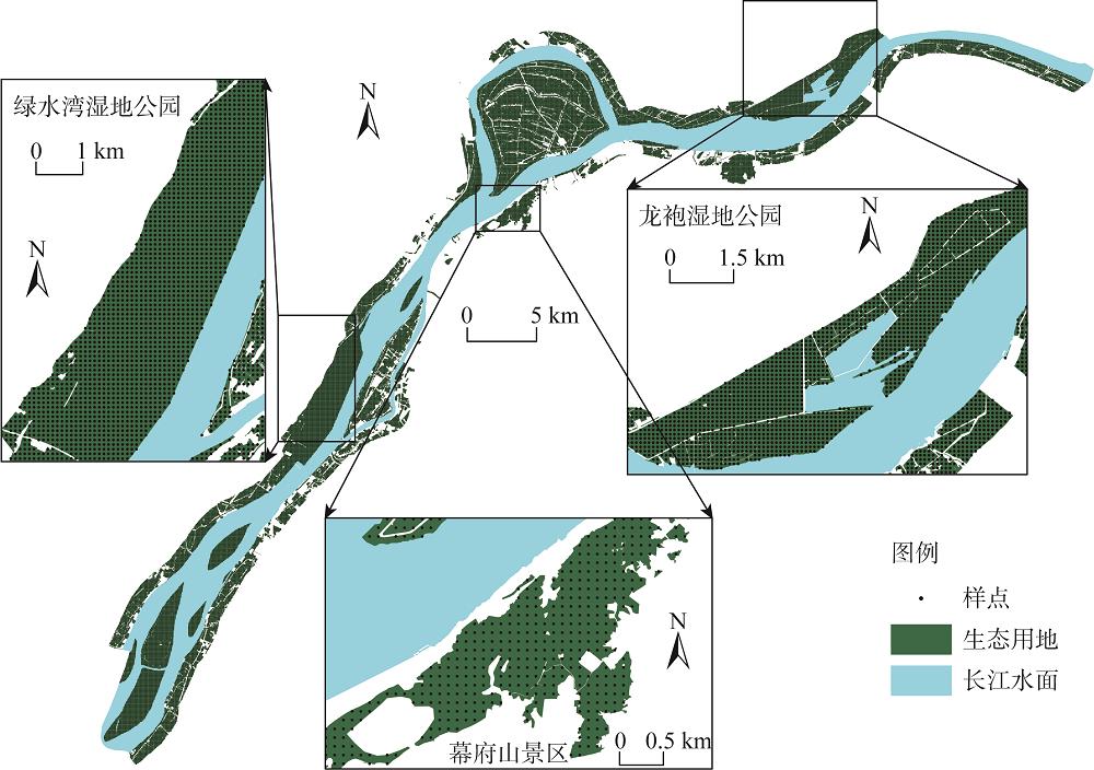
    Fig. 2. The spatial distribution of sample points
    Flowchart of Bayesian network model construction
    Fig. 3. Flowchart of Bayesian network model construction
    Boxplot of continuous variables
    Fig. 4. Boxplot of continuous variables
    The structure diagram of Bayesian network
    Fig. 5. The structure diagram of Bayesian network
    The training results of Bayesian network
    Fig. 6. The training results of Bayesian network
    Ecological land loss and industrial parks distribution along the Yangtze River in Nanjing between 2005-2018
    Fig. 7. Ecological land loss and industrial parks distribution along the Yangtze River in Nanjing between 2005-2018
    地类名称斑块数量/个面积最小值/m2面积最大值/m2平均面积/m2总面积/m2
    耕地7601010345189120419150952
    水域511100011995972923726333
    内陆滩涂 861033433536377643247727
    其他土地2201003384412201994443814
    园地359100210160981242916641
    林地 871022594058220 715158
    草地 7710035335110002 770180
    总计210010004335361189124970805
    Table 1. Characteristics of ecological land patches lost in 2005-2018
    因子层指标层
    邻域因子距主干道距离、距镇中心距离、距已开发地块距离、距工业园距离、城镇扩张惯性力
    自然因子高程、坡度、距长江水面距离、土地类型、开发阻力
    政策规划因子土地利用规划、沿江岸线规划、政策规划保护力
    目标变量生态用地流失概率
    Table 2. Drivers and indicators of ecological land loss
    变量名称数值类型等级代码
    1234567
    目标变量
    生态用地流失概率离散
    自变量
    邻域因子
    距主干道距离/m连续<10001000~20002000~4000>4000
    距镇中心距离/m连续<20002000~40004000~6000>6000
    距已开发地块距离/m连续<300300~600600~1200>1200
    距工业园距离/m连续<20002000~40004000~8000>8000
    城镇扩张惯性力离散
    自然因子
    高程/m连续<-50-50~00~50>50
    坡度/(°)连续0~22~55~15>15
    距长江水面距离/m连续<250250~500500~750>750
    土地类型离散耕地园地林地草地水域其他土地内陆滩涂
    开发阻力离散
    政策规划因子
    土地利用规划离散允许建设非允许建设
    沿江岸线规划离散生态生活生产其他
    政策规划保护力离散
    Table 3. The classification of discrete variables
    节点名称方差缩减
    政策规划保护力9.37
    沿江岸线规划5.42
    城镇扩张惯性力2.53
    土地利用规划0.74
    距主干道距离0.43
    距已开发地块距离0.27
    距工业园距离0.27
    开发阻力0.21
    距镇中心距离0.17
    土地类型0.08
    距长江水面距离0.06
    坡度0.01
    高程0
    Table 4. Sensitivity to target variables (%)
    变量名称变量状态概率变化变量名称变量状态概率变化
    政策规划保护力+3.6城镇扩张惯性力-2.4
    -3.6+2.4
    沿江岸线规划生态+3.1距主干道距离/m<1000-0.7
    生活-1.71000~2000-0.2
    生产-1.22000~4000+0.7
    其他-0.2>4000+0.3
    土地利用规划允许建设-1.0距已开发地块距离/m<300-0.7
    非允许建设+1.1300~600+0.1
    开发阻力+0.7600~1200+0.3
    -0.7>1200+0.3
    土地类型耕地-0.3距工业园距离/m<2000-0.4
    园地02000~4000-0.3
    林地+0.14000~8000+0.5
    草地0.0>8000+0.2
    水域-0.1距镇中心距离/m<2000-0.4
    其他土地02000~4000-0.1
    内陆滩涂+0.34000~6000+0.3
    >6000+0.1
    Table 5. Diagnostic analysis results (%)
    Tao ZHENG, Shuang CHEN, Tong ZHANG, Li-ting XU, Li-ya MA. Research on driving mechanism of ecological land loss based on Bayesian network[J]. Journal of Natural Resources, 2020, 35(12): 2980
    Download Citation