[1] X M Tang, G Y Li. Development and prospect of laser altimetry satellite. Space International, 13-18(2017).
[2] Seidleck M. The ice, cloud, l elevation satellite2—Overview, science, applications[C]2018 IEEE Aerospace Conference. IEEE, 2018: 18.
[3] X M Tang, G Y Li. Thoughts about land and sea satellite laser altimetry. Aerospace Shanghai, 36, 15-19(2019).
[4] M Mcgill, T Markus, V S Scott, et al. The Multiple Altimeter Beam Experimental Lidar (MABEL): An airborne simulator for theICESat-2 mission. Journal of Atmospheric & Oceanic Technology, 30, 345-352(2013).
[5] Magruder L A, Wharton M E, Stout K D, et al. Noise filtering techniques f photoncounting LADAR data[C]Proceedings of SPIE, 2012, 8379: 83790Q.
[6] Neumann T A, Brenner A, Hancock D, et al. ATLASICESat2 L2A global geolocated photon data, version 3, NASA National Snow Ice Data Center Distributed Active Archive Center, Boulder, CO, USA[DBOL]. (20201111)[2021−12−06]. https:doi.g10.5067ATLASATL03.003.
[7] D Gwenzi, M A Lefsky, V P Suchdeo, et al. Prospects of the ICESat-2 laser altimetry mission for savanna ecosystem structural studies based on airborne simulation data. ISPRS Journal of Photogrammetry & Remote Sensing, 118, 68-82(2016).
[8] Neuenschwer A L, Pitts K L, Jelley B P, et al. ATLASICESat2 L3 A l vegetation height, version 3, NASA National Snow Ice, Boulder, CO, USA[DBOL]. (20211111)[2021−12−06]. https:nsidc.gdataATL08versions3.
[9] Y T Xu, G Y Li, C X Qiu, . Single photon laser data processing technology based on Terrain Correlation and least square curve fitting. Infrared and Laser Engineering, 48, 1205004(2019).
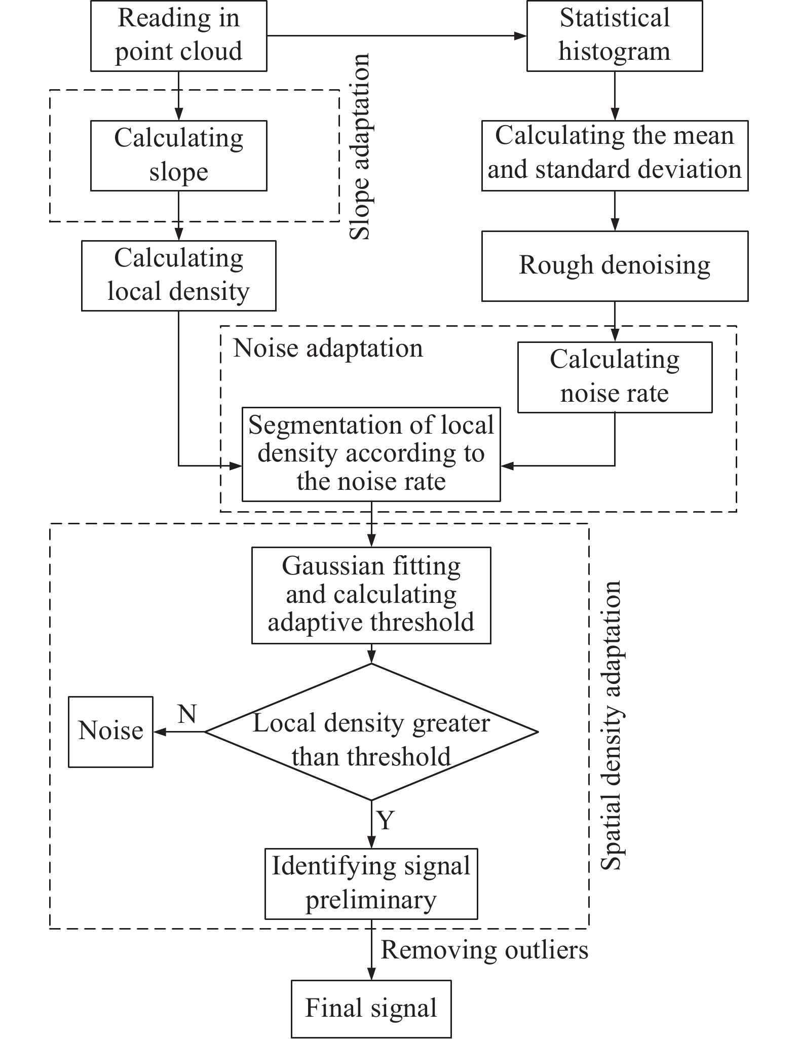
[10] B C Cao, Y Fang, Z Z Jiang, . Single photon laser point cloud denoising algorithm based on adaptive spatial density. Geomatics Sciecce and Engineering, 39, 13-17(2019).
[11] J Zhang, J Kerekes. An adaptive density-based model for extracting surface returns from photon-counting laser altimeter data. IEEE Geoscience and Remote Sensing Letters, 12, 726-730(2014).
[12] F Xie, G Yang, R Shu, . An adaptive directional filter for photon counting Lidar point cloud data. Journal of Infrared and Millimeter Waves, 36, 107-113(2017).
[13] S B Xia, C Wang, X H Xi, et al. Point cloud filtering and tree height estimation using airborne experiment data of ICESat-2. Journal of Remote Sensing, 18, 1199-1207(2014).
[14] J S Zhang, J P Kerekes. First-principle simulation of spaceborne micropulse photon-counting lidar performance on complex surfaces. IEEE Transactions on Geoscience & Remote Sensing, 52, 6488-6496(2014).
[15] R Kwok, T Markus, J Morison, et al. Profiling sea ice with a multiple altimeter beam experimental lidar (MABEL). Journal of Atmospheric & Oceanic Technology, 31, 1151-1168(2014).
[16] S Nie, C Wang, X Xi, et al. Estimating the vegetation canopy height using micro-pulse photon-counting LiDAR data. Optics Express, 26, A520-A540(2018).
[17] Y Wang, S Li, X Tian, . An adaptive directional model for estimating vegetation canopy height using space-borne photon counting laser altimetry data. Journal of Infrared and Millimeter Waves, 39, 363-371(2020).
[18] Z G Hong, N Cong, L Yan, et al. Three dimensional surface monitoring technology of ice and snow resources in Qinghai Tibet Plateau—a case study of Geladandong. Science of Surveying and Mapping, 37, 63-65(2012).
[19] L Y Zhang. Glaciers and their evolution in the source area of Tuotuo River in the upper reaches of the Yangtze River. Journal of Glaciology and Geocryology, 3, 1-9(1981).
[20] A Neuenschwander, K Pitts. The ATL08 land and vegetation product for the ICESat-2 Mission. Remote Sensing of Environment, 221, 247-259(2019).