• Journal of Geo-information Science
  • Vol. 22, Issue 3, 592 (2020)
Hui HUANG and Xinli KE*
Author Affiliations
  • College of Public Administration, Huazhong Agricultural University, Wuhan 430070, China
  • show less
    DOI: 10.12082/dqxxkx.2020.190414 Cite this Article
    Hui HUANG, Xinli KE. Demarcating of Permanent Prime Farmland for Synergy of Farmland Protection and Urban Expansion: A Case Study of Wuhan[J]. Journal of Geo-information Science, 2020, 22(3): 592 Copy Citation Text show less
    Land-use map of Wuhan in 2015
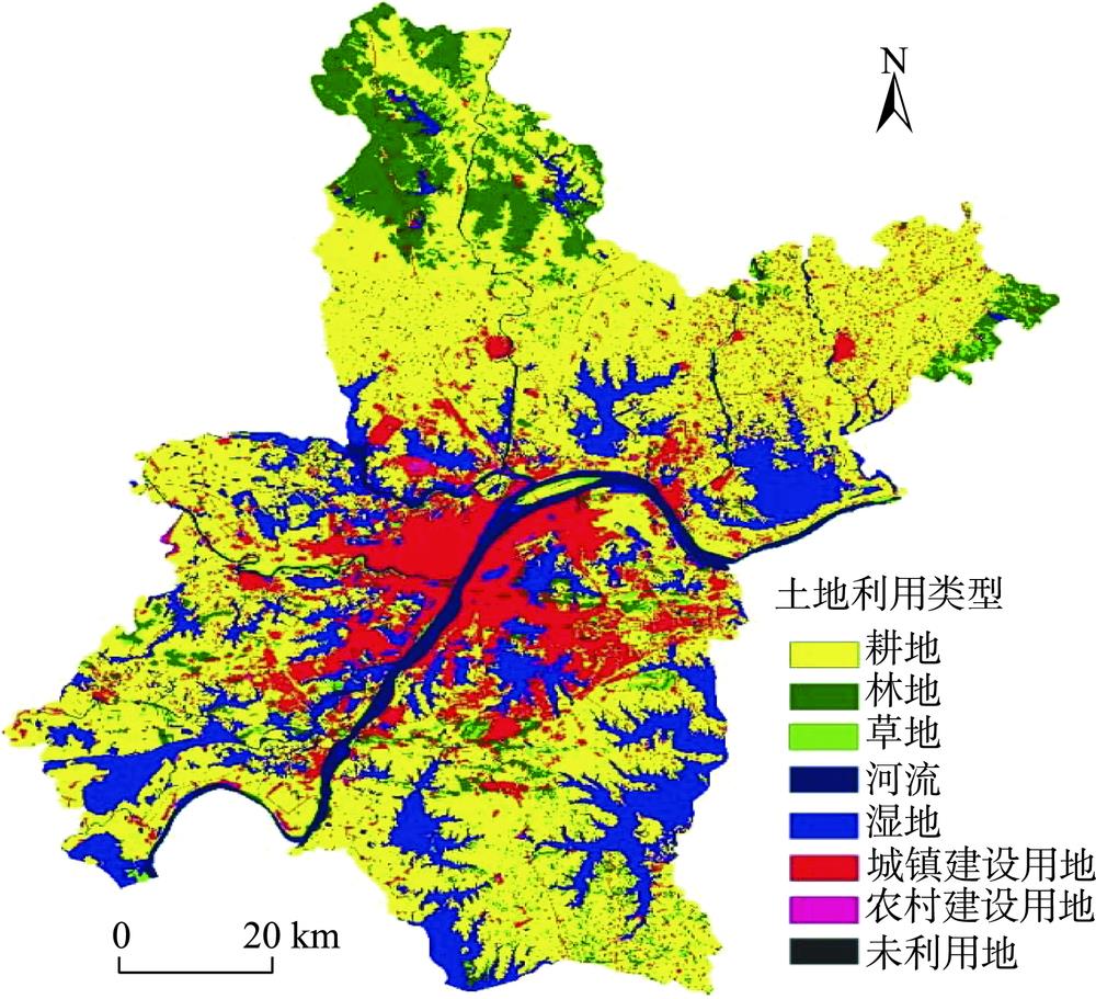
    Fig. 1. Land-use map of Wuhan in 2015
    Framework of the permanent prime farmland demarcation
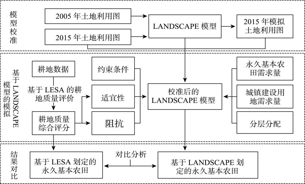
    Fig. 2. Framework of the permanent prime farmland demarcation
    Comprehensive quality classification of farmland in Wuhan
    Fig. 3. Comprehensive quality classification of farmland in Wuhan
    Permanent prime farmland demarcation based on LESA system in Wuhan
    Fig. 4. Permanent prime farmland demarcation based on LESA system in Wuhan
    Basic map for permanent prime farmland demarcation in Wuhan
    Fig. 5. Basic map for permanent prime farmland demarcation in Wuhan
    Permanent prime farmland demarcation in Wuhan based on LANDSCAPE model
    Fig. 6. Permanent prime farmland demarcation in Wuhan based on LANDSCAPE model
    LESA体系一级指标二级指标指标赋值标准权重
    10080604020
    耕地质量(LE)土壤条件有机质含量27.10~30.7924.90~27.123.00~24.9020.90~23.0016.70~20.900.19
    表层质地壤土粘壤土粘土砂土0.15
    pH值6.5~7.55.5~6.57.5~8.05.0~5.54.5~5.00.11
    地形条件坡度<22~1010~25≥250.12
    高程<31.1931.19~47.6947.69~76.5776.57~161.15>161.150.08
    基础设施条件灌溉条件充分满足基本满足不满足0.20
    排水条件充分满足基本满足不满足0.15
    立地条件(SA)区位条件到主干道距离/km≤0.50.5~1.01.0~1.51.5~2.0>2.00.19
    到水源距离/km≤0.50.5~1.01.0~1.51.5~2.0>2.00.18
    到居民点距离/km≤0.20.2~0.50.5~0.80.8~1.2>1.20.23
    空间形态连片度P=100(Si-Smin)/(Smax-Smin)0.16
    形状指数E=100(Ei-Emin)/(Emax-Emin)0.24
    Table 1. Indexes, assessment methods and weights of permanent prime farmland demarcation in Wuhan City
    耕地等级LESA综合分值/分耕地面积/km2比例/%
    I>75278.405.45
    II65~751699.3233.29
    III55~652161.4742.35
    IV45~55874.7717.14
    V<4590.161.77
    Table 2. LESA comprehensive score statistics and classification of farmland in Wuhan
    地类一般耕地林地草地河流湿地城镇建设用地农村建设用地未利用地永久基本农田
    面积197 50970 359499528 472129 843160 00021 252256243 200
    城市扩张占用面积19 37268732928026 373-4 1813440
    新划入的永久基本农田面积215 3600000000-
    Table 3. Results of permanent prime farmland demarcation simulation in Wuhan (hm2)
    县域耕地地力等级LESA方法划定LANDSCAPE方法划定
    农田面积/hm2比例/%农田面积/hm2比例/%
    146 51522.6745 15722.58
    221 46410.4621 18910.59
    325 62212.4925 19412.60
    440 36719.6836 45318.22
    535 54417.3334 48317.24
    Table 4. Comparison of quality grade of permanent prime farmland demarcated based on two methods
    永久基本农田划分方法斑块数量/个平均斑块面积/hm2破碎度平均斑块分维数面积加权平均形状因子
    LESA3072156.121.2566E-061.28451.2180
    LANDSCAPE1457317.665.9885E-071.24731.1540
    Table 5. Comparison of landscape index of permanent prime farmland demarcated based on two methods
    Hui HUANG, Xinli KE. Demarcating of Permanent Prime Farmland for Synergy of Farmland Protection and Urban Expansion: A Case Study of Wuhan[J]. Journal of Geo-information Science, 2020, 22(3): 592
    Download Citation