• Acta Optica Sinica
  • Vol. 39, Issue 1, 0104002 (2019)
Lin Gao1、2、*, Weidong Song1、*, Hai Tan2, and Yang Liu1、2
Author Affiliations
  • 1 School of Mapping and Geographical Science, Liaoning Technical University, Fuxin, Liaoning 123000, China
  • 2 Satellite Surveying and Mapping Application Center, National Administration of Surveying, Mapping and Geoinformation, Beijing 100048, China
  • show less
    DOI: 10.3788/AOS201939.0104002 Cite this Article Set citation alerts
    Lin Gao, Weidong Song, Hai Tan, Yang Liu. Cloud Detection Based on Multi-Scale Dilation Convolutional Neural Network for ZY-3 Satellite Remote Sensing Imagery[J]. Acta Optica Sinica, 2019, 39(1): 0104002 Copy Citation Text show less
    Convolution kernel with different dilation rates. (a) r=1; (b) r=6; (c) r=12; (d) r=18
    Fig. 1. Convolution kernel with different dilation rates. (a) r=1; (b) r=6; (c) r=12; (d) r=18
    Schematic of deep multiscale dilation fully convolutional neural network architecture
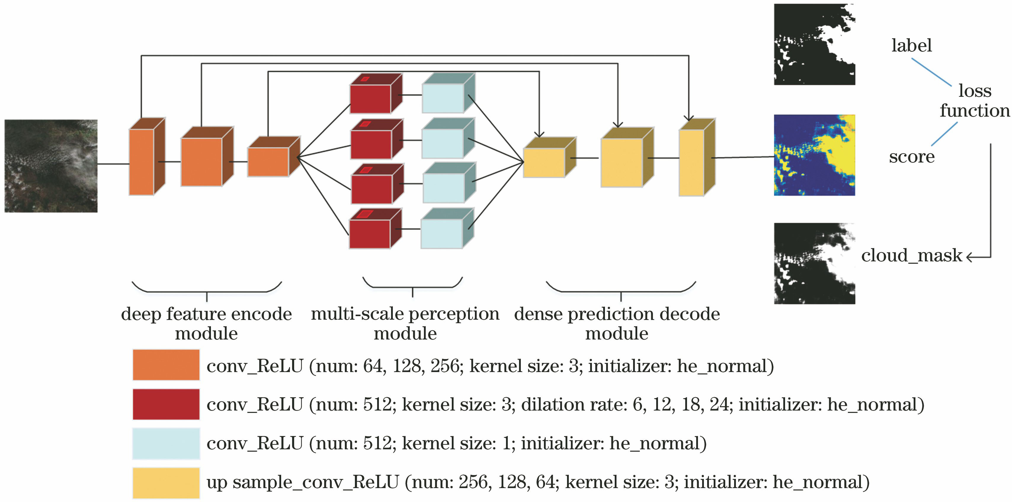
    Fig. 2. Schematic of deep multiscale dilation fully convolutional neural network architecture
    Visual analysis on cloud area for different pooling layers
    Fig. 3. Visual analysis on cloud area for different pooling layers
    Diagram of edge protection of training image
    Fig. 4. Diagram of edge protection of training image
    Comparison of cloud detection results at different areas using different algorithms. (a) Area covered by thick cloud; (b) area covered by middle-thick cloud; (c) area covered by thick and thin clouds; (d) area covered by thick cloud and haze with the a complex scene; (e) area covered by a large range of thick cloud
    Fig. 5. Comparison of cloud detection results at different areas using different algorithms. (a) Area covered by thick cloud; (b) area covered by middle-thick cloud; (c) area covered by thick and thin clouds; (d) area covered by thick cloud and haze with the a complex scene; (e) area covered by a large range of thick cloud
    IndexParameter
    Resolution /m5.8
    Wavelength /nmBand 1: 450-520; Band 2: 520-590
    Band 3: 630-690; Band 4: 770-890
    Width /km52
    Single scene /km22704
    Latitude rangeupper left:30.5633N; upper right: 30.4678N
    lower left: 30.1186N; lower right: 30.0234N
    Longitude rangeupper left: 113.7162E; upper right: 114.2382E
    lower left: 113.6103E; lower right: 114.1299E
    Table 1. Multi-spectral image parameters of ZY-3 satellite
    MethodAccuracy /%Training time /h
    FCN-8S86.936
    Proposed96.814
    Table 2. Comparison of the accuracy of different network structures
    Fig.Detection algorithmOADOAF1-measureKappaDKappa
    Otsu0.9444-0.04580.96680.7990-0.1687
    Fig. 5(a)FCN-8S0.9661-0.02410.97930.8867-0.081
    Proposed0.99020.99360.9677
    Otsu0.8413-0.08950.84120.6869-0.1705
    Fig. 5(b)FCN-8S0.9096-0.02120.91500.8189-0.0385
    Proposed0.93080.94160.8574
    Otsu0.8580-0.10750.88370.7075-0.2106
    Fig. 5(c)FCN-8S0.8841-0.08140.90760.7544-0.1637
    Proposed0.96550.97550.9181
    Otsu0.9731-0.01460.98550.8100-0.0686
    Fig. 5(d)FCN-8S0.9789-0.00690.98860.8440-0.0346
    Proposed0.98580.99280.8786
    Otsu0.7649-0.22750.12770.0987-0.6152
    Fig. 5(e)FCN-8S0.9767-0.01570.53860.5279-0.0186
    Proposed0.99240.71750.7139
    Table 3. Quantity evaluation parameters of different algorithms
    Lin Gao, Weidong Song, Hai Tan, Yang Liu. Cloud Detection Based on Multi-Scale Dilation Convolutional Neural Network for ZY-3 Satellite Remote Sensing Imagery[J]. Acta Optica Sinica, 2019, 39(1): 0104002
    Download Citation