• Infrared and Laser Engineering
  • Vol. 50, Issue 12, 20210112 (2021)
Leiguang Wang1、2, Ruozheng Geng3, Qinling Dai4, Jun Wang3, Chen Zheng5、*, and Zhitao Fu6
Author Affiliations
  • 1Institutes of Big Data and Artificial Intelligence, Southwest Forestry University, Kunming 650224, China
  • 2Key Laboratory of National Forestry and Grassland Administration on Forestry and Ecological Big Data, Southwest Forestry University, Kunming 650224, China
  • 3Forestry College, Southwest Forestry University, Kunming 650224, China
  • 4College of Art and Design, Southwest Forestry University, Kunming 650224, China
  • 5College of Mathematics and Statistic, Henan University, Kaifeng 475004, China
  • 6Faculty of Land and Resources Engineering, Kunming University of Science and Technology, Kunming 650093, China
  • show less
    DOI: 10.3788/IRLA20210112 Cite this Article
    Leiguang Wang, Ruozheng Geng, Qinling Dai, Jun Wang, Chen Zheng, Zhitao Fu. Conditional random field classification method based on hyperspectral-LiDAR fusion[J]. Infrared and Laser Engineering, 2021, 50(12): 20210112 Copy Citation Text show less
    Hyperspectral and LiDAR co-classification by CRF integrating feature dissimilarity and class co-occurrence
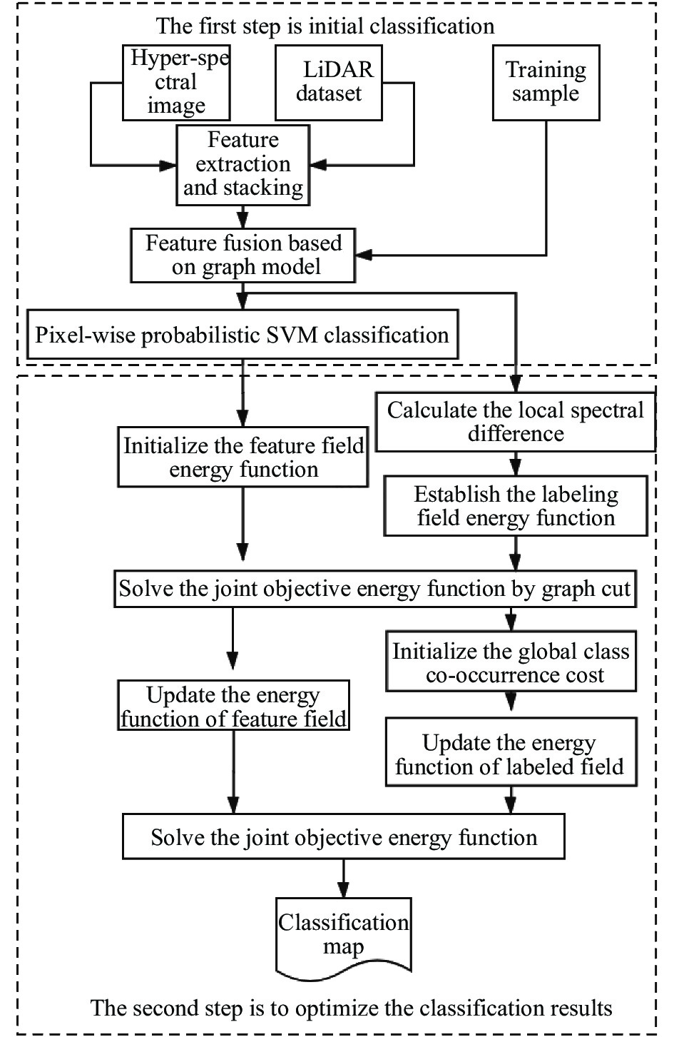
    Fig. 1. Hyperspectral and LiDAR co-classification by CRF integrating feature dissimilarity and class co-occurrence
    Houston data set
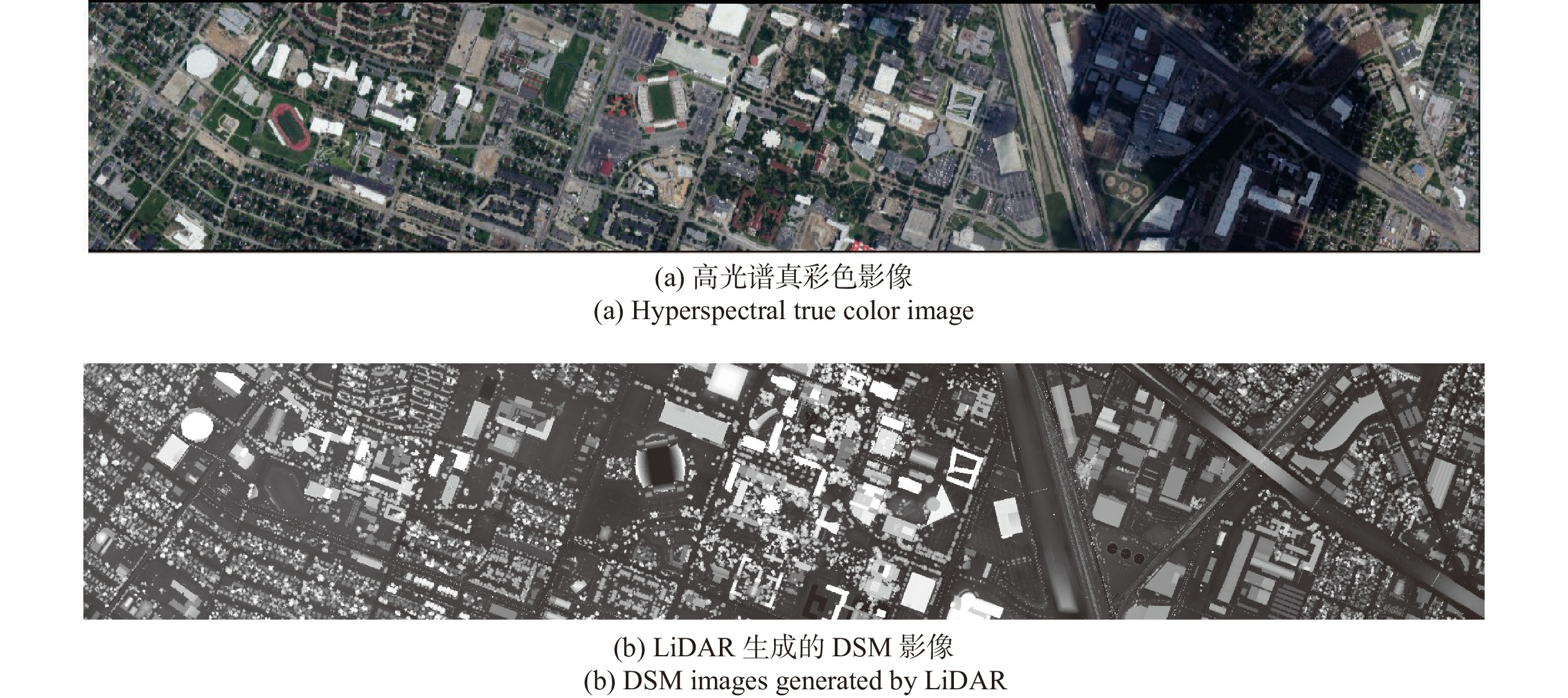
    Fig. 2. Houston data set
    Gaofeng forest farm data set
    Fig. 3. Gaofeng forest farm data set
    Classification results obtained from different feature fusion settings in the shaded area (Houston data set)
    Fig. 4. Classification results obtained from different feature fusion settings in the shaded area (Houston data set)
    Initial classification map and results optimized by different CRF methods (Houston data set)
    Fig. 5. Initial classification map and results optimized by different CRF methods (Houston data set)
    (a) 休斯顿 (a) Houston (b) 高峰林场 (b) Gaofeng forest farm
    Class nameNumber of training/testing samples/pixelSample colorClass nameNumber of training/testing samples/pixelSample color
    Healthy grass198/1053Eucalyptus193/315
    Stressed grass190/1064Road74/106
    Synthetic grass192/505Tilia tuan40/52
    Trees188/1056Cultivated land95/127
    Soil186/1056Acacia crassicarpa benth208/308
    Water182/143Wasteland16/20
    Residential196/1072Michelia macclurei dandy69/95
    Commercial191/1053Building165/251
    Road193/1059Other broad leaved forests184/275
    Highway191/1036Pinus massoniana lamb214/300
    Railway181/1054Cunninghamia lanceolata34/47
    Parking Lot 1192/1041Water390/562
    Parking Lot 2184/285Mixed shrub forest53/84
    Tennis court181/247Bamboo21/34
    Running track187/473Grassland23/20
    Table 1. Class names and their numbers
    Precisionβ
    0.511.522.533.544.5
    OA93.99%94.00%93.93%93.88%93.89%93.86%93.8593.84%93.83%
    Kappa0.9350.9350.9340.9330.9340.9330.9330.9330.933
    AA93.47%93.42%93.19%93.07%91.30%93.06%93.04%93.04%93.03%
    Table 2. Influence of different β values on the final classification accuracy (Houston)
    (a) 休斯顿数据集 (a) Houston data set
    CategoryPixel level classification methodCRF classification optimization method
    FSpeFDSMFSpe+FSpaFSpe+FDSMGGFGGF_CRF1GGF-CRF
    Healthy grass82.3424.8855.6955.8981.6782.4383.1
    Stressed grass83.3655.9284.4084.4999.3499.6299.81
    Synthetic grass10091.88100100100100100
    Trees93.3767.2391.5798.1199.2499.2499.62
    Soil98.3076.8010099.15100100100
    Water91.6180.4299.3096.5095.1095.1094.41
    Residential76.5971.7482.8491.3292.3592.2693.47
    Commercial56.5161.9253.0952.4294.5994.7895.73
    Road66.5751.3779.0483.9586.0285.9385.74
    Highway72.3953.8668.1579.9293.2493.6394.98
    Railway92.8883.9797.3487.7690.7090.8090.61
    Parking Lot 178.5860.7197.7079.6394.2494.4397.41
    Parking Lot 272.9857.1981.0574.0472.2871.9366.67
    Tennis Court98.7997.1710098.79100100100
    Running Track98.3128.9698.5297.6799.3799.3799.79
    OA81.98%60.48%85.12%85.14%93.34%93.47%94.00%
    AA84.17%64.27%85.91%85.31%93.21%93.30%93.42%
    Kappa0.8050.5970.8390.8390.9280.9290.935
    (b)高峰林场数据集 (b) Gaofeng forest farm data set
    CategoryPixel level classification methodCRF classification optimization method
    FSpeFDSMFSpe+FSpaFSpe+FDSMGGFGGF_CRF1GGF-CRF
    Eucalyptus73.6560.6390.7977.4686.6796.8297.14
    Road48.1152.8390.5766.9874.5373.5073.58
    Tilia tuan5.7746.1559.6253.852532.6932.69
    Cultivated land83.4698.4310096.85100100100
    Acacia crassicarpa benth71.7588.3197.0887.6690.9197.7397.73
    Wasteland8055959095100100
    Michelia macclurei dandy31.5855.7975.7970.5367.3783.1684.24
    Building83.2784.0696.4192.8398.0197.2197.21
    Other broad leaved forests70.9166.5596.3665.8283.2785.4585.82
    Pinus massoniana lamb73.6792.6792.0085.6789.0096.6797.00
    Cunninghamia lanceolata12.7768.0995.7465.9678.7295.7495.74
    Water99.8298.2210099.64100100100
    Mixed shrub forest2.3851.1973.8167.8673.8188.188.1
    Bamboo02.9417.6517.65000
    Grassland10.0040.0055.0085.0095.00100100
    OA71.46%78.58%92.41%83.32%87.71%92.37%92.84%
    AA49.81%64.06%82.39%74.92%77.15%83.14%83.28%
    Kappa0.6740.7560.9140.8110.8600.9130.919
    Table 3. Producer's accuracy comparison of seven classification methods for different data sets
    PrecisionDeep fusion[15]HyMCKs[8]Multi level fusion method[4]EC-CRF[11]GGF-CRF
    OA91.32%90.33%93.22%91.70%94.00%
    Kappa0.90570.89490.9300.9070.935
    Table 4. Comparison of classification accuracy of different methods on Houston data set
    Leiguang Wang, Ruozheng Geng, Qinling Dai, Jun Wang, Chen Zheng, Zhitao Fu. Conditional random field classification method based on hyperspectral-LiDAR fusion[J]. Infrared and Laser Engineering, 2021, 50(12): 20210112
    Download Citation