[1] Cui H O, Liu M. Analysis on the results of the 9th national forest inventory[J]. Journal of West China Forestry Science, 49, 90-95(2020).
[2] Li Z Y, Chen E X. Development course of forestry remote sensing in China[J]. National Remote Sensing Bulletin, 25, 292-301(2021).
[3] Zhang L, Li B, Yang W J et al. Forest vegetation classification and its variation in Lushan Nature Reserve using Proba-V vegetation products[J]. Progress in Geography, 40, 703-712(2021).
[4] Yu L K, Yu Y, Liu X Y et al. Tree species classification with hyperspectral image[J]. Journal of Northeast Forestry University, 44, 40-43, 57(2016).
[6] Liu L J, Pang Y, Fan W Y et al. Fused airborne LiDAR and hyperspectral data for tree species identification in a natural temperate forest[J]. Journal of Remote Sensing, 17, 679-695(2013).
[8] Hu H Y, Hui Z Y, Li N. Airborne LiDAR point cloud classification based on multiple-entity eigenvector fusion[J]. Chinese Journal of Lasers, 47, 0810002(2020).
[9] Li D, Kong F Q, Zhu D Y. Hyperspectral image classification based on local Gaussian mixture feature extraction[J]. Acta Optica Sinica, 41, 0610001(2021).
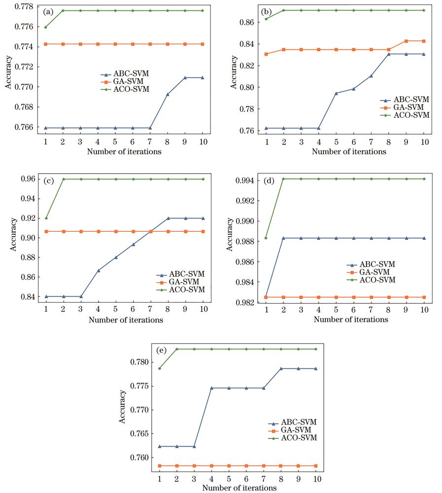
[10] Zhuang Y, Bai Z L, Xu Y F. Research on parameters of support vector machine based on antcolonyalgorithm[J]. Computer Simulation, 28, 216-219(2011).
[11] Fu Q, Guo C, Luo W L. A hyperspectral image classification method based on spectral-spatial features[J]. Laser & Optoelectronics Progress, 57, 202803(2020).
[13] Liu L, Kuang G Y. Overview of image textural feature extraction methods[J]. Journal of Image and Graphics, 14, 622-635(2009).
[15] Zhao Y, Wang H, Zhang Z Z. Forest healthy classification of robinia pseudoacaciain the Yellow River Delta, China based on spectral and spatial remote sensing variables using random forest[J]. Remote Sensing Technology and Application, 31, 359-367(2016).
[17] Zhao H W, Xie Y F, Cao B F et al. Extraction and application of froth texture feature based on Gabor wavelets and LPP in flotation process[J]. Journal of Shanghai Jiao Tong University, 48, 942-947(2014).
[19] Ye F M, Meng X L, Dong M et al. Remote sensing image retrieval with ant colony optimization and a weighted image-to-class distance[J]. Acta Geodaetica et Cartographica Sinica, 50, 612-620(2021).
[20] Niu M T. Research on forest type recognition method of UAV remote sensing image based on bee colony algorithm[D](2019).