• Laser & Optoelectronics Progress
  • Vol. 59, Issue 12, 1200002 (2022)
Yong Fang1、2、*, Hui Gong1、2, Li Zhang1、2, and Haiyan Hu1、2
Author Affiliations
  • 1Xi’an Research Institute of Surveying and Mapping, Xi’an 710054, Shaanxi , China
  • 2State Key Laboratory of Geo-Information Engineering, Xi’an 710054, Shaanxi , China
  • show less
    DOI: 10.3788/LOP202259.1200002 Cite this Article Set citation alerts
    Yong Fang, Hui Gong, Li Zhang, Haiyan Hu. From Global Laser Point Cloud Acquisition to 3D Digital Geospatial Framework: The Advanced Road of Global Accurate Mapping[J]. Laser & Optoelectronics Progress, 2022, 59(12): 1200002 Copy Citation Text show less
    Setup diagram of 3D digital geospatial information framework based on global laser point cloud
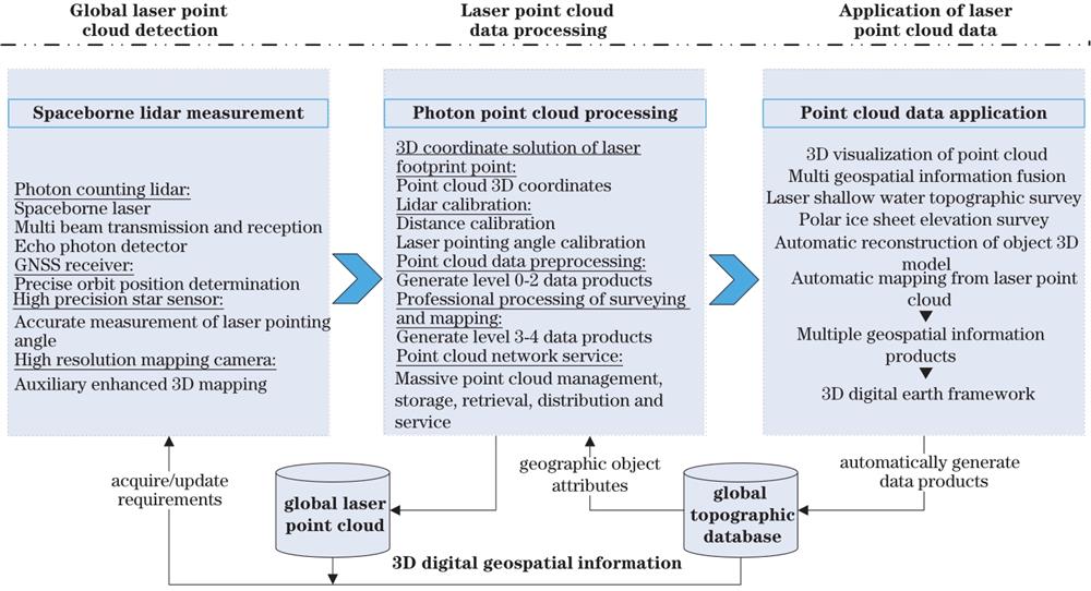
    Fig. 1. Setup diagram of 3D digital geospatial information framework based on global laser point cloud
    ConditionLiDARInSAROptical stereo
    All-time
    All-weather
    Good visual performance
    High-resolution
    High plane positioning accuracy
    High elevation positioning accuracy
    High relative positioning accuracy
    Automatic rapid mapping processing
    Polar/glacial mapping
    Timely/widely covered
    Table 1. Comparison of spaceborne three-dimensional remote sensing surveying and mapping methods
    Yong Fang, Hui Gong, Li Zhang, Haiyan Hu. From Global Laser Point Cloud Acquisition to 3D Digital Geospatial Framework: The Advanced Road of Global Accurate Mapping[J]. Laser & Optoelectronics Progress, 2022, 59(12): 1200002
    Download Citation