• Infrared and Laser Engineering
  • Vol. 51, Issue 2, 20210896 (2022)
Xueqi Chen1、2, Minjie Wan1、2、*, Yunkai Xu1、2, Weixian Qian1、2, Qian Chen1、2, and Guohua Gu1、2、*
Author Affiliations
  • 1School of Electronic and Optical Engineering, Nanjing University of Science and Technology, Nanjing 210094, China
  • 2Jiangsu Key Laboratory of Spectral Imaging & Intelligent Sense, Nanjing University of Science and Technology, Nanjing 210094, China
  • show less
    DOI: 10.3788/IRLA20210896 Cite this Article
    Xueqi Chen, Minjie Wan, Yunkai Xu, Weixian Qian, Qian Chen, Guohua Gu. Infrared remote sensing imaging simulation method for earth’s limb scene[J]. Infrared and Laser Engineering, 2022, 51(2): 20210896 Copy Citation Text show less
    Schematic diagram of midpoint displacement
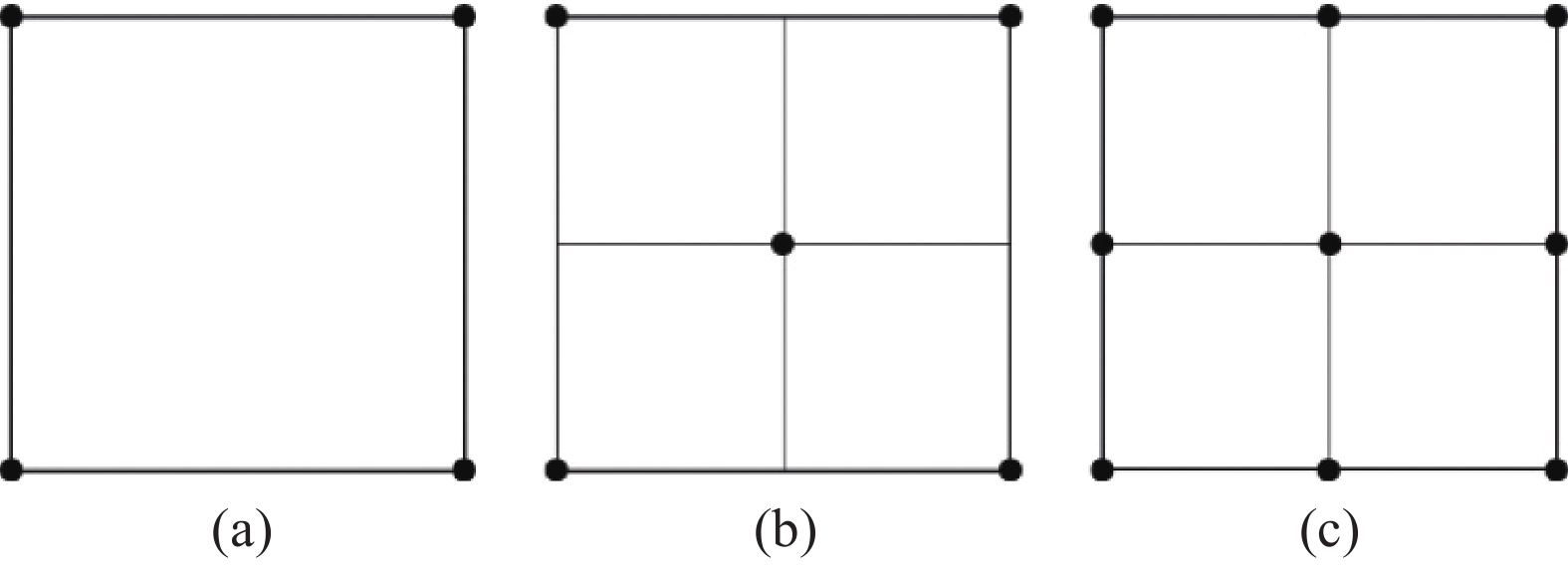
    Fig. 1. Schematic diagram of midpoint displacement
    Schematic diagram of infrared image simulation of earth limb scene
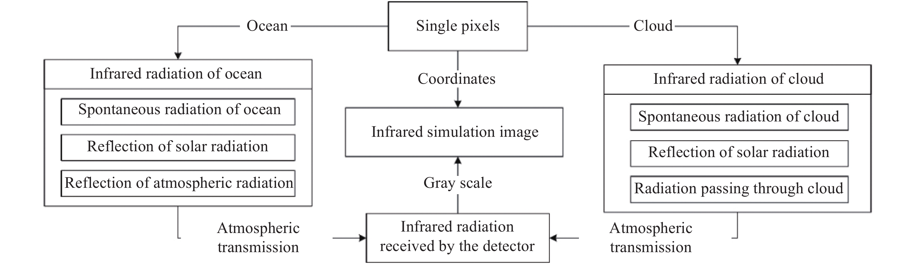
    Fig. 2. Schematic diagram of infrared image simulation of earth limb scene
    Schematic diagram of transformation between coordinate systems
    Fig. 3. Schematic diagram of transformation between coordinate systems
    Schematic diagram of infrared simulation effect of earth limb scene (Without noise)
    Fig. 4. Schematic diagram of infrared simulation effect of earth limb scene (Without noise)
    Schematic diagram of infrared simulation effect of earth limb scene (Including noise)
    Fig. 5. Schematic diagram of infrared simulation effect of earth limb scene (Including noise)
    Parameters(a)(b)(c)(d)(e)(f)(g)(h)(i)(j)(k)(l)
    Focal length/mm202020204040404060606080
    Obliquity of satellite orbit/rad000020202020020020
    Altitude of satellite orbit/km2 0002 0002 0002 00010 00010 00010 00010 00020 00020 00020 00020 000
    Longitude of virtual target/rad5π/125π/127π/127π/125π/125π/127π/127π/125π/125π/127π/127π/12
    Latitude of virtual target/radπ/18π/6π/18π/6π/18π/6π/18π/6π/18π/6π/18π/6
    Altitude of virtual target/km1002002002005005003 0003 0002002005 0005 000
    Longitude of direct sunlight/rad02π/34π/302π/34π/302π/34π/302π/34π/3
    Latitude of direct sunlight/rad−π/9−π/9−π/9000π/9π/9π/9−π/90π/9
    Table 1. Simulation parameters
    Evaluation index image in figures LSGMGRuntime/s
    Fig.4Fig.5Fig.4Fig.5
    (a)0.0850.0780.340.3398.57
    (b)0.0900.0800.440.4098.71
    (c)0.110.100.500.50164.22
    (d)0.130.110.710.6187.30
    (e)0.130.120.580.53105.50
    (f)0.140.120.630.57111.58
    (g)0.170.150.810.76154.30
    (h)0.160.150.850.77108.92
    (i)0.220.230.981.16156.75
    (j)0.190.170.940.85139.99
    (k)0.190.190.930.99144.22
    (l)0.140.130.680.68111.33
    Average0.150.140.700.68123.45
    Table 2. Image evaluation metrics
    Xueqi Chen, Minjie Wan, Yunkai Xu, Weixian Qian, Qian Chen, Guohua Gu. Infrared remote sensing imaging simulation method for earth’s limb scene[J]. Infrared and Laser Engineering, 2022, 51(2): 20210896
    Download Citation