• Journal of Geo-information Science
  • Vol. 22, Issue 3, 452 (2020)
Zetao CAO1、1、2、2、3、3, Zidong FANG1、1、2、2、3、3, Jin YAO4、4, and Liyang XIONG1、1、2、2、3、3、*
Author Affiliations
  • 1School of Geography, Nanjing Normal University, Nanjing 210023, China
  • 1南京师范大学地理科学学院,南京 210023
  • 2Key Laboratory of Virtual Geographic Environment (Nanjing Normal University), Nanjing 210023, China
  • 2虚拟地理环境教育部重点实验室(南京师范大学),南京 210023
  • 3Jiangsu Center for Collaborative Innovation in Geographical Information Resource Development and Application, Nanjing 210023, China
  • 3江苏省地理信息资源开发与利用协同创新中心,南京 210023
  • 4The First Institute of Geoinformation Mapping, Ministry of Natural Resources of the People's Republic of China, Xi'an 710054, China
  • 4自然资源部第一地理信息制图院,西安 710054
  • show less
    DOI: 10.12082/dqxxkx.2020.190247 Cite this Article
    Zetao CAO, Zidong FANG, Jin YAO, Liyang XIONG. Loess Landform Classification based on Random Forest[J]. Journal of Geo-information Science, 2020, 22(3): 452 Copy Citation Text show less
    Elevation of the study area and distribution of sampled geomorphic types
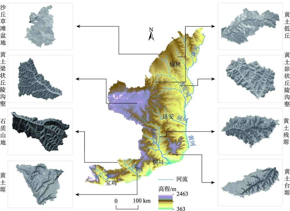
    Fig. 1. Elevation of the study area and distribution of sampled geomorphic types
    Result of small watershed division
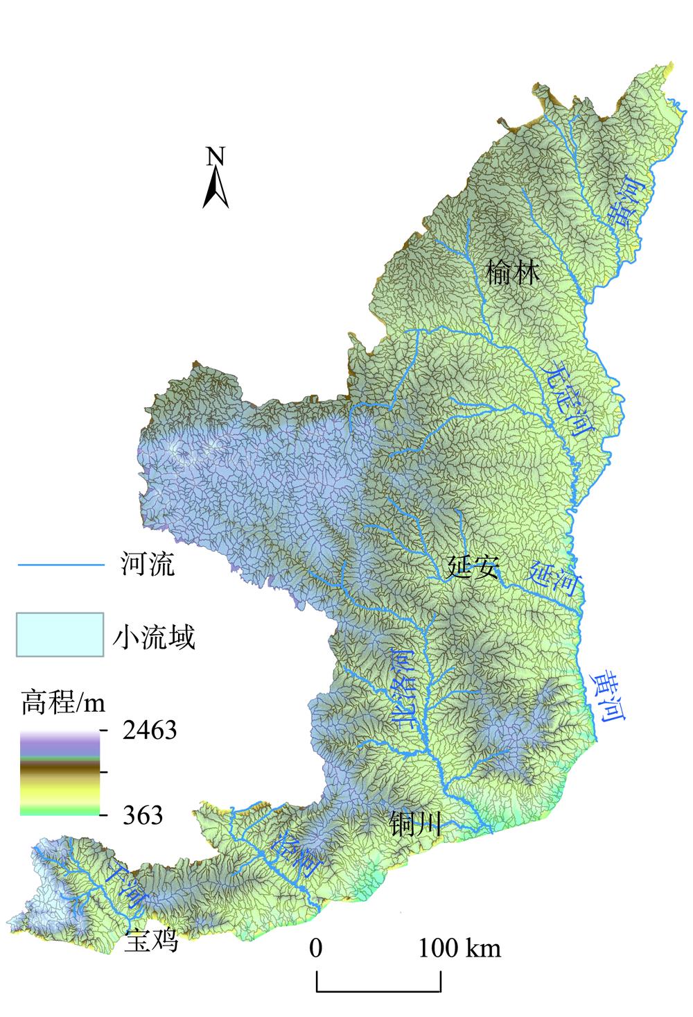
    Fig. 2. Result of small watershed division
    Principle of Random Forest[56]
    Fig. 3. Principle of Random Forest[56]
    Importance ranking of each feature of watershed in training area
    Fig. 4. Importance ranking of each feature of watershed in training area
    Relationship between prediction accuracy and features number
    Fig. 5. Relationship between prediction accuracy and features number
    Calibration results of the nTrees parameter
    Fig. 6. Calibration results of the nTrees parameter
    Classification result of watershed based on random forest
    Fig. 7. Classification result of watershed based on random forest
    Result of fusion processing of classified watershed
    Fig. 8. Result of fusion processing of classified watershed
    Spatial distribution of randomly sampled watersheds (used for accuracy verification)
    Fig. 9. Spatial distribution of randomly sampled watersheds (used for accuracy verification)
    类型小流域特征数量/个
    基本地形因子统计量平均高程、高程标准差、平均坡度、坡度标准差、平均起伏度、起伏度标准差、平均切割深度、切割深度标准差、平均平面曲率、平面曲率标准差、平均剖面曲率、剖面曲率标准差、平均坡向、坡向标准差14
    地形特征点线统计量山顶点密度、山顶点高程标准差、沟沿线密度、沟沿线平均高程、割裂度、沟谷线密度、沟谷线平均高程7
    小流域特征相对高程差、沟谷深度、面积高程积分、坡谱信息熵4
    纹理特征纹理对比度、纹理角二阶矩、纹理信息熵、纹理逆差矩4
    Table 1. Preliminary selection of basin features
    地貌类型样区小流域数量/个
    沙丘草滩盆地30
    黄土低丘30
    黄土峁状丘陵沟壑30
    黄土梁状丘陵沟壑30
    黄土残塬丘陵沟壑30
    石质山地30
    黄土塬16
    黄土台塬14
    汇总210
    Table 2. Number of sample areas per geomorphological type
    RF分类结果
    T1T2T2/T1T3T4T4/T3T5T6T7T8
    人工判读结果T113100000000
    T201000000000
    T2/T11200000000
    T301012000000
    T401001000000
    T4/T30003100000
    T500000013010
    T600001021300
    T70000001090
    T80000000005
    Table 3. Confusion Matrix between RF classification result and manual interpretation result
    地貌类型正确分类数量/个错误分类数量/个分类精度/%
    T113192.9
    T210566.7
    T312380.0
    T410283.3
    T513381.3
    T6130100.0
    T79190.0
    T850100.0
    汇总851585.0
    Table 4. Classification accuarcies of different landforms
    Zetao CAO, Zidong FANG, Jin YAO, Liyang XIONG. Loess Landform Classification based on Random Forest[J]. Journal of Geo-information Science, 2020, 22(3): 452
    Download Citation