• Journal of Geographical Sciences
  • Vol. 30, Issue 4, 569 (2020)
Gui JIN1, Xin SHI2, Dawei HE2、*, Baishu GUO2, Zhaohua LI2, and Xianbin SHI3
Author Affiliations
  • 1College of Urban and Environmental Sciences, Central China Normal University, Wuhan 430079, China
  • 2Faculty of Resources and Environmental Science, Hubei University, Wuhan 430062, China
  • 3Hubei Geological Survey Institute, Wuhan 430030, China
  • show less
    DOI: 10.1007/s11442-020-1743-6 Cite this Article
    Gui JIN, Xin SHI, Dawei HE, Baishu GUO, Zhaohua LI, Xianbin SHI. Designing a spatial pattern to rebalance the orientation of development and protection in Wuhan[J]. Journal of Geographical Sciences, 2020, 30(4): 569 Copy Citation Text show less
    Location of Wuhan within the Yangtze River Economic Belt (a), and administrative divisions of the city (b)
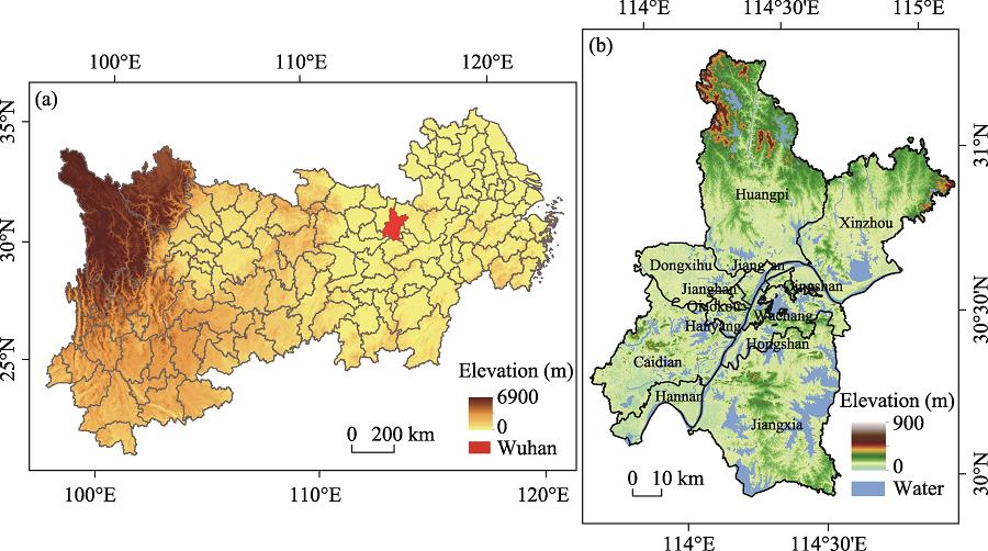
    Fig. 1. Location of Wuhan within the Yangtze River Economic Belt (a), and administrative divisions of the city (b)
    Schematic of circuit theory: resistance surface (a) and spatial pattern (b) (Spear, 2010)
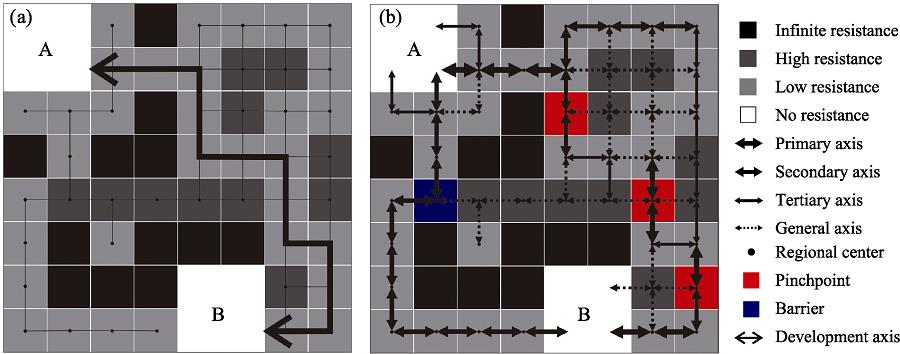
    Fig. 2. Schematic of circuit theory: resistance surface (a) and spatial pattern (b) (Spear, 2010)
    Spatial distribution of core areas (a) and development resistance (b)
    Fig. 3. Spatial distribution of core areas (a) and development resistance (b)
    Least-cost path (a) and current density (b) of spatial development
    Fig. 4. Least-cost path (a) and current density (b) of spatial development
    The patterns of spatial development and protection in Wuhan
    Fig. 5. The patterns of spatial development and protection in Wuhan
    TermsGeographical significance
    CurrentProbability of each element flowing through a geographic unit in the pattern of spatial protection and development
    ResistanceThe resistance to development of the spatial unit; the geographical unit with a tendency toward protection is assigned a high resistance value
    VoltageThe probability that the spatial element leaves a node and successfully reaches a specified node is also the probability that two nodes can be connected through the axis
    Effective resistanceResistance distance of different paths between nodes
    GroundEndpoint of the spatial development axis
    Table 1.

    Comparison of physical terms and their geographical significance in circuit theory

    Code of core areaCode of core area
    234567
    15.0617.716.7517.9517.3426.01
    221.31515.1115.3723.26
    316.2229.1527.7737.1
    44.875.0313.72
    513.2912.8
    619.25
    Table 2.

    Resistance distance between pairwise cores

    Gui JIN, Xin SHI, Dawei HE, Baishu GUO, Zhaohua LI, Xianbin SHI. Designing a spatial pattern to rebalance the orientation of development and protection in Wuhan[J]. Journal of Geographical Sciences, 2020, 30(4): 569
    Download Citation