• Acta Optica Sinica
  • Vol. 38, Issue 5, 0528003 (2018)
Yingying Li1、*, Hao Wu1, Xueli Chang1、2, and Yufeng Cheng1
Author Affiliations
  • 1 Beijing Institute of Remote Sensing Information, Beijing 100192, China
  • 1 School of Resource and Environment Sciences, Wuhan University, Wuhan, Hubei 410083, China
  • 1 State Key Laboratory of Information Engineering in Surveying, Mapping and Remote Sensing, Wuhan University, Wuhan, Hubei 430072, China
  • 2 Collaborative Innovation Center of Geospatial Technology, Wuhan, Hubei 430079, China
  • show less
    DOI: 10.3788/AOS201838.0528003 Cite this Article Set citation alerts
    Yingying Li, Hao Wu, Xueli Chang, Yufeng Cheng. Multi-View Stereo Positioning Error Analysis Based on Spaceborne Optics and SAR Images[J]. Acta Optica Sinica, 2018, 38(5): 0528003 Copy Citation Text show less
    RPC solution of SAR and its equivalent stereo intersection with CCD
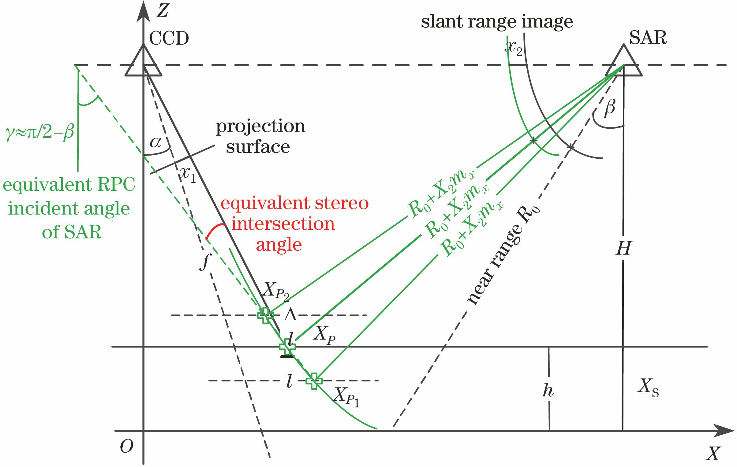
    Fig. 1. RPC solution of SAR and its equivalent stereo intersection with CCD
    Variations in (a)(b) elevation error and (c)(d) plane error with image source intersection angle
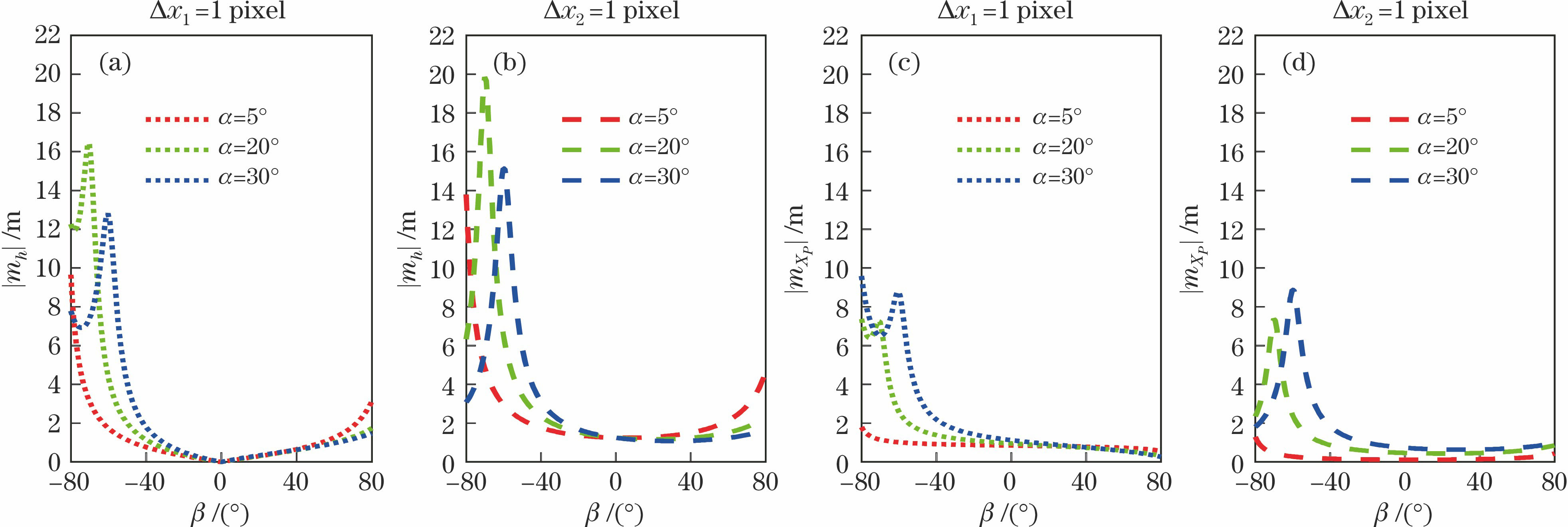
    Fig. 2. Variations in (a)(b) elevation error and (c)(d) plane error with image source intersection angle
    Variation in elevation error with (a) Δx1 and (b) Δx2
    Fig. 3. Variation in elevation error with (a) Δx1 and (b) Δx2
    (a) Schematic of elevation error caused by measurement error Δx1 of CCD;(b) schematic of elevation error caused by measurement error Δx2 of SAR
    Fig. 4. (a) Schematic of elevation error caused by measurement error Δx1 of CCD;(b) schematic of elevation error caused by measurement error Δx2 of SAR
    (a) Plane error and (b) elevation error of group A under four-point control condition
    Fig. 5. (a) Plane error and (b) elevation error of group A under four-point control condition
    Schematic of relative position of images in group B
    Fig. 6. Schematic of relative position of images in group B
    Equivalent RPC incident light perspectives for each image
    Fig. 7. Equivalent RPC incident light perspectives for each image
    GroupImageLoad typeAcquisition timeAscend or descend trackDirection of side viewSide view angle /(°)
    A1CCD2012-10Descend trackLeft6.75
    2CCD2013-03Descend trackLeft2.47
    3SAR2011-11Ascend trackRight36.41
    B4CCD2014-12Descend trackLeft6.07
    5CCD2015-04Descend trackLeft28.17
    6CCD2015-01Descend trackRight2.74
    7SAR2015-01Ascend trackRight37.57
    8SAR2015-01Descend trackRight35.97
    Table 1. Basic parameters of satellite images participating in tests
    Group No.Image compositionEquivalent maximum stereo intersection angle /(°)Error at check points /m
    X-directionY-directionPlaneElevation
    B1Homogenous and different side 4/67.161.5332.1792.66418.227
    B2Homogenous and same side 4/525.501.9622.4363.1283.311
    B3Homogenous and different side 5/632.601.7113.1663.5983.621
    B4Homogenous 4/5/632.601.5182.5642.9793.445
    B5Heterogenous and different side 5/820.805.2863.0206.0885.643
    B6Heterogenous and different side 4/846.301.8661.8722.6432.933
    B7Heterogenous and same side 6/853.401.6822.5003.0132.945
    B8Heterogenous 4/5/846.302.2072.2433.1462.569
    B9Heterogenous 4/5/6/853.401.5952.3582.8472.416
    Table 2. Plane error and elevation error for group B under three-point control condition
    Yingying Li, Hao Wu, Xueli Chang, Yufeng Cheng. Multi-View Stereo Positioning Error Analysis Based on Spaceborne Optics and SAR Images[J]. Acta Optica Sinica, 2018, 38(5): 0528003
    Download Citation