• Infrared and Laser Engineering
  • Vol. 49, Issue 11, 20200053 (2020)
Xuanzhe Zhang1、2、3, Yan Wang3, Jiahua Wang3, Zaihong Hou1、2, and Shaojun Du3
Author Affiliations
  • 1Hefei Institutes of Physical Science, Chinese Academy of Sciences, Hefei 230031, China
  • 2Science Island Branch, University of Science and Technology of China, Hefei 230026, China
  • 3College of Advanced Interdisciplinary Studies, National University of Defense Technology, Changsha 410073, China
  • show less
    DOI: 10.3788/IRLA20200053 Cite this Article
    Xuanzhe Zhang, Yan Wang, Jiahua Wang, Zaihong Hou, Shaojun Du. Image clarification and point cloud calculation under turbulence by light field camera[J]. Infrared and Laser Engineering, 2020, 49(11): 20200053 Copy Citation Text show less
    Phase space coordinates schematic diagram of the ray on transmission cross section
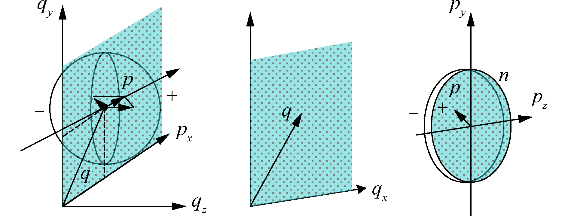
    Fig. 1. Phase space coordinates schematic diagram of the ray on transmission cross section
    Four density functions in optical phase space
    Fig. 2. Four density functions in optical phase space
    Light field camera 2.0 structure diagram
    Fig. 3. Light field camera 2.0 structure diagram
    Relationship of first three order aberration and corresponding deformation in phase space
    Fig. 4. Relationship of first three order aberration and corresponding deformation in phase space
    Calculation flow chart of full FOV phase map
    Fig. 5. Calculation flow chart of full FOV phase map
    3D reconstruction results of dynamic flame
    Fig. 6. 3D reconstruction results of dynamic flame
    Turbulence-degraded image clarifications experiment results
    Fig. 7. Turbulence-degraded image clarifications experiment results
    Outdoor turbulence-degraded image clarifications experiment results
    Fig. 8. Outdoor turbulence-degraded image clarifications experiment results
    Full FOV phase map (only unfocused item) of outdoor experiment
    Fig. 9. Full FOV phase map (only unfocused item) of outdoor experiment
    Theoretical depth resolution of target point cloud at 500 m
    Fig. 10. Theoretical depth resolution of target point cloud at 500 m
    MSSIMPNSR/dBTenengrad
    注:MSSIM(平均结构相似度指数)模拟人眼对图像结构相似性的认知,取值范围[0,1]。PNSR(峰值信噪比指数)是基于误差敏感的图像质量评价指标,PNSR越大则表明图像失真越小。Tenengrad梯度函数是基于图像梯度的评价函数,图像边缘越清晰,Tenengrad函数值越大。
    After clarification0.91650.2341.165
    Before clarification0.50147.1030.563 3
    Table 1.

    Analysis of turbulence-degraded imaging clarification quality

    湍流清晰化成像质量评价

    SMDTenengrad
    注:SMD(灰度方差指数)是图像全像素的灰度差分值之和,根据全聚焦图像中的高频分量最多的原理,将灰度变化作为聚焦评价的依据。根据表2,矫正后图像的SMD与Tenengrad值比未矫正图像的更高,这表明其具有更高的成像清晰度。
    After clarification24.631.089
    Before clarification20.970.870
    Table 2.

    Analysis of imaging quality

    成像质量分析

    Xuanzhe Zhang, Yan Wang, Jiahua Wang, Zaihong Hou, Shaojun Du. Image clarification and point cloud calculation under turbulence by light field camera[J]. Infrared and Laser Engineering, 2020, 49(11): 20200053
    Download Citation