• Chinese Journal of Lasers
  • Vol. 50, Issue 6, 0610002 (2023)
Zhenyang Hui, Na Li, Penggen Cheng*, Zhuoxuan Li, and Zhaochen Cai
Author Affiliations
  • Faculty of Geomatics, East China University of Technology, Nanchang 330013, Jiangxi, China
  • show less
    DOI: 10.3788/CJL220535 Cite this Article Set citation alerts
    Zhenyang Hui, Na Li, Penggen Cheng, Zhuoxuan Li, Zhaochen Cai. Single Tree Segmentation Method for Terrestrial LiDAR Point Cloud Based on Connectivity Marker Optimization[J]. Chinese Journal of Lasers, 2023, 50(6): 0610002 Copy Citation Text show less
    Flow diagram of proposed method
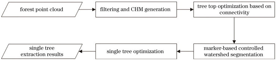
    Fig. 1. Flow diagram of proposed method
    Local extreme point detection
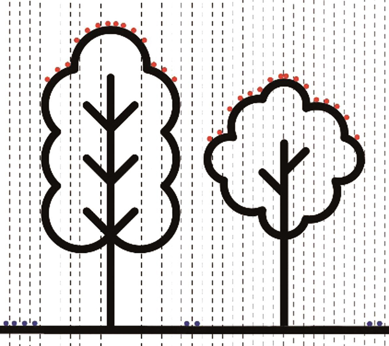
    Fig. 2. Local extreme point detection
    Search results of local extreme points. (a) Clustering result of connectivity growth; (b) three-dimensional clustering diagram of branches and trunks; (c) clustering status of branches and trunks; (d) result of extracting tree vertices
    Fig. 3. Search results of local extreme points. (a) Clustering result of connectivity growth; (b) three-dimensional clustering diagram of branches and trunks; (c) clustering status of branches and trunks; (d) result of extracting tree vertices
    Schematics of density contour. (a) Schematic of under-segmented two-dimensional density contours; (b) schematic of under-segmented three-dimensional density contours
    Fig. 4. Schematics of density contour. (a) Schematic of under-segmented two-dimensional density contours; (b) schematic of under-segmented three-dimensional density contours
    Schematics of under-segmentation. (a) Result of low vegetation segmentation; (b) result of double tree segmentation; (c) result of three wood tree segmentation
    Fig. 5. Schematics of under-segmentation. (a) Result of low vegetation segmentation; (b) result of double tree segmentation; (c) result of three wood tree segmentation
    TLS point cloud data. (a) Sample 1; (b) sample 2; (c) sample 3
    Fig. 6. TLS point cloud data. (a) Sample 1; (b) sample 2; (c) sample 3
    Single tree segmentation results in this study. (a) Sample 1; (b) sample 2; (c) sample 3
    Fig. 7. Single tree segmentation results in this study. (a) Sample 1; (b) sample 2; (c) sample 3
    Segmentation results by different single tree segmentation methods
    Fig. 8. Segmentation results by different single tree segmentation methods
    Single tree extraction result of mixed woodland. (a) 3D point cloud data of mixed woodland; (b) segmentation result of proposed method
    Fig. 9. Single tree extraction result of mixed woodland. (a) 3D point cloud data of mixed woodland; (b) segmentation result of proposed method
    SampleParameterMeanshift methodMarker-based watershed methodProposed method
    Sample 1Ccompleteness /%71.4368.5777.14
    Ccorrectness /%25.0043.6475.00
    Aaccuracy /%37.0453.3376.06
    Nref353535
    Nextr1005536
    Nmatch252427
    Sample 2Ccompleteness /%69.2373.0875.00
    Ccorrectness /%41.3844.1973.58
    Aaccuracy /%51.8055.0774.29
    Nref525252
    Nextr878653
    Nmatch363839
    Sample 3Ccompleteness /%38.7541.1245.00
    Ccorrectness /%25.4035.1058.06
    Aaccuracy /%30.6937.9350.70
    Nref808080
    Nextr1229462
    Nmatch313336
    Table 1. Results of three single tree segmentation methods
    Zhenyang Hui, Na Li, Penggen Cheng, Zhuoxuan Li, Zhaochen Cai. Single Tree Segmentation Method for Terrestrial LiDAR Point Cloud Based on Connectivity Marker Optimization[J]. Chinese Journal of Lasers, 2023, 50(6): 0610002
    Download Citation