• Infrared and Laser Engineering
  • Vol. 50, Issue 8, 20200396 (2021)
Junfeng Xie1, Ren Liu2、*, Zongwei Wang3, fan Mo1, and Xianhui Dou1
Author Affiliations
  • 1Land Satellite Remote Sensing Application Center, Ministry of Natural Resources, Beijing 100048, China
  • 2School of Earth Sciences and Engineering, Hohai University, Nanjing 211100, China
  • 3Jiangsu Province Surveying & Mapping Engineering Institute, Nanjing 210013, China
  • show less
    DOI: 10.3788/IRLA20200396 Cite this Article
    Junfeng Xie, Ren Liu, Zongwei Wang, fan Mo, Xianhui Dou. In-orbit geometric calibration and accuracy evaluation of GaoFen-7 spaceborne laser altimeter[J]. Infrared and Laser Engineering, 2021, 50(8): 20200396 Copy Citation Text show less
    Earth observation diagram of GF-7 spaceborne laser altimetry system
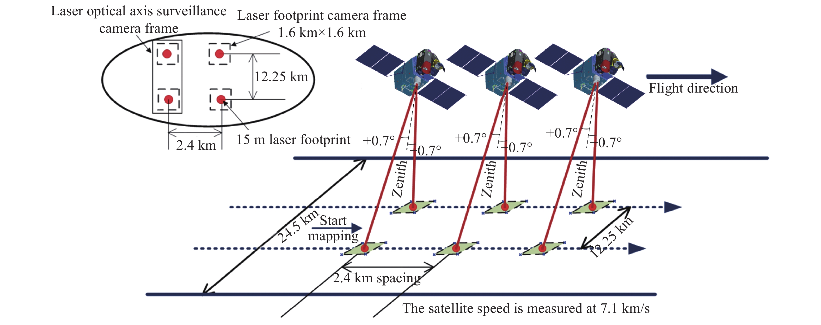
    Fig. 1. Earth observation diagram of GF-7 spaceborne laser altimetry system
    Geometric calibration diagram of spaceborne laser based on terrain matching
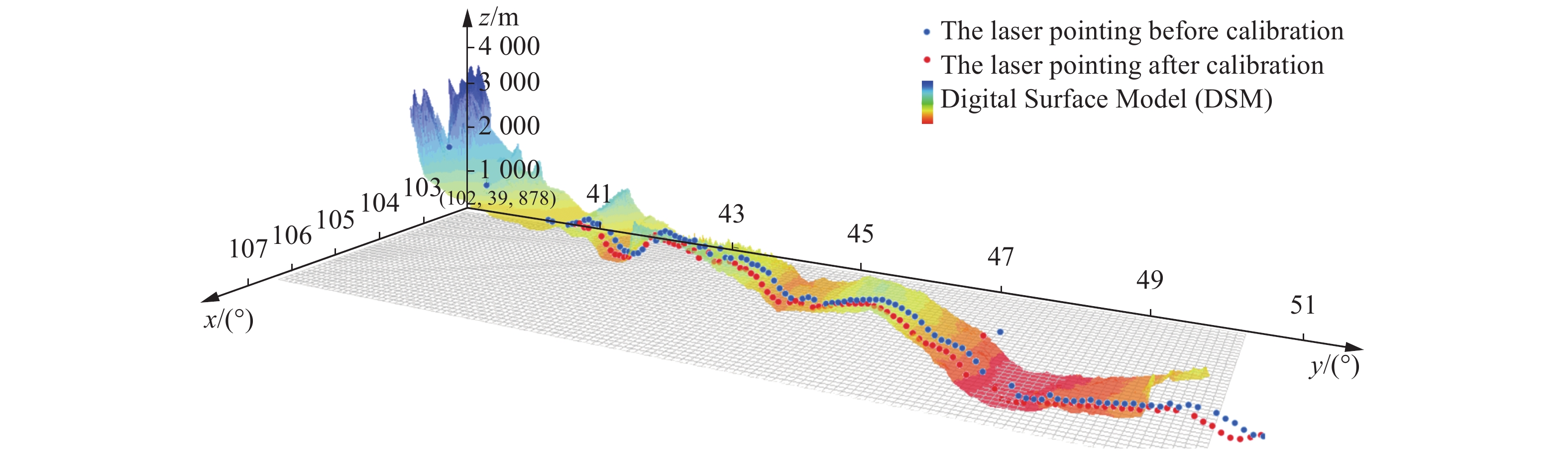
    Fig. 2. Geometric calibration diagram of spaceborne laser based on terrain matching
    Geometric calibration diagram of spaceborne laser based on single footprint image
    Fig. 3. Geometric calibration diagram of spaceborne laser based on single footprint image
    Geometric calibration diagram of spaceborne laser based on triggered ground detector. (a) Physical drawing of detectors triggered by GF-7; (b) Spot of GF-7 beam 1 after fitting; (c) Spot of GF-7 beam 2 after fitting
    Fig. 4. Geometric calibration diagram of spaceborne laser based on triggered ground detector. (a) Physical drawing of detectors triggered by GF-7; (b) Spot of GF-7 beam 1 after fitting; (c) Spot of GF-7 beam 2 after fitting
    Test flow chart
    Fig. 5. Test flow chart
    Calibration data in this paper
    Fig. 6. Calibration data in this paper
    Accuracy verification data of GF-7 spaceborne laser
    Fig. 7. Accuracy verification data of GF-7 spaceborne laser
    Precise attitude data of GF-7 satellite
    Fig. 8. Precise attitude data of GF-7 satellite
    Precise track data of GF-7 satellite
    Fig. 9. Precise track data of GF-7 satellite
    The 672th track beam 1 laser elevation precision under three kinds of calibration method
    Fig. 10. The 672th track beam 1 laser elevation precision under three kinds of calibration method
    The 672th track beam 2 laser elevation precision under three kinds of calibration method
    Fig. 11. The 672th track beam 2 laser elevation precision under three kinds of calibration method
    Laser point203600254.00204032175.67
    Pressure/Pa90082.3389454.00
    Precipitable water/mm7.430015.1200
    Dry delay/m2.0342.0200
    Wet delay/m0.00060.0012
    Total delay/m2.03402.0210
    Table 1. Atmospheric correction of GF-7 calibration laser point
    Laser point203600254.00204032175.67
    Solid tide/m0.01330.2257
    Pole tide/m−0.0057−0.0058
    Sea tide/m0.00000.0000
    Wet delay/m0.00100.0018
    Total delay/m0.00860.2217
    Table 2. Tidal correction of GF-7 calibration laser point
    Calibration methodBeam 1Beam 2
    ${\rm d}\alpha$/(°) ${\rm d}\beta$/(°) ${\rm d}\alpha$/(°) ${\rm d}\beta$/(°)
    TMC0.0300−0.04000.1080−0.0460
    SLFIC0.0310−0.03680.1081−0.0441
    GDC0.0304−0.03780.1073−0.0445
    Table 3. Three kinds of calibration methods to calibrate GF-7 laser pointing deviation
    Calibration method Beam 1Beam 2
    Mean value/mRMSE/mMean value/mRMSE/m
    TMC−0.7640.363−0.8660.722
    SLFIC−0.6730.196−0.7020.605
    GDC0.0340.177−0.0220.157
    Table 4. Accuracy of three calibration methods
    Junfeng Xie, Ren Liu, Zongwei Wang, fan Mo, Xianhui Dou. In-orbit geometric calibration and accuracy evaluation of GaoFen-7 spaceborne laser altimeter[J]. Infrared and Laser Engineering, 2021, 50(8): 20200396
    Download Citation