• Journal of Geographical Sciences
  • Vol. 30, Issue 4, 642 (2020)
Fang ZHAO1、2, Junjie LIU1, Wenbo ZHU1, Baiping ZHANG3、*, and Lianqi ZHU1
Author Affiliations
  • 1College of Environment and Planning, Henan University, Kaifeng 475004, Henan, China
  • 2Key Laboratory of Geospatial Technology for the Middle and Lower Yellow River Regions, Henan University, Kaifeng 475004, Henan, China
  • 3State Key Laboratory of Resource and Environment Information System, Institute of Geographic Sciences and Natural Resources Research, CAS, Beijing 100101, China
  • show less
    DOI: 10.1007/s11442-020-1747-2 Cite this Article
    Fang ZHAO, Junjie LIU, Wenbo ZHU, Baiping ZHANG, Lianqi ZHU. Spatial variation of altitudinal belts as dividing index between warm temperate and subtropical zones in the Qinling-Daba Mountains[J]. Journal of Geographical Sciences, 2020, 30(4): 642 Copy Citation Text show less
    Data sites of altitudinal belts in the Qinling-Daba Mountains
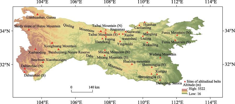
    Fig. 1. Data sites of altitudinal belts in the Qinling-Daba Mountains
    North-south variation of altitudinal belt spectra in the Qinling-Daba Mountains
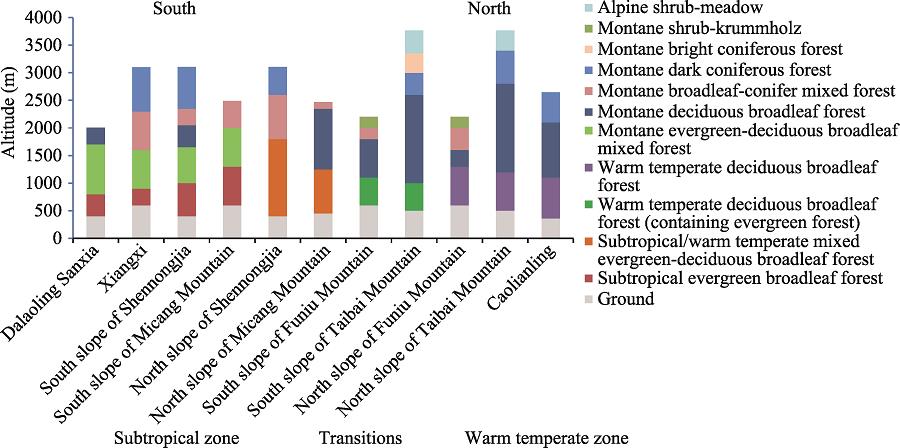
    Fig. 2. North-south variation of altitudinal belt spectra in the Qinling-Daba Mountains
    Latitudinal distribution of the upper limit of the evergreen-deciduous broadleaf mixed forest belt in the Qinling-Daba Mountains
    Fig. 3. Latitudinal distribution of the upper limit of the evergreen-deciduous broadleaf mixed forest belt in the Qinling-Daba Mountains
    Latitudinal distribution of the upper limits of the montane deciduous broadleaf forest belt (a) and broadleaf-conifer mixed forest belt (b) in the Qinling-Daba Mountains
    Fig. 4. Latitudinal distribution of the upper limits of the montane deciduous broadleaf forest belt (a) and broadleaf-conifer mixed forest belt (b) in the Qinling-Daba Mountains
    Mountain altitudinal belts from east to west on the north slope of the Qinling Mountains
    Fig. 5. Mountain altitudinal belts from east to west on the north slope of the Qinling Mountains
    Mountain altitudinal belts from east to west on the south slope of the Qinling Mountains
    Fig. 6. Mountain altitudinal belts from east to west on the south slope of the Qinling Mountains
    Mountain altitudinal belts from east to west in the Daba Mountains
    Fig. 7. Mountain altitudinal belts from east to west in the Daba Mountains
    Longitudinal distribution of the upper limit of the evergreen-deciduous broadleaf mixed forest belt in the Qinling-Daba Mountains
    Fig. 8. Longitudinal distribution of the upper limit of the evergreen-deciduous broadleaf mixed forest belt in the Qinling-Daba Mountains
    Longitudinal distribution of the upper limit of the montane deciduous broadleaf forest belt in the Qinling (a) and Daba (b) Mountains
    Fig. 9. Longitudinal distribution of the upper limit of the montane deciduous broadleaf forest belt in the Qinling (a) and Daba (b) Mountains
    Longitudinal distribution of the upper limit of the broadleaf-conifer mixed forest belt in the Qinling (a) and Daba (b) Mountains
    Fig. 10. Longitudinal distribution of the upper limit of the broadleaf-conifer mixed forest belt in the Qinling (a) and Daba (b) Mountains
    SiteLocationlatitude (°)Longitude (°)Altitude (m)WI (℃·month)AMT (℃)MTWM (℃)MTCM (℃)AP(mm)
    SongxianNorth slope of Qinling34.1112.1326128.21526.60.8689
    Luoning34.4111.1328121.714.425.90.6569
    Liquan34108.5543113.313.425.70.9541
    Qinling Mountains
    ShannanSouth slope of QinlingNorth slope of Daba33.5110.9523118.814.425.11.6864
    Hanzhong33.1107510123.51525.62.8838
    Shiquan33108.3485123.415.125.53890
    Hanyin32.9108.1413127.215.4263.3904
    Daba Mountains
    GuanyuanSouth slope of Daba32.4105.8514140.616.726.25.4929
    Wangcang32.2106.3486141.316.826.35.41158
    Nanzhang31.8111.1151135.916.127.32.6912
    Wuxi31.4109.6338156.618.127.86.71091
    Xingshan31.4110.7337148.517.427.35.5977
    Table 1.

    Climatic variables from weather stations in the piedmont of the Qinling-Daba Mountains (WI: warmth index; AMT: annual biotemperature; MTWM: mean temperature for the warmest month; MTCM: mean temperature for the coldest month; AP: annual precipitation; data from CIMISS http://data.cma.cn/)

    Fang ZHAO, Junjie LIU, Wenbo ZHU, Baiping ZHANG, Lianqi ZHU. Spatial variation of altitudinal belts as dividing index between warm temperate and subtropical zones in the Qinling-Daba Mountains[J]. Journal of Geographical Sciences, 2020, 30(4): 642
    Download Citation