Objective High-temporal and high-resolution thermal infrared remote sensing images are important resources for researches of fine characterization of human traces, inversion of Earth surface features, resource exploration, and marine ecological monitoring. At present, different thermal infrared payloads (TIRPs) have been carried by the Earth remote sensing satellites at home and abroad. According to magnitudes of spatial resolution and imaging width, TIRPs can be divided into three kinds: 1) large width and low resolution, mainly including TIRPs with a width greater than 1000 km and resolution lower than 1 km, such as the moderate-resolution imaging spectroradiometer (MODIS) and the infrared atmospheric sounder (IRAS) carried on Terra and FY-3D satellites, respectively; 2) medium width and medium resolution, including thermal infrared cameras with a width of 100-1000 km and a resolution of 100-1000 m, such as TM/ETM+/TIRS of Landsat 5/7/8; 3) narrow width and high resolution, generally referring to the width less than 100 km and the resolution better than 100 m, such as the visual and infrared multispectral imager (VIMI) aboard GF-5 and the long-wave infrared camera of VRSS-2.
The special project of "Big Earth Data Science Engineering Project" proposes to make fine depictions of human activity traces and coastal ecology based on remote sensing data, and to realize real-time quantitative observation of urban heat island, human economic activities and polar environmental changes mainly by thermal infrared and low-light-level cameras, which puts forward higher requirements for the spatial and temporal resolutions of corresponding payloads. Generally, there are two types of data acquisition methods for remote sensing cameras with linear detectors including the push-broom with a long linear-array and the whisk-broom with a short linear-array. However, affected by engineering boundary constraint conditions such as structure size, weight, and power consumption of the satellite, the imaging method of push-broom with a long linear-array is difficult to meet the requirements of short-term, wide-range and high-resolution. Accordingly, the whisk-broom imaging with a long linear-array is an effective method for solving this contradiction.
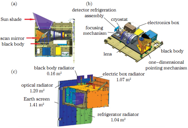
Methods In view of the above requirements, this research proposes a whisk-broom imaging method based on a long multiple-modules-stitched linear-array thermal infrared sensor with three spectral segments, and realizes the wide-range and high-resolution ground imaging with a width of 300 km and a resolution of 30 m (sub-satellite point) at an orbital altitude of 505 km. On the one hand, in order to achieve a large range of coverage along the orbit, the thermal infrared imager (TIRI) detector is composed of four 512×4×3 long-wave time delay integration focal plane modules which are cross stitched together (
Results and Discussions Based on the analysis above, the innovative results of this research mainly include two aspects: 1) wide-range and high-resolution imaging technology; the TIRI of CASEarth small satellite adopts a multi-module splicing long-linear detector (
Conclusions Aiming at the technological frontier of wide-range and high-resolution imaging, this research, guided by the project of CASEarth TIRI, conducts the researches including the designs of all-optical path cryogenic optical system and multi-module splicing long-linear detectors, the whisk-broom imaging with a long-linear detector array, and the radiation calibration methods (