
Yonghui YAO, Dongzhu SUONAN, Junyao ZHANG. Compilation of 1:50,000 vegetation type map with remote sensing images based on mountain altitudinal belts of Taibai Mountain in the North-South transitional zone of China[J]. Journal of Geographical Sciences, 2020, 30(2): 267
- Journal of Geographical Sciences
- Vol. 30, Issue 2, 267 (2020)
Abstract
Keywords
1 Introduction
Before 1957, vegetation mapping in China was mainly focused on small-scale vegetation sketch maps and vegetation regionalization maps. In this period, the study of vegetation mapping was in the early stage of dispersion and spontaneity (
The above vegetation mapping efforts were made based on the traditional ground surveys which took a lot of manpower and were time-consuming. On the one hand, limited by computer technology and remote sensing technology at that time, the conditions for using remote sensing data to compile vegetation maps were still immature; on the other hand, the compilation of small-scale vegetation maps through ground survey could meet the social needs at that time. In the 21st century, with the development of remote sensing technology, it has become very common to use remote sensing data for the studies of land use and land cover change, vegetation change, vegetation phenology monitoring and forest resource surveys in a large-scale.
With the development of remote sensing extraction technologies, the condition which using multi-source remote sensing big data to develop medium- and large-scale vegetation mapping has become matured. In Scientific and Technological Basic Resources Survey Project Comprehensive Scientific Investigation of the North-South Transitional Zone of China (2017FY100900), a series of comprehensive investigations on vegetation, soil, climate, hydrology and other resources in the region are carried out. One of the important tasks in this project is to compile the 1:250,000 vegetation type map of the Transitional Zone and the 1:50,000 vegetation type maps in four typical mountains using remote sensing data combined with field investigations. In addition, the North-South transitional zone has a particularly prominent position and significance in geo-ecological pattern in China. Under the background of global change, the compilation of medium and large-scale vegetation type maps in the transitional zone is very important for the in-depth study of the spatial-temporal variation rules of vegetation in the transitional zone (
2 Vegetation outline of Taibai Mountain in Qinling Mountains
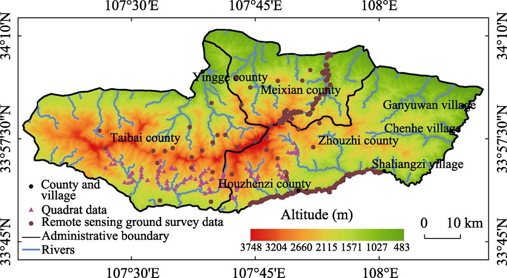
Taibai Mountain is located in the central part of the Qinling Mountains in Shaanxi province (107°41°23-107°51°40E, 33°49°31-34°08°11N). It is the southern boundary of the warm temperate zone and the northern boundary of the subtropical zone in China (
![]()
Figure 1.
Due to the difference in climate, the mountain altitudinal belts on the north and south slopes of Taibai Mountain are different in the characteristics of the base belt and the distribution height of each altitudinal belt (
![]()
Figure 2.
3 Data and methods
3.1 Datasets
High-resolution remote sensing data, Digital Surface Model (DSM) data, remote sensing ground survey data and quadrat data are used to compile the 1:50,000 vegetation type map of Taibai Mountain in this paper.
(1) High-resolution remote sensing data
Remote sensing data used for vegetation classification in this paper include 4 GF-2 images, 13 GF-1 images and 21 ZY-3 images (
| Sensor | Time | Resolution | Sensor | Time | Resolution |
|---|---|---|---|---|---|
| GF2 | August 3, 2017 | 0.8 m | ZY3 | September 28, 2017 | 2 m |
| September 7, 2017 | 0.8 m | August 5, 2017 | 2 m | ||
| September 7, 2017 | 0.8 m | August 31, 2016 | 2 m | ||
| August 3, 2017 | 0.8 m | February 3, 2018 | 2 m | ||
| GF1 | August 28, 2016 | 2 m | February 8, 2018 | 2 m | |
| November 30, 2016 | 2 m | September 28, 2017 | 2 m | ||
| October 28, 2017 | 2 m | August 5, 2017 | 2 m | ||
| February 12, 2017 | 2 m | August 31, 2016 | 2 m | ||
| August 28, 2016 | 2 m | February 3, 2018 | 2 m | ||
| November 30, 2016 | 2 m | February 8, 2018 | 2 m | ||
| October 28, 2017 | 2 m | July 14, 2017 | 2 m | ||
| February 12, 2017 | 2 m | September 22, 2016 | 2 m | ||
| August 8, 2017 | 16 m | September 22, 2016 | 2 m | ||
| January 20, 2015 | 16 m | November 10, 2016 | 2 m | ||
| October 1, 2015 | 16 m | November 4, 2017 | 2 m | ||
| July 1, 2017 | 16 m | January 13, 2017 | 2 m | ||
| February 12, 2017 | 16 m | July 14, 2017 | 2 m | ||
| ZY3 | November 4, 2017 | 2 m | September 22, 2016 | 2 m | |
| January 13, 2017 | 2 m | November 10, 2016 | 2 m |
Table 1.
Remote sensing images of Taibai Mountain
(2) Ground survey data
Ground survey data used in this paper are remote sensing ground survey data and quadrat data. From June 8 to June 15, 2018, our research team carried out a field survey in Taibai Mountain and acquired 286 remote sensing ground survey data by GPS sampling and the Ovey Interactive Map. These ground survey data include geographical location, vegetation type groups, vegetation types, vegetation formations/sub-formations and other information of the sample points. Additionally, a total of 181 quadrat data were collected from the comprehensive investigation project of National Nature Reserve in Taibai Mountain, Shaanxi province.
(3) Digital surface model (DSM) data
The 1:10,000 DSM data of Taibai Mountain (resolution 10 m) was generated from ZY-3 satellite images. DSM data in this paper is mainly used to extract the slope, slope direction, altitude and surface coverage data of fine scale, and it is also used to construct terrain constraint factors.
(4) Vegetation map data of Taibai Mountain
The vegetation map data include the 1:1,000,000 Vegetation Map of China in 2000 and the Vegetation Distribution Map of Taibai Mountain compiled by the “Comprehensive Investigation Project of Taibai Mountain National Nature Reserve, Shaanxi Province” in 2006. These earlier vegetation maps can provide qualitative references and comparative studies for the classification of vegetation types.
3.2 Methods
(1) Classification system of 1:50,000 vegetation type map of Taibai Mountain in Qinling Mountains
The classification system of 1:50,000 vegetation type map of Taibai Mountain in Qinling Mountains still adopts the classification system of 1:1,000,000 Vegetation Map of China, but it refines the formation group, formation and sub-formations according to the actual situation. The classification system of the 1:1,000,000 Vegetation Map of China uses six classification levels, namely vegetation type group, vegetation type, vegetation sub-type, formation group, formations and sub-formation. The legend system is divided into four levels: Level 1 includes 11 vegetation type groups (coniferous forest, coniferous and broad-leaved mixed forest, broad-leaved forest, shrub, desert, grassland, herbosa, meadow, swamp, alpine vegetation and cultivated vegetation); Level 2 includes 53 vegetation types and 2 vegetation sub-types, a total of 55 types; Level 3 includes 11 formation groups, 571 formations and 4 sub-formations, a total of 586 types, it is the basic units of the map; Level 4 includes 29 formations, 244 sub-formations, a total of 273 types, it is the lowest-level mapping units.
In the 1:1,000,000 Vegetation Map of China, the vegetation of Taibai Mountain was divided into 6 vegetation type groups (coniferous forest, broad-leaved forest, shrub, herbosa, meadow and cultivated vegetation), 11 vegetation types and sub-types, and 24 vegetation formations and sub-formations. In this paper, vegetation of Taibai Mountain was also divided into six vegetation type groups (coniferous forest, coniferous and broad-leaved mixed forest, broad-leaved forest, shrub, meadow and cultivated vegetation), but 12 vegetation types and sub-types, and 52 vegetation formation groups, formations and sub-formations (
| Vegetation type groups | Vegetation types, sub-types | Vegetation formation groups, formations, sub-formation |
|---|---|---|
| Meadows | Kobresia, forbs alpine meadows | |
| Temperate grasses, forbs meadows | ||
| Shrubs | Subalpine deciduous broad-leaved shrubs | |
| Subalpine evergreen leather-leaved shrubs | ||
| Coniferous forests | Temperate coniferous forests | |
| Subtropical and tropical montane coniferous forests | ||
| Subtropical coniferous forests | ||
| Mixed forests | Temperate coniferous and deciduous broad-leaved mixed forests | |
| Subtropical montane coniferous and deciduous broad-leaved mixed forests | ||
| Broadleaf forests | Temperate deciduous broad-leaved forests | |
| Vegetation type groups | Vegetation types, sub-types | Vegetation formation groups, formations, sub-formation |
| Cultivated plants | Dry farming of three matures in two years or double cropping in one year | |
| Deciduous orchard |
Table 2.
Vegetation classification system of Taibai Mountain
(2) Remote sensing interpretation method for vegetation types in Taibai Mountain
Remote sensing interpretation of vegetation types in Taibai Mountain was carried out according to the following process: firstly, based on the 1:10,000 DSM data and the distribution heights of mountain altitudinal belts (MABs) of Taibai Mountain, three types of terrain factors of the main ridge line, the slope direction and the elevations of MABs in the study area were extracted, and the terrain constraint factors with MABs information were generated by the above three types of terrain factors (
![]()
Figure 3.
With the assistance of terrain constraint factors, the vegetation type groups were extracted by visual interpretation according to the spectral features and texture features of high-resolution remote sensing images of 0.8 m and 2 m in Taibai Mountain (
![]()
Figure 4.
Based on the classification of vegetation type groups, vegetation formation groups, formations and sub-formations in Taibai Mountain were further divided. Pinus armandii, Abies fargesii, Larix chinensis are main vegetation formations of the coniferous vegetation type groups in Taibai Mountain, and they have distinct different distribution heights and ranges according to the terrain constraint factors and have different spectral and texture characteristics in the autumn and winter images. Particularly, Abies fargesii forest has very special spectral characteristics on pseudo-color image, thus its distribution range can be accurately extracted (
Finally, the spatial distribution characteristics of other vegetation formations were extracted and determined according to remote sensing ground survey data and quadrat surveys. On the basis of the classification of the above vegetation type groups and main vegetation formations, the multi-spectral remote sensing images of 2 m and 16 m in different seasons were used to analyze the spectral characteristics, NDVI and other characteristics of each vegetation formations with seasons. All vegetation formations were extracted by visual interpretation.
4 Results and analysis
(1) Classification results of vegetation type groups
The classification results of vegetation type groups are shown in
![]()
Figure 5.
(2) Classification results of vegetation formation groups, formations and sub-formations
In this experiment, there are 52 formation groups, formations and sub-formations in Taibai Mountain (
(3) Classification results of vegetation types and sub-types
Among 12 vegetation types and sub-types (
5 Conclusions and discussion
5.1 Conclusions
(1) The above experimental studies show that the information of mountain altitudinal belts (MABs) and vegetation geographical distribution could effectively support remote sensing classification and mapping of mountain vegetation. Firstly, with the assistant of terrain constraint factors with MABs information, vegetation type groups of Taibai Mountain can be extracted accurately from the multi-temporal remote sensing images. Secondly, based on the classification of six vegetation type groups, seven main vegetation formations, such as Pinus armandii forest, Abies fargesii forest, Larix chinensis forest and Betula albo- sinensis forest, can be distinguished and extracted according to terrain constraint factors and spectral characteristics of remote sensing image. Thirdly, other vegetation formations can be further determined according to the MABs, the relationship between vegetation formations, ground survey data and previous vegetation maps. Finally, vegetation types and sub-types are assigned according to the regional geographical characteristics, climatic conditions of the vegetation formations and the characteristics of the vegetation type groups.
(2) The process of complication of 1:50,000 vegetation type map based on remote sensing images is: interpretation of vegetation type-group→interpretation of vegetation formation groups, formations and subformations→interpretation and classification of vegetation types & subtypes, which is a combination method of top-down method and bottom-up method, not the top-down or the bottom-up classification according to the level of mapping units. In the classification system of vegetation type map, the vegetation type group is the highest classification unit, which is mainly divided according to the morphological characteristics of the constructive species communities, but also contains certain ecological content. Vegetation type and sub-type are higher classification unit between vegetation type group and vegetation formation group, formation and sub-formation. Vegetation type is composed of the constructive species with the same or similar life type and the plant communities with consistent ecological relationship and hydrothermal conditions. For zonal vegetation, vegetation type refers to the product of a certain climatic zone, and for intrazonal vegetation, it refers to the special habitat conditions of the communities. Vegetation sub-type is an auxiliary unit of vegetation type and reflects the difference of climate subzone, or the differences in vegetation lamellar structure caused by the differences of certain landform and matrix conditions. Therefore, the classification of vegetation types and sub-types is mainly based on the environmental conditions of the plant communities. Vegetation formation group, formation and sub-formation has the same or similar constructive species or co-constructed species and it is the basic mapping units of vegetation type maps. Thus, in the vegetation classification based on remote sensing imagines, for this three-level vegetation classification mapping units, only two of them (vegetation type group, and vegetation formation group, formation and sub-formation) can be interpreted according to image features such as texture, structure and spectral features combined with the auxiliary information such as MABs. While, the vegetation type and sub-type cannot be directly interpreted by image features, it needs to be classified according to types of vegetation type groups and the climatic conditions of vegetation formation groups, formations and sub-formations. Therefore, the basic remote sensing interpretation and mapping process for typical mountains is to extract vegetation type groups first, then extract vegetation formation groups, formations and sub-formations within the vegetation type groups, and finally assign the vegetation types and sub-types according to climate condition of the constructed species.
5.2 Discussion
(1) Some vegetation formations are still difficult to distinguish from others in this experiment. First of all, it is difficult to distinguish Quercus variabilis forest from Quercus aliena var. acuteserrata forest on the image feature, although the Quercus aliena var. acuteserrata forest is distributed above the Quercus variabilis forest. If the ground survey data are limited, it would be difficult to find out the precise distribution boundary between them only based on MABs. Secondly, it is also difficult to distinguish Quercus liaotungensis forest from Quercus aliena var. acuteserrata fortest in the north slope according to image characteristics, and a lot of ground survey data are needed to extract Quercus liaotungensis forest correctly. Finally, there are also some uncertainties for the classification of coniferous & broad-leaved mixed forests.
(2) The experimental study in this paper was still carried out by visual interpretation and auxiliary supervised classification. In the following research, we will study and establish a multi-source vegetation classification knowledge database that integrates various geoscience information (MABs information, terrain constraint factors, etc.), vegetation geography and previous vegetation classification information. According to knowledge transfer method, a set of vegetation remote sensing classification methods based on prior knowledge will be constructed (
References
[1] B Q Chen, X P Li, X M Xiao et al. Mapping tropical forests and deciduous rubber plantations in Hainan Island, China by integrating PALSAR 25-m and multi-temporal Landsat images. International Journal of Applied Earth Observation and Geoinformation, 50, 117-130(2016).
[2] . Atlas of 1:1000000 Chinese Vegetation(2000).
[3] . Vegetation and Its Geographical Patterns in China: Instructions for Vegetation Maps of the People’s Republic of China(2007).
[4] B Demir, F Bovolo, L Bruzzone et al. Updating land-cover maps by classification of image time series: A novel change-detection-driven transfer learning approach. IEEE Transactions on Geoscience and Remote Sensing, 51, 300-312(2013).
[5] Z Fang, S Z Gao. Vegetation altitudinal belts on the north and south slopes of Taibai Mountain in Qinling Mountains. Series of Plant Ecology and Geobotany, 162-163(1963).
[6] X Y Hou, R Z Ma. Vegetation-Soil Zoning Map of China(1956).
[7] X Y Hou, S Z Sun, J W Zhang et al. Vegetation Map of the People’s Republic of China (1:4000000)(1979).
[8] B Hu, H B Ju, Hua Liu et al. Combining multiple classifiers based on evidence theory for large scale vegetation types classification by remote sensing images. Forestry Research, 30, 194-199(2017).
[9] M M Jia, C Y Ren, D W Liu et al. Object-oriented forest classification based on combination of HJ-1 CCD and MODIS NDVI data. Acta Ecologica Sinica, 34, 7167-7174(2014).
[10] G B Lei, A N Li, J B Tan et al. Forest types mapping in mountainous area using multi-source and multi-temporal satellite images and decision tree models. Remote Sensing Technology and Application, 31, 31-41(2016).
[11] H N Li. Study on plant species diversity and vertical distribution patterns on the north slope of Taibai Mountain. Xi’an: Shaanxi Normal University(2007).
[12] Z Li, X M Yang, F Meng et al. LULC classification based on random forest with the aid of phonological feature. Remote Sensing Information, 28, 48-55(2013).
[13] J Y Liu. China Resources and Environment Remote Sensing Macro Survey and Dynamic Research(1996).
[14] J Y Liu, M L Liu, D F Zhuang et al. Study on spatial pattern of land-use change in China during 1995-2000. Science in China Series D: Earth Sciences, 46, 373-384(2003).
[15] J Y Liu, Z X Zhang, D F Zhuang et al. A study on the spatial-temporal dynamic changes of land-use and driving forces analyses of China in the 1990s. Geographical Research, 22, 1-12(2003).
[16] J Y Liu, Z X Zhang, X L Xu et al. Spatial patterns and driving forces of land use change in China during the early 21st century. Journal of Geographical Sciences, 20, 483-494(2010).
[17] X F Liu, Y Z Pan, X F Zhu et al. Spatiotemporal variation of vegetation coverage in Qinling-Daba Mountains in relation to environmental factors. Acta Geographica Sinica, 70, 705-716(2015).
[18] J C Luo, G J Wu, J L Li et al. Spatial-spectral Recognition of Remote Sensing(2017).
[19] A Marsetic, K Ostir, M K Fras. Automatic orthorectification of high-resolution optical satellite images using vector roads. IEEE Transactions on Geoscience and Remote Sensing, 53, 6035-6047(2015).
[20] A A Nielsen. The regularized iteratively reweighted MAD method for change detection in multi-and hyperspectral data. IEEE Transaction on Image Processing, 16, 463-478(2007).
[21] C S Qian. Draft of Vegetation Regionalization in China(1956).
[22] T J Wu, J C Luo, L G Xia et al. An automatic sample collection method for object-oriented classification of remotely sensed imageries based on transfer learning. Acta Geodaetica et Cartographica Sinica, 43, 908-916(2014).
[23] L G Xia. Research on automatic classification of remote sensing images coupled with “graph-spectrum” characteristics. Hangzhou: Zhejiang University of Technology(2011).
[24] M Yue. Vegetation altitudinal belts of Qinling Mountains. Forests and Human Beings, 2, 76-81(2015).
[25] J J Zhang, W B Zhu, F Zhao et al. Spatial variations of terrain and their impacts on landscape patterns in the transition zone from mountains to plains: A case study of Qihe River Basin in the Taihang Mountains. Science China Earth Sciences, 48, 476-486(2018).
[26] X D Zhang, W B Zhu, J J Zhang et al. Phenology of forest Qihe River Basin in the Taihang Mountains. Science China Earth Sciences, 48, 476-486(2018).


Set citation alerts for the article
Please enter your email address

© Copyright 2018-2021 | Chinese Laser Press. All Rights Reserved 沪ICP备15018463号-20