
Qingqing LIU, Hu YU. Functional Zoning Mode and Management Measures of Qianjiangyuan National Park based on Ecological Sensitivity Evaluation[J]. Journal of Resources and Ecology, 2020, 11(6): 617
- Journal of Resources and Ecology
- Vol. 11, Issue 6, 617 (2020)
Abstract
1 Introduction
Zoning is an effective way to achieve regional planning and construction as well as standardized management. The designation of national parks is a conservation technique employed worldwide, and building national parks is an indispensable part of China’s 13th five-year ecological civilization construction plan. In order to guarantee the sustainable development of national parks, managers usually introduce zoning according to the regional characteristics of the natural ecological system. This approach can control the use of natural resources and land utilization type, alleviate any conflict between different interest groups, and protect the integrity and biodiversity of the natural ecological systems. It thereby provides an institutional guarantee of conservation and recreational use of the parks (
Functional zoning controls are key measures in the governance of national parks. National park managers use functional zoning for land-use control and it is the main means of implementing part of the national park functions. Other studies have focused on the functional zoning management model and land ownership adjustments of parks in the USA, Canada, Japan, and other countries (
This paper analyzes the functional zoning method for Qianjiangyuan National Park (QNP), based on the ecological sensitivity evaluation, and then proposes a functional zoning method that conforms to the actual situation of regional development, which would be beneficial to the management and construction of China’s national parks.
2 Methods
2.1 Study area
The QNP is located in the Baiji Mountains in the northeast of Kaihua County, Quzhou City, Zhejiang Province. It is adjacent to the Wuyuan County of Jiangxi Province and the Xiuning County of Anhui Province. The QNP contains two national natural protection areas, namely Gutian Mountain National Nature Reserve (81.07 km2) and Qianjiangyuan National Forest Park (45 km2), as well as an ecological corridor connecting them (mostly comprising ecological public welfare forests) with a total area of 252 km2. The QNP’s objectives are to protect the important representative habitats of the area. These include typical, primitive, large, low-altitude, subtropical evergreen broad-leaved forests, and their living creatures. The ecosystem and landscape are rare in China and the world. The QNP has an obvious hypsographic feature, with an average elevation of about 600-700 m. The highest point is Green Peak (1236 m) in Gutian Mountain. Its water system includes Qianjiangyuan river system and Suzhuang river system. The QNP’s forest coverage rate is 81.70%, mainly concentrating on Qianjiangyuan National Forest Park and Gutian Mountain National Nature Reserve, and the two large areas of forest vegetation are above an altitude of 1000 m, where a lot of wild animals survive, including Elliot’s pheasant (
![]()
Figure 1.
2.2 Data collection
The data selected in this paper mainly include:
(1) Data on land use. Based on the vector data of the Second National Land Survey of China, we classified the land use types and ownership to determine the area, utilization types, and spatial proximity of each plot.
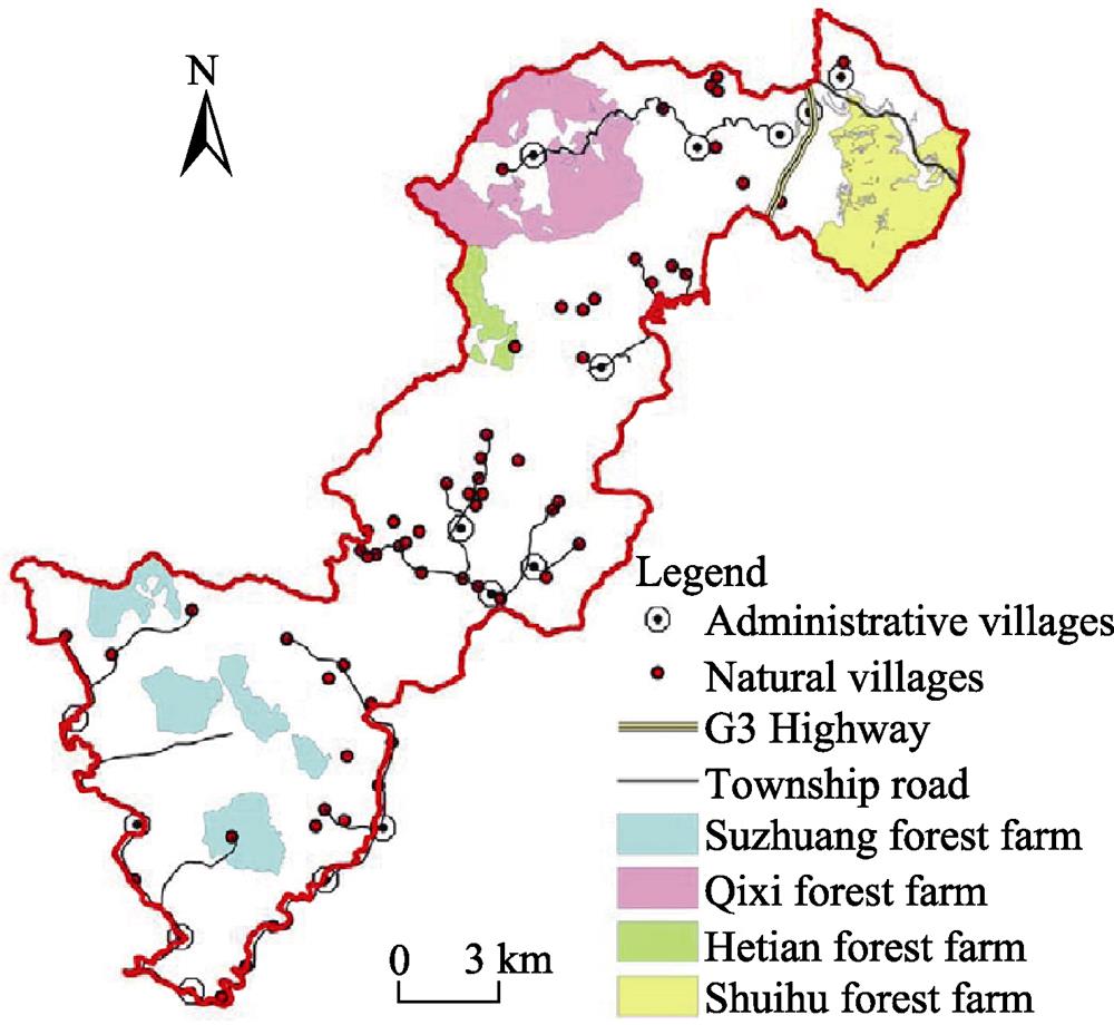
(2) Data on settlements and population. We obtained these data as follows: the research team conducted field research in each township and administrative village in QNP, distributing the questionnaires on population data to all village committees, and collecting the numbers of administrative villages and natural villages, as well as the number of settlements and the distribution of major roads. Finally, these data were entered into the main database.
(3) Data on distribution of natural resources. Digital elevation model (DEM) data for the 30-meter resolution of the study area was downloaded from the Geospatial Metadata Website and later integrated into the database for elevation analysis.
(4) Data on the distribution of important species. These data were mainly based on the findings of the terrestrial mammal resources survey of Gutian Mountain and Qianjiangyuan conducted by the Institute of Botany, Chinese Academy of Sciences.
(5) NPP (Net primary productivity). This was obtained by using the natural vegetation NPP model.
Above all, based on the vector data of the Second National Land Survey of Kaihua County, this paper adopted the spatial analysis platform of ArcGIS10.0 to cut down the scope of QNP. Finally, the above data was loaded into the ArcGIS to build the basic database.
2.3 Data analysis
Functional zoning mainly involves combining spatial superposition with mathematical statistics (such as cluster analysis, principal component analysis, and factor analysis) (
| Category | Weight | Indicator | Weight |
|---|---|---|---|
| Ecosystem | 0.15 | Carbon sequestration | 0.18 |
| Water conservation | 0.51 | ||
| Soil conservation | 0.31 | ||
| Potential habitat of important species | 0.30 | Distribution of ungulates | 0.47 |
| Distribution of birds | 0.37 | ||
| Distribution of fish | 0.16 | ||
| Ecological | 0.20 | Vegetation coverage | 0.43 |
| Rivers and lakes | 0.36 | ||
| Topography | 0.21 | ||
| Development opportunities | 0.15 | Population density | 0.20 |
| Traffic network density | 0.25 | ||
| Tourism resource density | 0.55 |
Table 1.
Evaluation index system on functional zoning of QNP
Firstly, as ecosystem service is the foundation for the establishment of national parks, we selected the three indicators of carbon sequestration, water conservation, and soil conservation for evaluation.
Secondly, some key nationally protected animals, such as white-necked pheasant, live in QNP, and their existence is an important indicator of the integrity of the regional ecosystem. Therefore, according to the importance of the wild species, 8 species and 3 taxa were screened for analysis. Meanwhile, buffer analysis on habitat was conducted to obtain the potential scope of protection for each species.
Thirdly, since ecological sensitivity reflects the ability of the ecosystem to adapt to human disturbance, and the more sensitive it is, the more vulnerable it is, ecologically sensitive areas are the areas where human activity must be restricted or prohibited. In this study, vegetation coverage, rivers and lakes, topography were chosen to conduct a comprehensive evaluation.
Fourthly, development opportunities reflect the potential of traditional life, recreation, and utilization, and can be expressed in terms of tourism resource density.
Fifthly, ecological sensitivity was calculated according to the natural regional characteristics of QNP, and three levels were created to determine the level of protection, namely, core protection, ecological conservation, and traditional utilization. Simultaneously, considering the community development of residential areas, utilization of ecological resources, and construction of service facilities, we identified the potential for the development of recreation to determine the recreation areas. Finally, the regulatory requirements and specific measures were designed in accordance with the need for protection and utilization.
3 Result
3.1 Regional characteristics analysis
The ecological characteristics of QNP were analyzed by establishing the evaluation index system of functional zoning. It was found that QNP is rich in vegetation types and includes typical forest vegetation types such as evergreen broad-leaved forests, temperate coniferous and broad-leaved mixed forests, temperate coniferous forests, and evergreen and deciduous broad-leaved mixed forests on mountains and in valleys. What is more, the spatial distribution of the ecosystem service of QNP is obvious, and the value of the ecosystem service is the highest in the Gutian Mountain Nature Reserve and the Qianjiangyuan National Forest Park (which are at each end of QNP), as they preserve the original subtropical low-altitude evergreen broad-leaved forest ecosystem, which is mainly located in the hillsides and foothills 165 to 1246 meters above sea level. In general, the forest coverage rate of QNP is 81.70%, and these forests play an important role in water conservation, soil and water conservation, biodiversity conservation, and air purification. However, in the middle connecting area, the capability of the ecosystem service has decreased significantly. In addition, the ecological corridor connecting the two ends has many secondary forests with a large number of settlements and transport infrastructures, and a certain level of tourism activities has been developed.
As shown in
![]()
Figure 2.
3.2 Ecological sensitivity analysis
According to the ecological sensitivity analysis of QNP, the ecologically sensitive area is moderate in size and mainly concentrated in the Gutianshan and Qianjiangyuan areas (
![]()
Figure 3.
| Sensitivity level | Area (km2) | Proportion (%) |
|---|---|---|
| Highly sensitive area | 59.23 | 23.53 |
| Medium sensitive area | 153.36 | 60.92 |
| Mildly sensitive area | 36.77 | 14.61 |
| Slightly sensitive area | 2.39 | 0.95 |
| Total | 251.75 | 100.00 |
Table 2.
Classification statistics of habitat sensitivity of QNP
3.3 Functional zone identification
In general, the functional zoning of national parks should be based on the characteristics of the natural regional ecosystems, the distribution of community settlements, and the scenic spots. Moreover, the zoning needs to reflect the dominant functions and regional relations, coordinating and controlling the land use to promote the conservation and utilization of resources. As for QNP, it should not only protect the ecosystem of low-elevation evergreen broad-leaved forests in the subtropics, but also meet the needs of large-scale national recreation in the east, and create sustainable livelihoods for a large number of communities in the region, mainly focusing on three aspects: protection, recreation, and community development. According to our analysis of the international approach to the zoning of national parks, it would be appropriate to adopt the four-point method of functional zoning: the core protected area, the ecological conservation area, the traditional utilization area, and the recreational display area. To ensure the integrity of the core protected area, the surroundings should create an ecological buffer zone, separating the core area from community development and recreation utilization. The relationship between functional zoning and ecological sensitivity is illustrated below (
![]()
Figure 4.
4 Discussion
(1) Index system establishment and partition modes have regional characters in relation to functional zoning of national parks, which is the adaptive selection to cope with ecological regional management under the administrative system of the state or region. The diversity of national parks in different countries is reflected in the following aspects:
![]()
Figure 5.
different natural geographical features, social economy and protected objects, and different requirements for functional zoning. However, in general, it is based on the three-circle structure proposed by the United Nations Educational Scientific and Cultural Organization. The tension between human activities and land determines the proportion placed in each functional area. At present, most national parks in the world are divided into 3-5 functional areas, namely ecological protection area, special landscape area, historical and cultural area, recreation area, and general control area. From the viewpoint of protection and utilization, they can be divided into strictly protected areas, important protected areas, restrictive utilization areas, and utilization areas. The degree of protection is gradually reduced, and the degree of utilization is gradually increased. Normally, the percentage of original forest habitat to maintain the sustainability of species and ecological processes is at least 50%-70%. As for China, it is confronted with a two-way tension between population development and land use. While protecting the natural ecological space in national parks, community development must be considered, and recreational activities should be developed in moderation to meet the needs of national life and leisure. However, functional zoning of national parks needs to prioritize maintenance of the natural ecological process. When this ecologically sensitive core area has been identified, then land for community use and tourism can be allocated. Therefore, this paper identifies four functional areas of the QNP according to the ecological sensitivity evaluation model: the core area, ecological conservation area, recreational environment, and traditional utilization area. Meanwhile, it is necessary to implement conservation or utilization activities in the different functional areas according to the dominant features to ensure the sustainable development of natural ecosystems in the future.
(2) From the aspect of regional differences, QNP is located in Eastern China, which is a “small scale region”. The proposed national park functional zoning method is based on ecological sensitivity, taking into account the natural resources and environmental elements to identify the different functional areas. It differs from previous methods, such as the analytic hierarchy process and the artificial judgment method based on ecological integrity and the biodiversity and ecological carrying capacity, which can better optimize the management of the ecological environment. The article is based on ecological sensitivity evaluation and identification of four functional areas of QNP, the proportion of the different areas is 3:3:3:1, which is practical in terms of maintaining ecosystem integrity and meeting recreational needs. However, QNP is different from China’s national parks in western regions, which possess different natural resources, land area, and population size. However, whether the functional zoning method is appropriate to the national parks in Qinghai-Tibet Plateau or the Sanjiangyuan region, needs further discussion.
(3) The essence of national park control is classified hierarchical management, and the target of functional zoning is to determine the protection goals of different levels on the basis of balanced and sustainable use. The aim is to support control decisions, ensure the subsequent land ownership adjustment, space layout, partition management, and community relocation compensation, and to maximize the effectiveness of the national park. In addition, the function partition management is important for the regional planning, construction, and management of the technical method (
5 Conclusions
This paper establishes an evaluation index system based on ecological sensitivity, combining ecosystem services, potential habitats of important species, and development opportunities of QNP and identifies different levels of sensitivity. It found that ecologically sensitive regions have cross-sectional differences in space and can be divided into four grades, namely highly sensitive area, medium sensitive area, mildly sensitive area, and slightly sensitive area; their percentages were 23.53%, 60.92%, 14.61%, and 0.95%, respectively. Based on the classification of ecological sensitivity, functional zoning can be implemented. Highly sensitive areas can be defined as core protection areas, and mildly sensitive and low-sensitive areas can act as traditional community use areas and recreation areas.
The key point of this paper is to propose that conservation or utilization activities should be set up according to the dominant characteristics of different functional areas to ensure the sustainable development of the natural ecosystem in the future. National park management should meet diversified functional requirements, and cannot unilaterally emphasize protection or utilization, both of which can have adverse effects on the natural ecosystem and/or regional development. Zoning in the national park should focus on the reference intensity of different functional areas of ecological sensitivity, and then allocate a reasonable space for scientific research, education, tourism, and other activities. These can ensure a good balance between human activity intensity and land-use intensity, and ensure that the national park can achieve sustainable evolution within its carrying capacity.
References
[2] DeardenP. Parks and protected areas in Canada: Planning and management(1993).
[3] Fu MD, Tian JL, Zhu YP et al. Functional division and management of Sanjiangyuan National Park. Biodiversity Science, 25, 71-79(2017).
[5] Hong JM, Ran DY. Ecological tourism planning and design(2005).
[6] Kathirithamby-WellsJ. Nature and nation:Forests and development in Peninsular Malaysia(2005).
[7] Liu HY. The development and management of Canada’s national parks and its implication in China. Chinese Journal of Ecology, 20, 50-55(2001).
[8] Luo JH. A study on the establishment and the standards for national parks in China. Fuzhou: Fujian Normal University(2013).
[9] McNamee K.1993. From wild places to endangered spaces: A history of Canada’s national park. In: Dearden P. (ed.). Parks and protected areas in Canada: Planning and management.
[10] NabokovP, LoendorfL. Restoring a presence: American Indians and Yellowstone National Park(2004).
[11] Paul F J.Eagles, WangZ et al. Sustainable tourism in protected areas guidelines for planning and management(2005).
[12] Wagner FredericH, Hamilton WayneL, Jeigley RichardB. Yellowstone’s destabilized ecosystem: Elk effects, science, and policy conflict(2006).
[13] WallG. Recreational land use: Perspectives on its evolution in Canada(1982).
[14] Wang WZ. National Park(2000).
[15] WarwickF, C. MichaelH. Tourism and national parks: International perspectives on development, histories and change. London: Routledge.(2009).
[17] Zhang JH, BaiL. A general picture of Japan natural park. Journal of Chinese Landscape Architecture, 18, 87-90(2002).
[19] Zhang AP, Zhong LS, XuY et al. Functional zoning of ecotourism areas in the First Meander of the Yellow River based on suitability analysis. Acta Ecologica Sinica, 35, 6838-6847(2015).


Set citation alerts for the article
Please enter your email address

© Copyright 2018-2021 | Chinese Laser Press. All Rights Reserved 沪ICP备15018463号-20