• Geographical Research
  • Vol. 39, Issue 10, 2379 (2020)
Xinmeng TU, Xuhong YANG*, Jingyuan ZHANG, Xinchen LUAN, and Kexin NING
Author Affiliations
  • School of Geography and Ocean Science, Nanjing University, Nanjing 210023, China
  • show less
    DOI: 10.11821/dlyj020190189 Cite this Article
    Xinmeng TU, Xuhong YANG, Jingyuan ZHANG, Xinchen LUAN, Kexin NING. Analyzing geographical characteristics of straw burning in China during 2014-2019[J]. Geographical Research, 2020, 39(10): 2379 Copy Citation Text show less
    Overall procedure of this research
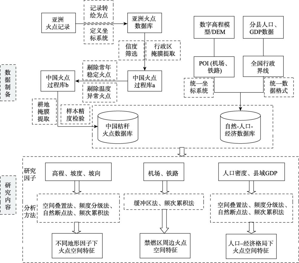
    Fig. 1. Overall procedure of this research
    Spatial distribution characteristics of fire points at different elevations (a), slopes (b), slope aspects (c)
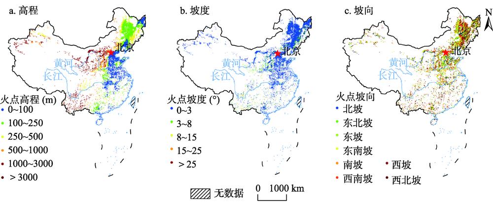
    Fig. 2. Spatial distribution characteristics of fire points at different elevations (a), slopes (b), slope aspects (c)
    序号数据名称数据格式时空尺度数据源
    1SatSee-Fire火点.csv亚洲区、2014年1月1日至2019年12月31日http://satsee.radi.ac.cn:8080/index.html
    2中国行政界线.shp分省http://www.resdc.cn/data.aspx?DATAID=200
    3数字高程模型.grid90 m × 90 m网格http://www.resdc.cn/data.aspx?DATAID=123
    4机场.shp2016年全国POIhttp://www.resdc.cn/data.aspx?DATAID=240
    5铁路.shp2016年全国POIhttp://www.resdc.cn/data.aspx?DATAID=236
    6中国人口和GDP.grid1 km × 1 km网格,2015年http://www.resdc.cn/data.aspx?DATAID=252
    7中国耕地.grid1 km × 1 km网格,2015年http://www.resdc.cn/data.aspx?DATAID=184
    Table 1. Description of related attributes of basic data
    地形因子单位范围火点数(个)比例(%)
    高程m0~100901034.32
    100~200915934.88
    200~300279310.64
    300~40011934.54
    400~50019437.40
    500~6004391.67
    600~7002170.83
    700~8002921.11
    800~9003231.23
    900~10008863.37
    坡度°0~32690193.53
    3~815965.55
    8~152080.72
    15~25520.18
    > 2540.01
    坡向602120.93
    东北292410.17
    316611.01
    东南407414.17
    370912.90
    西南296010.29
    西25858.99
    西北332211.55
    Table 2. Distribution of fire points at different elevations, slopes, and slope aspects
    禁燃区因素单位范围火点数(个)比例(%)
    机场km0~130.03
    1~2200.21
    2~3470.50
    3~4780.83
    4~51281.36
    5~62302.44
    6~73553.77
    7~84995.30
    8~96416.81
    9~107768.24
    10~1194710.06
    11~12113912.10
    12~13135014.34
    13~14147715.69
    14~15172318.30
    铁路m0~20028510.59
    200~40033612.49
    400~6002469.14
    600~8002679.92
    800~100029210.85
    1000~120027110.07
    1200~14002679.92
    1400~16002609.66
    1600~18002368.77
    1800~20002318.58
    Table 3. Distribution of fire points in each buffer in the forbidden area of nationwide airports and railways
    社会经济因素单位范围火点数(个)比例(%)
    县域人口密度人/km²0~2502003069.85
    250~500449515.68
    500~75023868.32
    750~10008492.96
    1000~12502460.86
    1250~1500890.31
    1500~17501790.62
    1750~2000250.09
    2000~22501740.61
    >22502020.70
    县域GDP水平百亿元0~1.01667958.17
    1.0~2.0628821.93
    2.0~3.0291710.17
    3.0~5.014345.00
    5.0~7.58603.00
    7.5~10.0870.30
    10.0~12.51190.42
    12.5~15.01110.39
    15.0~20.0510.18
    >20.01280.45
    Table 4. Distribution of fire points with different county population densities and county GDP
    Xinmeng TU, Xuhong YANG, Jingyuan ZHANG, Xinchen LUAN, Kexin NING. Analyzing geographical characteristics of straw burning in China during 2014-2019[J]. Geographical Research, 2020, 39(10): 2379
    Download Citation