• Journal of Geo-information Science
  • Vol. 22, Issue 10, 2051 (2020)
Zihui GUO1 and Wei LIU1、2、*
Author Affiliations
  • 1School of Geographic Mapping and Urban Rural Planning, Jiangsu Normal University, Xuzhou 221116, China
  • 2State Key Laboratory of Resources and Environmental Information Systems, Institute of Geographic Sciencesand Natural Resources Research, Chinese Academy of Sciences, Beijing 100101, China
  • show less
    DOI: 10.12082/dqxxkx.2020.200001 Cite this Article
    Zihui GUO, Wei LIU. Land Type Interpretation Authenticity Check of Vector Patch Supported by Deep Learning and Remote Sensing Image[J]. Journal of Geo-information Science, 2020, 22(10): 2051 Copy Citation Text show less
    A sketch of the task of checking the authenticity of the land type interpretation of vector patches
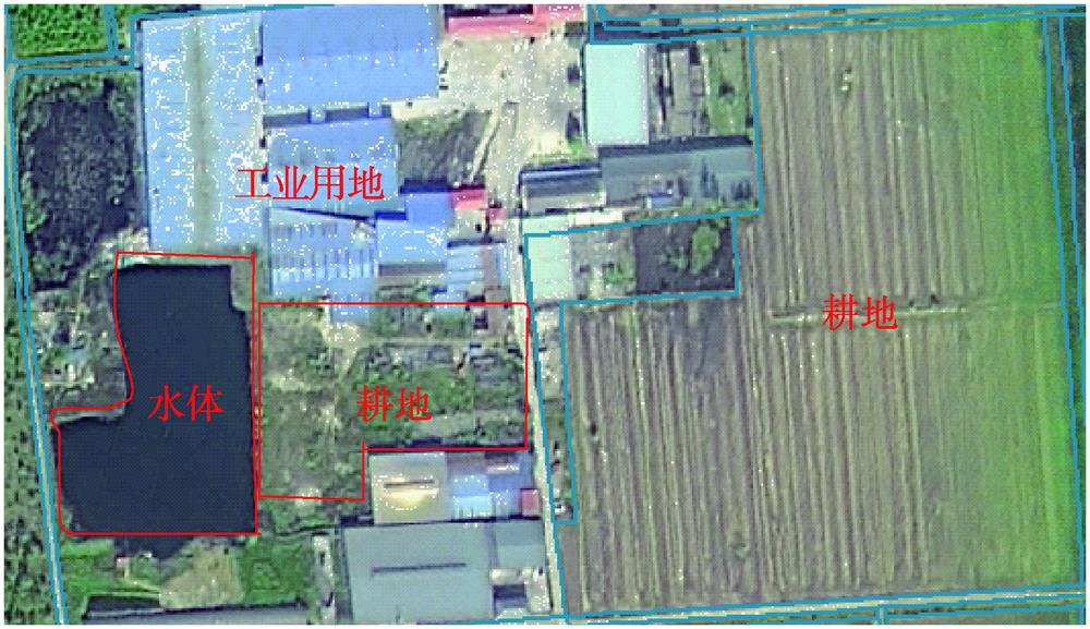
    Fig. 1. A sketch of the task of checking the authenticity of the land type interpretation of vector patches
    The technical route of the check of the authenticity of the land type interpretation of vector patches
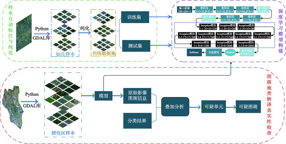
    Fig. 2. The technical route of the check of the authenticity of the land type interpretation of vector patches
    Research area overview and samples
    Fig. 3. Research area overview and samples
    Purification process of self-labeled samples
    Fig. 4. Purification process of self-labeled samples
    Inception module
    Fig. 5. Inception module
    Structure diagram of the Inception_v3 model
    Fig. 6. Structure diagram of the Inception_v3 model
    Effect of learning rate attenuation coefficient on model accuracy
    Fig. 7. Effect of learning rate attenuation coefficient on model accuracy
    Inception_v3 learning rate dynamic curve
    Fig. 8. Inception_v3 learning rate dynamic curve
    Training accuracy change of Inception_v3 model
    Fig. 9. Training accuracy change of Inception_v3 model
    Optimal grid schema in authenticity check of geographic interpretation
    Fig. 10. Optimal grid schema in authenticity check of geographic interpretation
    Some suspicious spots
    Fig. 11. Some suspicious spots
    Land use types with low characteristic differentiation
    Fig. 12. Land use types with low characteristic differentiation
    The results of the check of the authenticity of the land type interpretation of vector patches in Dawu Town
    Fig. 13. The results of the check of the authenticity of the land type interpretation of vector patches in Dawu Town
    类别训练集数量验证集数量测试集数量合计
    工业用地7971002001097
    林地7631082171088
    耕地90331214242912 676
    水体66594189948
    住宅用地22223176343173
    合计13 4801833366918 982
    Table 1. [in Chinese]
    学习方法模型验证集精度测试集精度
    迁移学习VGG160.9160.902
    Inception_v30.9660.934
    Table 2. Comparison of model effects used in scene classification
    参数名称批处理值/(个/次)步数/初始/学习率学习率/衰减系数学习率衰减速度/(步/次)
    参数值100200 0000.100.9010 000
    Table 3. Super parameter information
    精确率(P)召回率(R)F1准确率(OA)
    工业用地0.9090.8750.8920.934
    林地0.9650.9250.945
    耕地0.9290.9360.933
    水体0.8990.9100.905
    住宅0.9810.9940.987
    均值0.9370.9280.932
    Table 4. Model classification results
    准确率(A)精确率(P)召回率(R)
    0.7660.9250.817
    Table 5. Effect of the check of the authenticity of the land type interpretation of vector patches
    Zihui GUO, Wei LIU. Land Type Interpretation Authenticity Check of Vector Patch Supported by Deep Learning and Remote Sensing Image[J]. Journal of Geo-information Science, 2020, 22(10): 2051
    Download Citation