• Journal of Natural Resources
  • Vol. 35, Issue 10, 2339 (2020)
Xiao-qing ZHAO1、*, Si-nan LI1, Jun-wei PU2, Shu-cheng TAN1, and Jun-xu CHEN1
Author Affiliations
  • 1College of Earth Science, Yunnan University, Kunming 650500, China
  • 2Institute of International Rivers & Eco-security, Kunming 650500, China
  • show less
    DOI: 10.31497/zrzyxb.20201004 Cite this Article
    Xiao-qing ZHAO, Si-nan LI, Jun-wei PU, Shu-cheng TAN, Jun-xu CHEN. Optimal partitions and control of territorial space in karst mountainous areas of Yunnan province[J]. Journal of Natural Resources, 2020, 35(10): 2339 Copy Citation Text show less
    Location of the study area
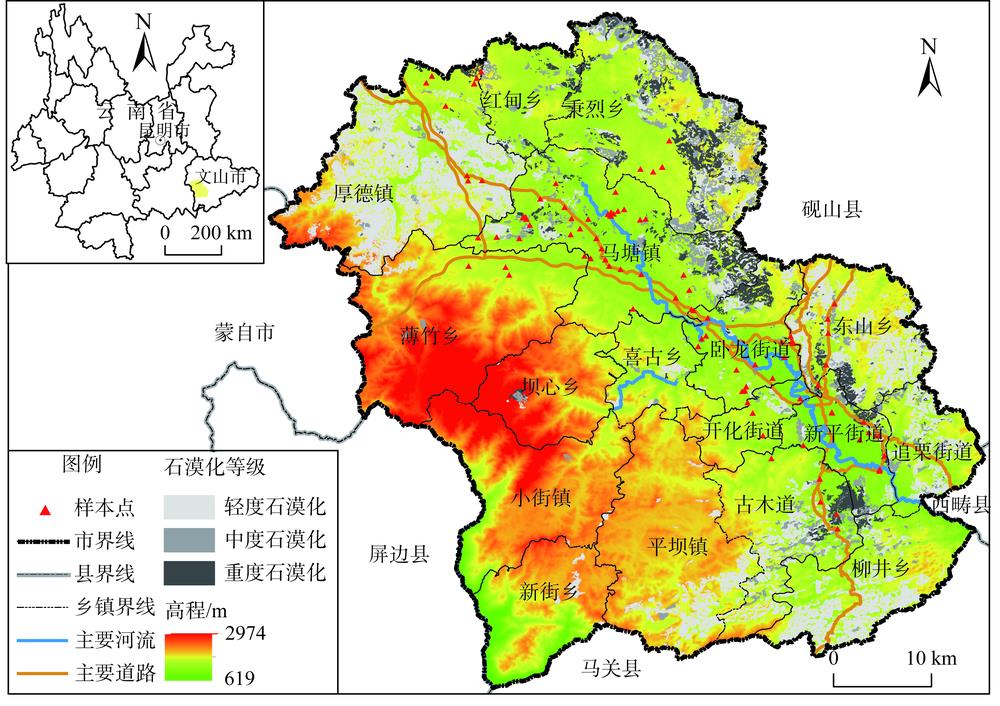
    Fig. 1. Location of the study area
    Study framework
    Fig. 2. Study framework
    Distribution of the territorial spatial suitable types and the grades of resources and environment carrying capacity
    Fig. 3. Distribution of the territorial spatial suitable types and the grades of resources and environment carrying capacity
    Quantity structures of territorial space optimization in karst mountainous areas
    Fig. 4. Quantity structures of territorial space optimization in karst mountainous areas
    Distribution of territorial spatial optimization zones in karst mountainous areas
    Fig. 5. Distribution of territorial spatial optimization zones in karst mountainous areas
    Distribution of territorial spatial functional types in rocky desertification areas
    Fig. 6. Distribution of territorial spatial functional types in rocky desertification areas
    石漠化等级指标
    植被+土被覆盖率岩石裸露率
    轻度石漠化35~5030~50
    中度石漠化20~3550~70
    重度石漠化<20>70
    Table 1. Classification standards of rocky desertification levels (%)
    目标准则指标获取方式趋向权重
    城镇开发适宜性条件限制自然地理坡度/(°)DEM-0.0935
    生命安全地质灾害易发区资料收集-0.0693
    活动断层影响区资料收集-0.0451
    岩溶塌陷易发区资料收集-0.0503
    矿山占用地资料收集+0.0627
    生态安全及粮食安全生态保护红线区资料收集-0.0337
    永久基本农田区资料收集-0.0579
    现状地类遥感解译+0.0623
    区位支撑地理区位距中心市区距离/m缓冲区-0.1634
    距建制镇距离/m缓冲区-0.1105
    距农村居民点距离/m缓冲区-0.0673
    交通区位距国道/省道距离/m缓冲区-0.1305
    距县道/乡道距离/m缓冲区-0.0535
    Table 2. Evaluation index system of urban development suitability in karst mountainous areas
    目标准则指标获取方式趋向权重
    农业开发适宜性土壤管理情况灌溉保证率/%资料收集+0.0983
    区位支撑距居民点距离/m缓冲区-0.0235
    距农村道路距离/m缓冲区-0.0697
    距现状耕地距离/m缓冲区-0.0237
    立地条件坡度/(°)DEM-0.0350
    坡向DEM+0.0253
    高程/mDEM-0.0479
    气候条件年10 ℃积温/℃资料收集+0.1033
    年降雨量/mm数据插值+0.0710
    土壤养分状况有机质有机质含量/(g/kg)资料收集+0.0438
    大量元素全氮含量/(g/kg)资料收集+0.0252
    有效磷含量/(mg/kg)资料收集+0.0863
    速效钾含量/(mg/kg)资料收集+0.0799
    微量元素有效锌含量/(mg/kg)资料收集+0.0539
    水溶态硼含量/(mg/kg)资料收集+0.0531
    土壤剖面及理化性状土壤质地资料收集+0.0442
    土层厚度/cm资料收集+0.0685
    剖面构型资料收集+0.0157
    pH值资料收集+0.0317
    政策管控永久基本农田资料收集+
    Table 3. Evaluation index system of agricultural development suitability in karst mountainous areas
    目标准则指标获取方式趋向权重
    生态保护
    适宜性
    生态敏感性水土流失敏感性土壤侵蚀量/(t/hm2)RUSLE+0.0838
    地质灾害敏感性资料收集+0.0331
    石漠化敏感性遥感解译+0.0995
    生态重要性水源涵养功能重要性水源涵养量/(m3/hm2)降水储存+0.1419
    土壤保持功能重要性土壤保持量/(t/hm2·a)RUSLE+0.1735
    生物多样性维护重要性生境质量指数HQI+0.1253
    自然保护区分布资料收集+0.1066
    公益林分布资料收集+0.0605
    固碳释氧服务重要性净初级生产力/[g C/(m2·a)]NPP+0.1758
    政策管控生态保护红线资料收集+
    Table 4. Evaluation index system of ecological protection suitability in karst mountainous areas
    目标准则指标趋向权重
    资源环境承载力评价资源承载力水资源地均水资源量/(m3/hm2)+0.0653
    人均水资源量/(m3/人)+0.0225
    供水比例/%+0.0236
    万元GDP用水量/(m3/万元)-0.0576
    土地资源耕地资源/%+0.0373
    建设用地资源/%+0.0382
    旅游资源旅游资源吸引力+0.0373
    区位资源距道路距离/m+0.0396
    距水源距离/m+0.0391
    矿产资源查明矿产资源价值/万元+0.0585
    环境承载力生态环境植被净初级生产力/[g C/(m2·a)]-0.0420
    生境质量指数-0.0519
    水土流失环境产水量/mm+0.0333
    土壤保持量/[t/(hm2·a)]+0.0187
    石漠化程度-0.0282
    水环境地表水环境质量+0.0199
    人均污水排放量/(m3/人)-0.0052
    大气环境SO2/(μg/m3)-0.0190
    NO2/(μg/m3)-0.0195
    PM10/(μg/m3)-0.0193
    CO/(μg/m3)-0.0195
    O3-8h/(μg/m3)-0.0193
    PM2.5/(μg/m3)-0.0187
    地质环境地质灾害易发率/%-0.0188
    社会经济承载力社会状况城镇化率/%+0.0856
    人均粮食占有量/(kg/人)+0.0189
    劳动力比例/%+0.0196
    人口密度/(人/km2)-0.0196
    经济状况GDP增长率/%+0.0229
    第三产业增加值/%+0.0467
    居民可支配收入/万元+0.0344
    Table 5. Evaluation index system of the resources and environment carrying capacity in karst mountainous areas
    序号资源环境承载力等级功能区定位国土空间潜在发展类型
    1I生态环境保护的重点区生态保护红线区
    2II一般生态维护区一般生态区
    3III一般农业生产用地和农村生活用地一般农业区
    4IV农业开发和种植核心区永久基本农田区
    5V城镇开发建设留白区城镇预留区
    6VI城镇开发建设核心区城镇开发边界区
    Table 6. Amendment rules of territorial spatial conflict zones
    国土空间功能类型国土空间发展模式
    现状模式优化模式
    城镇空间2.228.26
    农业空间45.5043.71
    生态空间52.2848.03
    Table 7. Comparison of the present structures and optimization results of territorial spatial functional types in karst mountainous areas (%)
    Xiao-qing ZHAO, Si-nan LI, Jun-wei PU, Shu-cheng TAN, Jun-xu CHEN. Optimal partitions and control of territorial space in karst mountainous areas of Yunnan province[J]. Journal of Natural Resources, 2020, 35(10): 2339
    Download Citation