
Xinyuan LIANG, Yangbing LI, Jing’an SHAO, Caihong RAN. Traditional agroecosystem transition in mountainous area of Three Gorges Reservoir Area[J]. Journal of Geographical Sciences, 2020, 30(2): 281
- Journal of Geographical Sciences
- Vol. 30, Issue 2, 281 (2020)
Abstract
Keywords
1 Introduction
Agroecosystem is a complex ecosystem with high degree of human intervention that integrates natural resources such as cultivated land, woodland and water (
In the mountainous areas of western Japan, due to social changes that include population decline, grassland and farmland exposed to “slash and burn” have been transformed into coniferous forests, while other areas have been completely abandoned and transformed into deciduous forests through succession (
The Three Gorges Reservoir Area is typical of an ecologically vulnerable area, comprised of rural and mountainous areas with high immigration. It also has the highest concentration of poor counties in China (
2 Theoretical analysis
2.1 A theoretical model for agroecosystem evolution in mountainous areas
In recent years, mountainous areas have shown a reversing land use trend, from an initial expansion of cultivated land and shrinkage of forest land to the contraction of cultivated land and expansion of forest land. Differing factors, such as the abandonment of cultivated and and development of fruit forest, are the microscopic mechanisms that lead to these forest transitions in mountainous areas. In addition, a large-scale shift in labor demand due to socio-economic factors has alleviated human disturbances of land, influenced farmer livelihoods, and is the most direct driving force for changes in mountain land use (
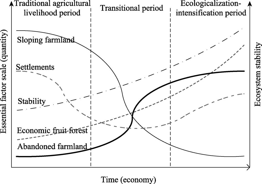
During the traditional agricultural livelihood period, sloping farmland was the primary source of production in the agroecosystem. However, the characteristics of sloping farmland have caused significant ecological and environmental problems in the development and utilization of mountain land. During the transitional period of agricultural social development, cultivated land area has been decreasing with economic fruit forests and abandoned farmland replacing the reduced area of sloping farmland, which has generally improved the stability of the agroecosystem (
![]()
Figure 1.
2.2 The evolution of the agroecosystem in the TGRA
Recently, the rural human-land relationship in the hinterland of the TGRA has changed subtly (
![]()
Figure 2.
The goal of this study is to deconstruct the multiple elements of the traditional agroecosystem in mountainous areas from the perspective of dynamic landscape change, evaluating the interacting mechanisms driving human-land relationship change in the TGRA. Different from the traditional land use transformation research framework, we emphasize the farmer subject in pursuit of ecological and economic benefits as the basis for explicit changes in land use. We propose that focusing on this subject will provide an important supplement to forest and land use transition research.
3 Materials and methods
3.1 Geography of the study region
The Caotangxi River Basin is located in Caotang Town, east of Fengjie County, Chongqing Municipality, which is in the hinterland of the TGRA. It belongs to the first tributary of the Yangtze River. The total length of the river is 33.3 km and encompasses a total area of approximately 210 km2 (
![]()
Figure 3.
3.2 Data sources and processing
This study used QuickBird high-definition remote sensing imagery as the data source, mainly Google Earth remote sensing data from 2012 and 2017 with a resolution accuracy of 0.51 m. Referring to the land use classification methods described in the Resource and Environment Information Database of the Chinese Academy of Sciences, land use in the study area was divided into 12 types including cultivated land, shrub land, forest land, orchard, abandoned farmland, township settlements, and rural settlements, using the man-computer interactive interpretation. Finally, the land use interpretation results were sampled and verified by field inspection in August 2017; the interpretation accuracy of land use types in each period was over 92%.
3.3 Research methods
3.3.1 Classifying settlements attributes
The development status and characteristics of spatial distribution of settlements can be revealed by analyzing changes at different stages. Therefore, the activity and status of different settlements were determined according to field reconnaissance and literature describing the study area. We used
| Settlement type | Identification standard | Sources | Interpretation reference |
|---|---|---|---|
| Decline | Signs of cultivation near settlements are disappearing and abandoned land trends are clear; the landscape tends to be monotonous; the colors of residential locations are dim; and surrounding roads are gradually replaced by “forest-shrub-grass”. | CNES AstriumQuick Bird(0.51 m) |  |
| Stagnation | The distribution of the surrounding farmland is scattered and there are no signs of consolidation; the overall landscape pattern is balanced; the colors of residential locations are generally dark; and infrastructure construction is declining. |  | |
| Development | The surrounding farmland shows order and there are signs of consolidation; a weak fruit forest planting trend appears; the ecological landscape tends to be diverse; the colors of the residential locations are white; and individual homes are clear. |  | |
| Vigor | Clearly fruit forest planting trend near the settlements; the surrounding infrastructure is complete; the landscape is diverse; the colors of residential locations are bright; and the stereo perception of the settlements is strong. |  |
Table 1.
Reference standards for different settlement attributes
3.3.2 Spatial identification of farmer livelihoods
Matching spatial results of farmer livelihood patterns with survey data can improve the authenticity of farmer livelihood data. Based on the characteristics of the study area and after repeated simulations, the ratio of the cultivated land to the total area within the 300 m buffer zone centered on the settlement was 95.2%. Therefore, the 300 m range around the settlement was regarded as the farmer’s tillage radius. Spatial association technology was then used to calculate the land use ratio of the abandoned land within the tillage radius range of each settlement. These parameters combined with the settlement attributes were used to determine farmer livelihood classifications. As indicated from previous work, a greater settlement recession rate correlates with a lesser likelihood that a migrant farmer will return (
The specific judgement criteria are shown in
![]()
Figure 4.
(1) Working. Generally, no cultivated land is found around the decline-type settlements, and the abandonment rate is high; the farmers are more likely to go out to work.
(2) Part-time.
a) Due to the lack of consolidation of cultivated land around the stagnation-type settlements, the abandonment rate increases; that is, traditional farming and migrant workers coexist.
b) The vigor-type settlements are mainly surrounded by economic fruit forest. At the same time, the abandonment rate increases, and the area of cultivated land shrinks; that is, modern agricultural and working farmers coexist
(3) Diversified. The proportion of cultivated land around the development-type settlements decreases and the proportion of economic fruit forest and abandoned farmland increases; the cultivated land changes to forest and grassland, and the vegetation coverage increases; modern agricultural development coexists with farming and working.
When the abandonment rate within the tillage radius of a single settlement is less than the average value of the abandonment rate within the tillage radius of all settlements, there are three farmer classifications:
(1) Part-time. The abandonment rate around decline-type settlements has decreased although some cultivated land remains; that is, the traditional type and working type coexist.
(2) Traditional. The abandonment rate around stagnation-type settlements is low, the vegetation coverage rate is low, the landscape type is simplified, and the cultivated land area is large.
(3) Intensive. The abandonment rates around development and vigor settlements are low, the cultivated land is concentrated, the degree of fragmentation is reduced, and the fruit forest area is larger.
3.3.3 Division of agroecosystem research units
To integrate different agroecosystem components, the land use degree (LUD) model proposed by
| Settlement type | Identification standard | Sources | Interpretation reference |
|---|---|---|---|
| Decline | Signs of cultivation near settlements are disappearing and abandoned land trends are clear; the landscape tends to be monotonous; the colors of residential locations are dim; and surrounding roads are gradually replaced by “forest-shrub-grass”. | CNES AstriumQuick Bird(0.51 m) | |
| Stagnation | The distribution of the surrounding farmland is scattered and there are no signs of consolidation; the overall landscape pattern is balanced; the colors of residential locations are generally dark; and infrastructure construction is declining. | | |
| Development | The surrounding farmland shows order and there are signs of consolidation; a weak fruit forest planting trend appears; the ecological landscape tends to be diverse; the colors of the residential locations are white; and individual homes are clear. | | |
| Vigor | Clearly fruit forest planting trend near the settlements; the surrounding infrastructure is complete; the landscape is diverse; the colors of residential locations are bright; and the stereo perception of the settlements is strong. | |
Table 1.
Reference standards for different settlement attributes
where L is the LUD within a single quadrant; Ai and Ci are respectively the i-th land use intensity grading index and the percentage of the area in the quadrant; Si is the i-th land use type area within the quadrant; and S is the total area of land in the quadrant.
Taking into account the coverage of the 300 m tillage radius, each settlement farming area was used as a research unit for the agroecosystem. Given that the actual area of each buffer ring is small, the calculated LUD values are relatively close; if a large-scale quantitative classification is conducted, it will affect the judged regularity of the data. Therefore, the LUD values of the buffer rings were compared to assign values to the agroecosystem model. Concurrently, based on the size of the LUD in the 100 m equal-distance buffer ring, the agroecosystem was divided into four modes: low-low- high (LLH), low-high-low (LHL), high-high-low (HHL), and high-low- high (HHL). The definitions of high and low values are relative concepts, and the main purpose is to present the dynamic evolution of the agroecosystem (
![]()
Figure 5.
Micro-scale changes in agroecosystems are often difficult to observe using objective measures. In this case, we use the settlement as the core and the LUD around it to represent the degree of human disturbance on landscape changes, including human or natural landscape evolution on sloping farmland and forest land. In our four defined modes, a high value indicates that the buffer ring has a higher proportion of human landscape, the proportion of sloping farmland and construction land is large, the ecological vitality of the settlement system is weak; here, farmers behave simply and focus on the traditional cultivation of sloping farmland. In contrast, a low value indicates that the proportion of natural landscape is high, e.g., forest, shrub, and grass areas are large; here, farmers show diverse behavior, the ecological awareness of land use is better, and the ecological vitality of the settlement system is strong.
3.3.4 Landscape transect analysis
The micro-scale agroecosystem transition modes based on settlement units focuses on analyzing changes in individual systems; therefore, it cannot show dynamic changes in the overall traditional agroecosystem within a regional context. To address this limitation, the evolution trend of agroecosystem was analyzed by selecting some regions with severe disturbances from human activity. The transect selection covered the typical geomorphology of the study area and the dynamic landscape changes were relatively significant. The specific orientation is northwest-southeast, with the trend generally parallel to the ridgeline. The transect window size was set to cover the range of slopes with the most significant human disturbances and subsequent changes, so the bandwidth was set to 0.5 km, length to 1.5 km, and window size to 500 × 500 m (
![]()
Figure 6.
4 Results
4.1 Agroecosystem transition mode
The resource elements centered on settlements were integrated into a complete human-land system using the LUD model, and are regarded as independent agroecosystem units. Examples of different agroecosystem modes are shown in
![]()
Figure 7.
| Land grade | Unused | Natural | Agricultural | Construction |
|---|---|---|---|---|
| Land use type | Unused land | Forest land, grass land, water and abandoned farmland | Sloping farmland, orchard and economic fruit forest | Urban land, rural residential land, industrial and mining land and transport land |
| Graded index | 1 | 2 | 3 | 4 |
Table 2.
Classification of land use degree
4.2 Evolution of the agroecosystem spatial distribution
The agricultural transformation trends in the study area at the landscape level were analyzed with the moving window method (
![]()
Figure 8.
Due to limitations of topography and geomorphology in the high-elevation areas of the study area, humans have difficulty exploiting the natural landscape and the landscape type remains dominated by forests. The middle-elevation areas are dominated by traditional settlement-cultivated agricultural landscapes. In contrast, the landscapes of cultivated land near the low-elevation valley flatland areas gradually changes, with the more degenerative cultivated land landscapes that include substitution types, such as AF and EFF. This phenomenon is closely related to the binding factors, such as the natural slope of the mountain. Concurrent with the transformation of the traditional agroecosystem, forest land in the middle and high elevation areas has changed from cultivated land abandonment to restorative growth. Therefore, the landscape types in the middle- and low-elevation areas are more diverse and characterized by the modern mountainous agricultural landscape, combining EFF-Settlement-Cultivated Land-FSGL. The transition process defined by the traditional agricultural landscape is gradually transforming into a natural forest landscape dominated by FSGL due to the limitation of natural conditions. That is, a transition from a degenerative cultivated land landscape to a semi-naturalized modern agricultural landscape through agricultural land use conversion and farmland abandonment.
4.3 The regularity of the agroecosystem transition
By analyzing the relationship between different agroecosystem modes, topographical features, and various resource elements, we explore the agroecosystem transition in more detail (Figures 9 and 10). Due to terrain constraints, settlements in the study area have been mainly concentrated in the slope range of 10°-35°. Between 2012 and 2017, the number of LLH and LHL modes in the low-elevation areas gradually decreased; the LLH and LHL modes shifted from stagnation-type and development-type settlements to vigor-type settlements, and more farmer livelihoods were of the intensive type. The HLL and HLH modes became concentrated in development, stagnation, and decline-type settlements, and the farmer livelihoods generally transitioned from traditional to the part-time and intensive types. In the 100 m range through the EFF planting region, the modes ranked as: LLH >LHL >HLH >HLL; the relationship between each mode and distance from the AF changed from an inverted U-shaped distribution to a negative correlation trend.
![]()
Figure 9.
![]()
Figure 10.
In summary, there are certain coupling relationships between different modes of agroecosystems and their subsystems. Combining the results described in sections 4.1 and 4.2, we find that the agroecosystem in the study area is gradually transforming from Form-A (pure agricultural livelihood for extensive use in traditional farming areas) to Form-B (intensive use for logical planting structures and species diversity around settlements) through ecological restoration methods, such as SF abandonment and EFF planting. Overall, the LLH and LHL agroecosystem modes are more applicable to agricultural development in the TGRA.
5 Discussion
5.1 Transition mechanisms and agroecosystem trends in the TGRA
The transition of Form-A to Form-B can be viewed as a process of transforming rural land use and farmer livelihoods from traditional farming to modernized new agriculture and diverse livelihoods (
![]()
Figure 11.
5.2 Research prospects
At present, sustainable intensification of agroecosystems has gradually become a paradigm for agroecosystem development on a global scale, which emphasizes the sustainability and resilience of landscapes, biospheres, and the Earth system (
Rural agricultural development in the TGRA is representative of rural land use transition on a small scale and reflects the evolution process of rural agroecosystems in mountainous areas. The vitalization of settlements structure, the diversification trends in farmer livelihoods, and the evolution of SF-EFF-AF’s mountainous agroecosystem are key elements of the transition from traditional agroecosystem in typical mountainous areas such as the TGRA, which are different from agroecosystem changes in other areas. These observations provide additional regional evidence for the conclusion that “China is turning green” (
Nonetheless, our research has some limitations. First, the basis for the spatial evaluation of farmer livelihoods was the settlement-based farmer livelihood status. Although there is a certain empirical error using this metric, the slight adjustment after field verification can be generally applied to the evaluation process in large-scale mountainous areas. Second, the spatial characterization of the traditional agroecosystem in this mountainous area was based on dividing buffer units around the settlement; then, smaller scale changes in elements within the regional agroecosystem were integrated. Therefore, the limiting factors of the farming distance in the study area may have impacted the definition of the agroecosystem, although it would not have affected its own reference value.
6 Conclusions
Using a framework of theoretical analysis, empirical study, and trend prediction, this study analyzed the evolution of the traditional agroecosystem in the TGRA from the perspective of changing human-land relationships. We obtained the following conclusions:
(1) Taking the typical watershed of the Caotangxi River as our study area, we found that farmland abandonment and expansive fruit tree planting in rural areas of the TGRA resulted in changes to the sloping farmland landscapes. Rural settlements in the high-elevation areas gradually migrated to valley flatland areas and farmer livelihoods have also changed from traditional to diverse and modern agriculture. High-elevation settlements with poor natural conditions in the region tend to be abandoned, while the ecological vitality of the low-elevation settlements with good site conditions is gradually improving.
(2) Selecting a settlement and its surrounding 300 m buffer zone as the research unit, we divided the agroecosystem into four modes, HLL, HLH, LHL, and LLH, using a 100 m buffer interval. These represent the four modes of agricultural ecological transition in the TGRA and corresponding to different stages of agricultural social development. HLL and HLH represent traditional agroecosystems and LHL and LLH represent modern agroecosystems, with an evolution from the former to the latter.
(3) The agroecosystem in the TGRA is gradually transforming from Form-A (pure agricultural livelihood for extensive use in traditional farming areas) to Form-B (intensive use for logical planting structures and species diversity around settlements) through ecological restoration methods, such as SF abandonment and EFF planting. This observed change indicates that the mountain agriculture represented by the TGRA is transitioning from the traditional grain system to EFF ecosystem.
These results have implications for rural land use in the TGRA, soil erosion control in rural areas, and the optimization of rural dwelling environments.
References
[1] B Fisher, R K Turner, P Morling. Defining and classifying ecosystem services for decision making. Ecological Economics, 68, 643-653(2009).
[2] J A Foley, R Defries, G P Asner et al. Global consequences of land use. Science, 309, 570-574(2005).
[3] G I Guzmán, M G D Molina, D S Fernández et al. Spanish agriculture from 1900 to 2008: A long-term perspective on agroecosystem energy from an agro-ecological approach. Regional Environmental Change, 4, 1-14(2017).
[4] Y Han, J Niu, F Wu. Land-use changes in the small watershed of the Loess Plateau hilly-gully region, China. Journal of Forestry Research, 26, 91-99(2015).
[5] W F He, J Z Yan, H Zhou et al. The Micro-mechanism of forest transition: A case study in the mountainous areas of Chongqing. Journal of Natural Resources, 31, 102-113(2016).
[6] Y Hui, L Yong, S Liu et al. The influences of topographic relief on spatial distribution of mountain settlements in Three Gorges Area. Environmental Earth Sciences, 74, 1-10(2015).
[7] M Kaligarič, D Ivajnšič. Vanishing landscape of the “classic” karst: Changed landscape identity and projections for the future. Landscape & Urban Planning, 132, 148-158(2014).
[8] M Kamada, N Nakagoshi. Influence of cultural factors on landscapes of mountainous farm villages in western Japan. Landscape & Urban Planning, 37, 85-90(1997).
[9] H Kassa, S Dondeyne, J Poesen et al. Transition from forest-based to cereal-based agricultural systems: A review of the drivers of land use change and degradation in Southwest Ethiopia. Land Degradation & Development, 28, 431-449(2017).
[10] E F Lambin, P Meyfroidt. Land use transitions: Socio-ecological feedback versus socio-economic change. Land Use Policy, 27, 108-118(2010).
[11] S F Li, X B Li. Global understanding of farmland abandonment: A review and prospects. Journal of Geographical Sciences, 27, 1123-1150(2017).
[12] S J Li, Z G Sun, M H Tan et al. Effects of rural-urban migration on vegetation greenness in fragile areas: A case study of Inner Mongolia in China. Journal of Geographical Sciences, 26, 313-324(2016).
[13] Y Liu. Introduction to land use and rural sustainability in China. Land Use Policy, 74, 1-4(2018).
[14] Y Liu, Y Yang, Y Li et al. Conversion from rural settlements and arable land under rapid urbanization in Beijing during 1985-2010. Journal of Rural Studies, 51, 141-150(2017).
[15] Y S Liu, Y H Li. Revitalize the world’s countryside. Nature, 548, 275-277(2017).
[16] Y S Liu, L J Wang, H L Long. Spatio-temporal analysis of land-use conversion in the eastern coastal China during 1996-2005. Journal of Geographical Sciences, 18, 274-282(2008).
[17] Z H Liu, P Yang, W B Wu et al. Spatio-temporal changes in Chinese crop patterns over the past three decades. Acta Geographica Sinica, 71, 840-851(2016).
[18] H L Long, Y S Liu, X B Li. Building new countryside in China: A geographical perspective. Land Use Policy, 27, 457-470(2010).
[19] M Maciasfauria. Satellite images show China going green. Nature, 553, 411-413(2018).
[20] M B Potschin, R H Haines-Young. Ecosystem services: Exploring a geographical perspective. Progress in Physical Geography, 35, 575-594(2011).
[21] Y X Ran, F R Zhang, B L Zhang et al. Characterization and diagnosis of rural decline in poor mountainous areas. Resources Science, 39, 999-1012(2017).
[22] J Rockström, J Williams, G Daily et al. Sustainable intensification of agriculture for human prosperity and global sustainability. Ambio, 46, 4-17(2017).
[23] T K Rudel, L Schneider, M Uriarte. Forest transitions: An introduction. Land Use Policy, 27, 95-97(2010).
[24] J A Shao, S C Zhang, X B Li. Farmland marginalization in the mountainous areas: Characteristics, influencing factors and policy implications. Journal of Geographical Sciences, 25, 701-722(2015).
[25] S Su, X Zhou, C Wan et al. Land use changes to cash crop plantations: Crop types, multilevel determinants and policy implications. Land Use Policy, 50, 379-389(2016).
[26] P Tittonell. Ecological intensification of agriculture: Sustainable by nature. Current Opinion in Environmental Sustainability, 8, 53-61(2014).
[27] S Tu, H Long. Rural restructuring in China: Theory, approaches and research prospect. Journal of Geographical Sciences, 27, 1169-1184(2017).
[28] J Wang, J X Zhang, R J Duan. The progress of study on regional agro-ecosystem. Ecological Economy, 31, 102-108(2015).
[29] Q Wang. The coupling mechanisms of rural settlements and water & soil conservation projects in the upper reaches of Yangtze River. Journal of Mountain Science, 25, 455-460(2007).
[30] Z Zhang, J A Zinda, W Li. Forest transitions in Chinese villages: Explaining community-level variation under the returning forest to farmland program. Land Use Policy, 64, 245-257(2017).


Set citation alerts for the article
Please enter your email address

© Copyright 2018-2021 | Chinese Laser Press. All Rights Reserved 沪ICP备15018463号-20