• Journal of Natural Resources
  • Vol. 35, Issue 10, 2428 (2020)
Dan YI, Xiao-min ZHAO*, Xi GUO, Yi HAN, Ye-feng JIANG, Xia-hua LAI, and Xin-yi HUANG
Author Affiliations
  • College of Land Resources and Environment, Jiangxi Agricultural University/Jiangxi Province Key Laboratory of Poyang Lake Basin Agricultural Resources and Ecology, Nanchang 330045, China
  • show less
    DOI: 10.31497/zrzyxb.20201010 Cite this Article
    Dan YI, Xiao-min ZHAO, Xi GUO, Yi HAN, Ye-feng JIANG, Xia-hua LAI, Xin-yi HUANG. Study on the spatial characteristics and intensity factors of "three-line conflict" in Jiangxi province[J]. Journal of Natural Resources, 2020, 35(10): 2428 Copy Citation Text show less
    Schematic diagram of terrain and extent of the study area
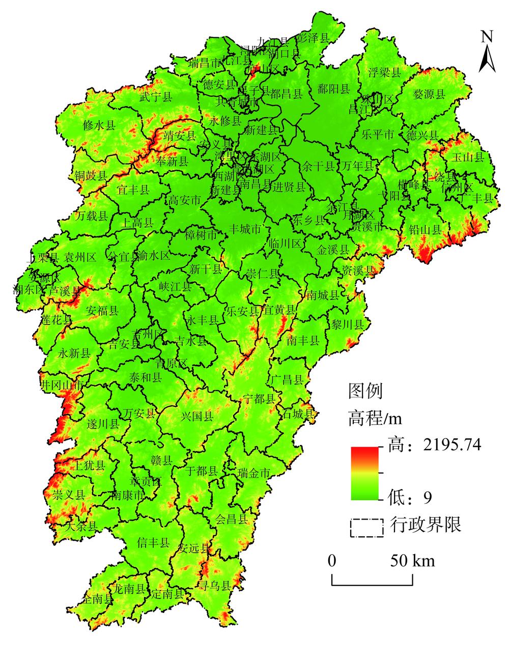
    Fig. 1. Schematic diagram of terrain and extent of the study area
    Distribution of "three lines" conflict index of Jiangxi province
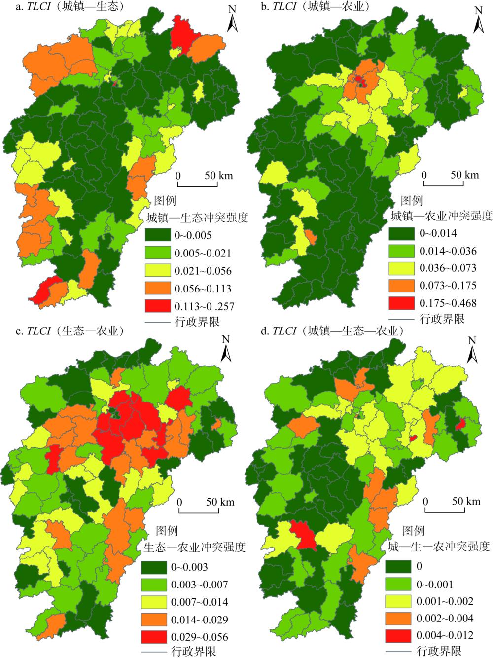
    Fig. 2. Distribution of "three lines" conflict index of Jiangxi province
    Distribution of the Z(Gi*) values of "three lines" conflict index of Jiangxi province
    Fig. 3. Distribution of the Z(Gi*) values of "three lines" conflict index of Jiangxi province
    The spatial differentiation of town-ecology conflict intensity impact factors
    Fig. 4. The spatial differentiation of town-ecology conflict intensity impact factors
    The spatial differentiation of town-agriculture conflict intensity impact factors
    Fig. 5. The spatial differentiation of town-agriculture conflict intensity impact factors
    The spatial differentiation of ecology-agriculture conflict intensity impact factors
    Fig. 6. The spatial differentiation of ecology-agriculture conflict intensity impact factors
    The spatial differentiation of town-ecology-agriculture conflict intensity impact factors
    Fig. 7. The spatial differentiation of town-ecology-agriculture conflict intensity impact factors
    一级指标二级指标单位数据来源
    自然环境条件地形位指数(x130 m×30 m DEM(http://www.gscloud.cn/)
    植被覆盖度(x2遥感影像波段(http://www.gscloud.cn/)
    居民点密度(x3江西省土地利用变更调查成果(2015年)
    社会经济状况人口(x4万人各地级市统计年鉴及统计公报(2017年)
    人均GDP(x5元/人各地级市统计年鉴及统计公报(2017年)
    城镇化率(x6%各地级市统计年鉴及统计公报(2017年)
    固定资产投资强度(x7万元各地级市统计年鉴及统计公报(2017年)
    地理区位特征距河流距离(x8km电子地图数据集(http://www.tianditu.gov.cn/)
    距主要公路距离(x9km电子地图数据集(http://www.tianditu.gov.cn/)
    土地利用特征土地利用丰富度(x10%江西省土地利用变更调查成果(2015年)
    优质耕地占总耕地面积比(x11%耕地质量等别年度更新评价分析报告(2017年)
    建设用地适宜区占总面积比(x12%江西省国土空间开发适宜性评价专题数据(2017年)
    生态功能重要区占总面积比(x13%江西省国土空间开发适宜性评价专题数据(2017年)
    规划因素新增建设用地指标(x14hm2江西省土地利用总体规划(2006—2020年)文本
    Table 1. Impact factor variables and description
    冲突类型强度指数x1x2x3x4x5x6x7
    城镇—生态0.251*0.211*-0.288**0.214*
    城镇—农业-0.346**-0.378**0.521**0.365**0.432**0.464**
    生态—农业-0.404**0.331**
    城镇—生态—农业0.252*
    冲突类型强度指数x8x9x10x11x12x13x14
    城镇—生态0.197*-0.380**0.210*-0.231*
    城镇—农业-0.279**-0.254*0.278**0.706**-0.220*0.249*
    生态—农业-0.287**0.260**0.243*
    城镇—生态—农业-0.223*
    Table 2. Results of the intensity correlation analysis of "three lines" conflict
    冲突类型强度指数城镇—生态城镇—农业生态—农业城镇—生态—农业
    AICcR2adjAICcR2adjAICcR2adjAICcR2adj
    OLS模型-114.2280.333-208.8300.530-44.7130.174-73.3620.123
    GWR模型-118.2170.389-212.2260.557-49.7070.194-101.6480.362
    GWR模型对模拟精度指标的提高-3.9890.056-3.3960.027-4.9940.020-28.8270.239
    Table 3. Comparison of GWR and OLS model parameter estimation for different types of conflict strength
    Dan YI, Xiao-min ZHAO, Xi GUO, Yi HAN, Ye-feng JIANG, Xia-hua LAI, Xin-yi HUANG. Study on the spatial characteristics and intensity factors of "three-line conflict" in Jiangxi province[J]. Journal of Natural Resources, 2020, 35(10): 2428
    Download Citation