[1] 宫宁, 牛振国, 齐伟, 等. 中国湿地变化的驱动力分析[J]. 遥感学报, 2016,20(2):172-183. [ GongN, NiuZ G, QiW, et al. Driving forces of wetland change in China[J]. Journal of Remote Sensing, 2016,20(2):172-183. ] [ Gong N, Niu Z G, Qi W, et al. Driving forces of wetland change in China[J]. Journal of Remote Sensing, 2016,20(2):172-183. ]
[2] 左平, 李云, 赵书河, 等. 1976年以来江苏盐城滨海湿地景观变化及驱动力分析[J]. 海洋学报(中文版), 2012,34(1):101-108. [ ZuoP, LiY, ZhaoS H, et al. Landscape changes of Jiangsu Yancheng coastal wetlands and their driving forces since 1976[J]. Acta Oceanologica Sinica, 2012,34(1):101-108. ] [ Zuo P, Li Y, Zhao S H, et al. Landscape changes of Jiangsu Yancheng coastal wetlands and their driving forces since 1976[J]. Acta Oceanologica Sinica, 2012,34(1):101-108. ]
[3] 王成军, 毛政元, 徐伟铭, 等. 超像素与主动学习相结合的遥感影像变化检测方法[J]. 地球信息科学学报, 2018,20(2):235-245. [ WangC J, MaoZ Y, XuW M, et al. Change detection approach for high resolution remotely sensed images based on superpixel and active learning[J]. Journal of Geo-information Science, 2018,20(2):235-245. ] [ Wang C J, Mao Z Y, Xu W M, et al. Change detection approach for high resolution remotely sensed images based on superpixel and active learning[J]. Journal of Geo-information Science, 2018,20(2):235-245. ]
[4] 李杨, 江南, 侍昊, 等. Landsat-8影像的LDA模型变化检测[J]. 地球信息科学学报, 2015,17(3):353-360. [ LiY, JiangN, ShiH, et al. Change detection and analysis of Landsat-8 image based on LDA model[J]. Journal of Geo-information Science, 2015,17(3):353-360. ] [ Li Y, Jiang N, Shi H, et al. Change detection and analysis of Landsat-8 image based on LDA model[J]. Journal of Geo-information Science, 2015,17(3):353-360. ]
[5] 张志强, 张新长, 辛秦川, 等. 结合像元级和目标级的高分辨率遥感影像建筑物变化检测[J]. 测绘学报, 2018,47(1):102-112. [ ZhangZ Q, ZhangX C, XinQ C, et al. Combining the pixel-based and object-based methods for building change detection using high-resolution remote sensing images[J]. Acta Geodaetica et Cartographica Sinica, 2018,47(1):102-112. ] [ Zhang Z Q, Zhang X C, Xin Q C, et al. Combining the pixel-based and object-based methods for building change detection using high-resolution remote sensing images[J]. Acta Geodaetica et Cartographica Sinica, 2018,47(1):102-112. ]
[6] CaoG, LiY P, LiuY Z et al. Automatic change detection in high-resolution remote-sensing images by means of level set evolution and support vector machine classification[J]. International Journal of Remote Sensing, 35, 6255-6270(2014).
[7] XiaoP F, ZhangX L, WangD G et al. Change detection of built-up land: A framework of combining pixel-based detection and object-based recognition[J]. ISPRS Journal of Photogrammetry and Remote Sensing, 119, 402-414(2016).
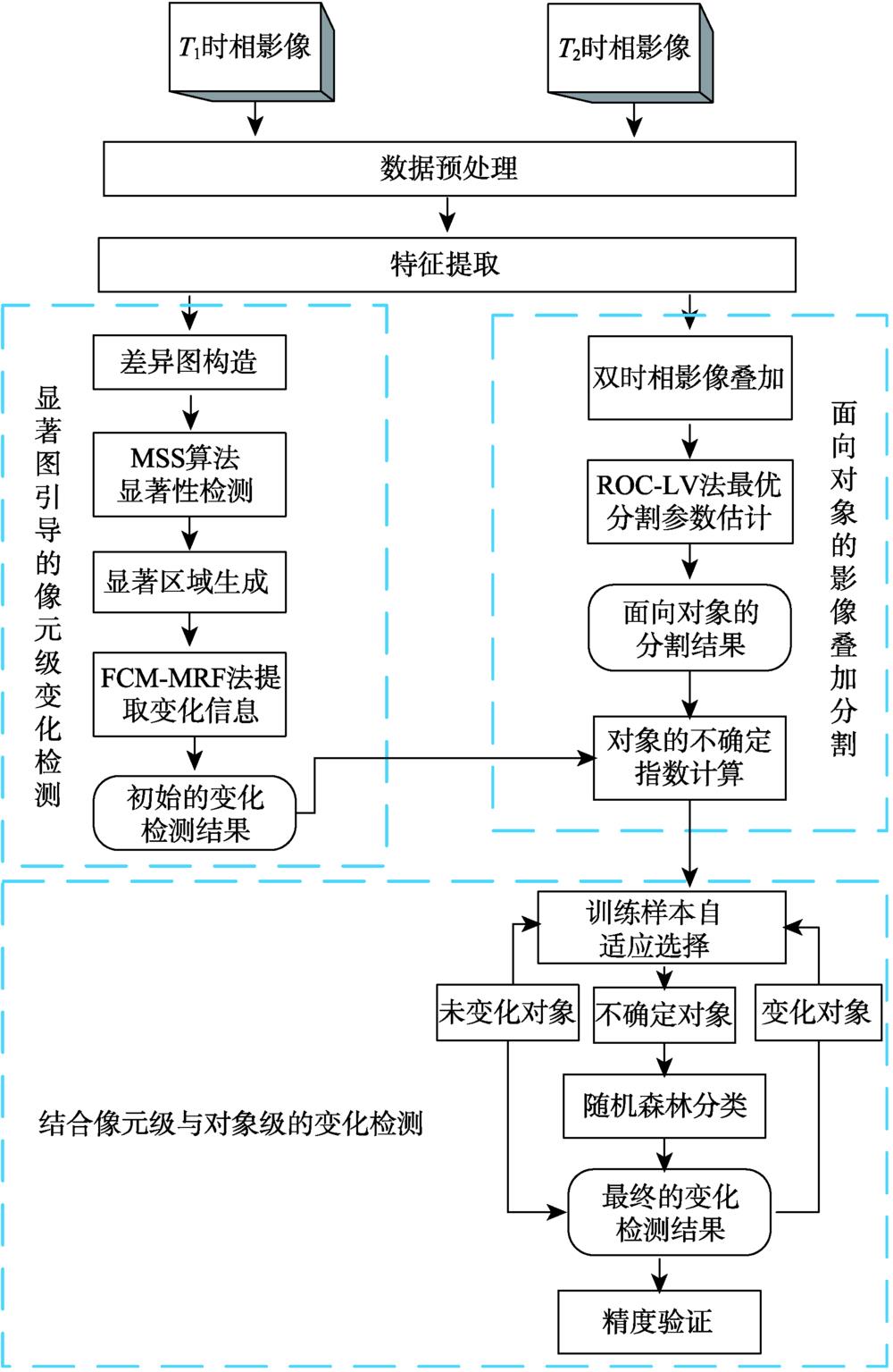
[8] 冯文卿, 眭海刚, 涂继辉, 等. 联合像元级和对象级分析的遥感影像变化检测[J]. 测绘学报, 2017,46(9):1147-1155,1164. [ FengW Q, SuiH G, TuJ H, et al. Remote sensing image change detection based on the combination of pixel-level and object-level analysis[J]. Acta Geodaetica et Cartographica Sinica, 2017,46(9):1147-1155,1164. ] [ Feng W Q, Sui H G, Tu J H, et al. Remote sensing image change detection based on the combination of pixel-level and object-level analysis[J]. Acta Geodaetica et Cartographica Sinica, 2017,46(9):1147-1155,1164. ]
[9] HuangX, ZhangL P, ZhuT T. Building change detection from multitemporal high-resolution remotely sensed images based on a morphological building index[J]. IEEE Journal of Selected Topics in Applied Earth Observations and Remote Sensing, 7, 105-115(2014).
[10] ZhengY G, JiaoL C, LiuH Y et al. Unsupervised saliency-guided SAR image change detection[J]. Pattern Recognition, 61, 309-326(2017).
[11] FengW Q, SuiH G, ChenX. Saliency-guided change detection of remotely sensed images using random forest[C]. The International Archives of the Photogrammetry, Remote Sensing and Spatial Information Sciences, 3, 341-348(2018).
[12] 何鹏飞. 基于不确定性分析的遥感影像变化检测方法研究[D]. 徐州:中国矿业大学, 2017. [ HeP F. Research on the remotely sensed images change detection methods based on uncertainty analysis[D]. Xuzhou: China University of Mining and Technology, 2017. ] [ He P F. Research on the remotely sensed images change detection methods based on uncertainty analysis[D]. Xuzhou: China University of Mining and Technology, 2017. ]
[13] PeronaP, HarelJ, KochC. Graph-based visual saliency[C]. Neural Information Processing Systems, 545-552(2006).
[14] GofermanS, ZelnikmanorL, TalA. Context-Aware saliency detection[J]. IEEE Transactions on Pattern Analysis and Machine Intelligence, 34, 1915-1926(2012).
[15] SusstrunkS, AchantaR. Saliency detection using maximum symmetric surround[C]. International Conference on Image Processing, 2653-2656(2010).
[16] 郝明. 基于空间信息准确性增强的遥感影像变化检测方法研究[D]. 徐州:中国矿业大学, 2015. [ HaoM. Change detection methods for remotely sensed images based on enhanced spatial information[D]. Xuzhou: China University of Mining and Technology, 2015. ] [ Hao M. Change detection methods for remotely sensed images based on enhanced spatial information[D]. Xuzhou: China University of Mining and Technology, 2015. ]
[17] DragutL, TiedeD, LevickS R. ESP: A tool to estimate scale parameter for multiresolution image segmentation of remotely sensed data[J]. International Journal of Geographical Information Science, 24, 859-871(2010).
[19] 郝敬锋, 刘红玉, 李玉凤, 等. 基于转移矩阵模型的江苏海滨湿地资源时空演变特征及驱动机制分析[J]. 自然资源学报, 2010,25(11):1918-1929. [ HaoJ F, LiuH Y, LiY F, et al. Spatio-temporal variation and driving forces of the coastal wetland resources based on the transition matrix in Jiangsu Province[J]. Journal of Natural Resources, 2010,25(11):1918-1929. ] [ Hao J F, Liu H Y, Li Y F, et al. Spatio-temporal variation and driving forces of the coastal wetland resources based on the transition matrix in Jiangsu Province[J]. Journal of Natural Resources, 2010,25(11):1918-1929. ]
[21] 冷英, 李宁. 一种改进的变化检测方法及其在洪水监测中的应用[J]. 雷达学报, 2017,6(2):204-212. [ LengY, LiN. Improved change detection method for flood monitoring[J]. Journal of Radars, 2017,6(2):204-212. ] [ Leng Y, Li N. Improved change detection method for flood monitoring[J]. Journal of Radars, 2017,6(2):204-212. ]