• Journal of Natural Resources
  • Vol. 35, Issue 1, 141 (2020)
Bo HAN1, Xiao-bin JIN1、2、3、*, Xiao-min XIANG1, Qing-li ZHAO4, Jin-huang LIN1, Chang-qiao HONG1, Zhi-feng JIN5, Jing HU6, and Yin-kang ZHOU1、2、3
Author Affiliations
  • 1School of Geographic and Oceanographic Sciences, Nanjing University, Nanjing 210023, China
  • 2Key Laboratory of Coastal Zone Exploitation and Protection, Ministry of Natural Resources, Nanjing 210023, China
  • 3Jiangsu Land Development and Consolidation Technology Engineering Center, Nanjing 210023, China
  • 4Land Consolidation and Rehabilitation Center, Ministry of Natural Resources, Beijing 100035, China
  • 5Land and Resources Research Center (Think Tank) of Jiangsu Province, Nanjing 210023, China
  • 6Chongqing Rural Land Consolidation Center, Chongqing 401121, China
  • show less
    DOI: 10.31497/zrzyxb.20200113 Cite this Article
    Bo HAN, Xiao-bin JIN, Xiao-min XIANG, Qing-li ZHAO, Jin-huang LIN, Chang-qiao HONG, Zhi-feng JIN, Jing HU, Yin-kang ZHOU. Exploration of ecological restoration pattern and countermeasure along the Yangtze River in Jiangsu province based on the "element-landscape-system" framework[J]. Journal of Natural Resources, 2020, 35(1): 141 Copy Citation Text show less
    Location of the study area
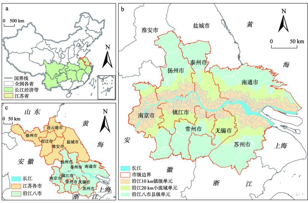
    Fig. 1. Location of the study area
    Framework of ecological restoration connotation
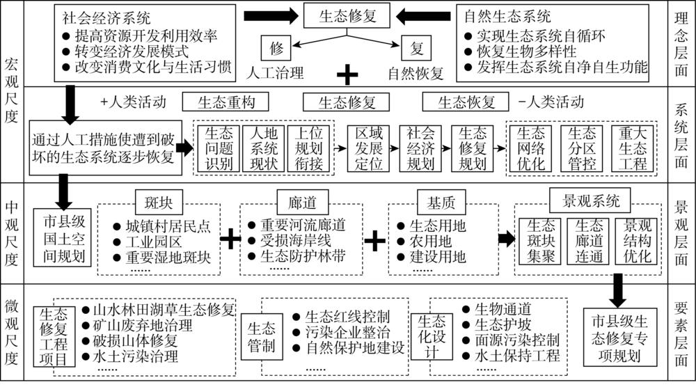
    Fig. 2. Framework of ecological restoration connotation
    Map showing element level results
    Fig. 3. Map showing element level results
    Landscape level results
    Fig. 4. Landscape level results
    Map showing system level results
    Fig. 5. Map showing system level results
    Overall structure of ecological restoration
    Fig. 6. Overall structure of ecological restoration
    评价对象要素景观系统
    压力土地利用变化压力指数A1景观压力指数B1人口增长率C1
    GDP增长率C2
    工业产值增长率C3
    状态工业用地面积比A2生态景观连通度B2生境质量C4
    水面率A3生态景观分割度B3固碳量C5
    水田面积比A4生态景观聚集度B4水源涵养量C6
    土壤重金属污染A5
    植被覆盖度A6
    响应禁止开发区面积比A7规划生态景观连通度B5国家级生态保护红线面积比C7
    基本农田保护区面积比A8规划生态景观分割度B6主体功能区类型C8
    风景旅游用地区面积比A9规划生态景观聚集度B7
    林草业用途区面积比A10
    综合指标要素层生态修复潜力A11景观层生态修复潜力B8/
    Table 1. Ecological restoration evaluation index system under "element-landscape-system" framework
    权重矩阵水田其他农用地生态用地建设用地
    水田00.08-0.10.24
    其他农用地-0.080-0.120.16
    生态用地0.10.1200.3
    建设用地-0.24-0.16-0.30
    Table 2. Weight matrix of land use type transfer pressure
    数据类型来源数据时间空间分辨率
    土地利用数据江苏省沿江八市土地利用变更调查数据库2010年、2017年1∶10000
    工业用地矢量数据江苏省工业用地调查数据库2016年1∶10000
    土地利用规划数据江苏省沿江八市乡级土地利用总体规划数据库2020年1∶10000
    社会经济数据沿江八市统计年鉴2010年、2017年县级
    EVI (MOD09A1)https://search.earthdata.nasa.gov2018年500 m
    土壤重金属含量数据江苏省浅层土壤调查数据2017年2 km
    生态保护红线数据《江苏省国家级生态保护红线规划》2018年1∶100000
    主体功能区数据《江苏省主体功能区规划》2014年县级
    Table 3. Data source and description
    聚类
    分区
    县级
    单元
    数/个
    国土
    面积
    /km2
    平均人口
    增长率/%
    平均
    GDP
    增长率/%
    平均
    工业产值增长率/%
    水源
    涵养量
    /108 t
    固碳量
    /106 t
    平均
    生境
    质量
    平均生态
    红线面积
    占比/%
    主体
    功能区
    类型
    聚类Ⅰ3112154.6619.05117.0836.901289.393212.700.1745.29优化开发区
    聚类Ⅱ1010258.233.80124.0772.61795.831832.410.2828.59农产品主产区优化开发区
    聚类Ⅲ1715660.153.00133.0691.951122.603589.460.1572.86重点开发区
    聚类Ⅳ33192.0825.1163.9739.83106.02188.360.61854.17优化开发区
    聚类Ⅴ59754.22-1.03133.90111.62260.351140.360.2028.11农产品主产区
    Table 4. Statistical table of cluster indexes
    Bo HAN, Xiao-bin JIN, Xiao-min XIANG, Qing-li ZHAO, Jin-huang LIN, Chang-qiao HONG, Zhi-feng JIN, Jing HU, Yin-kang ZHOU. Exploration of ecological restoration pattern and countermeasure along the Yangtze River in Jiangsu province based on the "element-landscape-system" framework[J]. Journal of Natural Resources, 2020, 35(1): 141
    Download Citation