• Acta Geographica Sinica
  • Vol. 75, Issue 9, 1983 (2020)
Weishi YANG1, Erfu DAI2, Du ZHENG3、4, Yuxiang DONG1, Le YIN3、4, Liang MA2、4, Junxiong WANG5, Lihu PAN6, and Shipeng QIN6
Author Affiliations
  • 1School of Geography and Planning, Sun Yat-Sen University, Guangzhou 510275, China
  • 2Lhasa Plateau Ecosystem Research Station, Key Laboratory of Ecosystem Network Observation and Modeling, Institute of Geographic Sciences and Natural Resources Research, CAS, Beijing 100101, China
  • 3Key Laboratory of Land Surface Pattern and Simulation, Institute of Geographic Sciences and Natural Resources Research, CAS, Beijing 100101, China
  • 4University of Chinese Academy of Sciences, Beijing 100049, China
  • 5School of Geography and Tourism, Shaanxi Normal University, Xi'an 710119, China
  • 6College of Computer Science and Technology, Taiyuan University of Science and Technology, Taiyuan 030024, China
  • show less
    DOI: 10.11821/dlxb202009012 Cite this Article
    Weishi YANG, Erfu DAI, Du ZHENG, Yuxiang DONG, Le YIN, Liang MA, Junxiong WANG, Lihu PAN, Shipeng QIN. Spatial simulation of "Grain to Green Program" implementation in a typical region based on agent-based model[J]. Acta Geographica Sinica, 2020, 75(9): 1983 Copy Citation Text show less
    Framework of regional spatial simulation of "Grain to Green Program" implementation
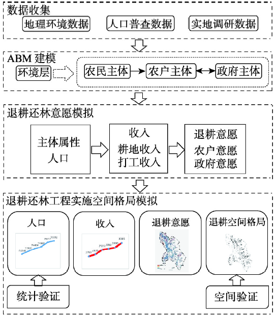
    Fig. 1. Framework of regional spatial simulation of "Grain to Green Program" implementation
    Initialization of farmers and farmer household agents for the regional spatial simulation of "Grain to Green Program"
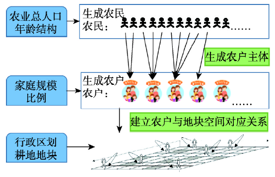
    Fig. 2. Initialization of farmers and farmer household agents for the regional spatial simulation of "Grain to Green Program"
    Process of the regional spatial simulation of "Grain to Green Program" implementation
    Fig. 3. Process of the regional spatial simulation of "Grain to Green Program" implementation
    Location of Tongdu Town
    Fig. 4. Location of Tongdu Town
    Spatialized data for the spatial simulation of "Grain to Green Program" implementation in Tongdu Town
    Fig. 5. Spatialized data for the spatial simulation of "Grain to Green Program" implementation in Tongdu Town
    Farming population in Tongdu Town from 2010 to 2015
    Fig. 6. Farming population in Tongdu Town from 2010 to 2015
    Demographic features of different income ranges in Tongdu Town from 2010 to 2015
    Fig. 7. Demographic features of different income ranges in Tongdu Town from 2010 to 2015
    Spatial distribution of annual income of farmer households in Tongdu Town from 2010 to 2015
    Fig. 8. Spatial distribution of annual income of farmer households in Tongdu Town from 2010 to 2015
    Simulation of willingness to "Grain to Green Program" in Tongdu Town in 2010
    Fig. 9. Simulation of willingness to "Grain to Green Program" in Tongdu Town in 2010
    Land use change in Tongdu Town from 2010 to 2015
    Fig. 10. Land use change in Tongdu Town from 2010 to 2015
    Relationship of "Grain to Green Program" with the distribution of cropland and annual income of farmer households
    Fig. 11. Relationship of "Grain to Green Program" with the distribution of cropland and annual income of farmer households
    Validation of models
    Fig. 12. Validation of models
    数据类别数据项数据来源
    主体属性数据农户家庭规模比例人口普查数据、实地调研
    年龄结构
    生育率(分年龄段)
    死率亡(分年龄段)
    农业人口总量
    打工收入(分年龄段)
    耕地收入数据同海拔最高肥力耕地最大年收入(IncomeAgri·Max)实地调研
    耕地坡度系数(αSD)
    耕地肥力等级系数(αSQ)
    耕地年交通费用(CostTra)
    单位耕地最低需求劳动力(LaborMin)
    地理环境数据海拔中国科学院资源环境科学数据中心、遥感影像处理、部门调研等
    坡度等级
    土壤肥力等级
    土地利用类型
    离公路网距离
    离城市中心距离
    行政区划
    退耕数据退耕还林工程面积指标部门调研
    Table 1. Spatial simulated data list for the regional spatial simulation of "Grain to Green Program"
    Weishi YANG, Erfu DAI, Du ZHENG, Yuxiang DONG, Le YIN, Liang MA, Junxiong WANG, Lihu PAN, Shipeng QIN. Spatial simulation of "Grain to Green Program" implementation in a typical region based on agent-based model[J]. Acta Geographica Sinica, 2020, 75(9): 1983
    Download Citation