• Journal of Resources and Ecology
  • Vol. 11, Issue 2, 171 (2020)
W Pearson MATTHEW
Author Affiliations
  • [in Chinese]
  • show less
    DOI: 10.5814/j.issn.1674-764x.2020.02.005 Cite this Article
    W Pearson MATTHEW. A Case Study of Allocasuarina robusta Recovery Using History and Biogeography to Identify Future Priorities[J]. Journal of Resources and Ecology, 2020, 11(2): 171 Copy Citation Text show less

    Abstract

    Identifying the cause of a threatened species can aid in how best to formulate recovery actions. Recovery can be based on broad concepts and may not reflect a specific community or species requirements. Urban sprawl and intensification of land are known as threatening processes. How a threatening process interacts with a threatened species can aid in the recovery efforts. In South Australia, the species Allocasuarina robusta provides an opportunity to understand how past land usage may direct recovery efforts. Information on past land usage can involve identifying and using data from multiple repositories. The investigation focused on the relationship between changes in land use and herbarium data to understand a relationship between a common and threatened species. As a species evolves and adapts, the conservation practices used, including the methods used for identifying future actions, needs to be reflective of a changing environment. A changing environment can have consequences to biodiversity, creating several issues for a land manager. Traditional species recovery techniques can slow the threatening process down. Sometimes these threats may be visible like grazing from fauna (native and introduced). The threat to Allocasuarina robusta is a change in land use originating from anthropogenic activities. Supplementary planting with tube stock is a well-grounded practice, but the implications from this practice may need further investigation. Natural regeneration is crucial for long term population survival, but in Allocasuarina robusta, this is not occurring. The Allocasuarina robusta investigation aims to explore the relationships between herbarium data and land-use histories to guide future recovery efforts.

    1 Introduction

    Lindenmayer (2019) synopsis, challenges our concepts towards the size of conservation areas and what size means towards conservation. The synopsis adds to the debate of single large or serval small areas for conservation (Lindenmayer, 2019). Lindenmayer (2019) discusses the need to think smaller as in single isolated species. The difficulty of turning the concepts and ideas of Lindenmayer (2019) into good land management practices as described by Bardsley et al. (2015) is the lack of oversight within government agencies which can effectively degrade biodiversity.

    Pilgrim et al. (2004) suggest viable populations of trees, as opposed to shrubs, require an extensive range due to pollination requirements. The type of pollination which Pilgrim et al. (2004) identified for trees was predominantly wind. Understanding population dynamics is seen as crucial to allow the conservation category to be validated (Salzer and Salafsky, 2006). The conservation categories can dictate the practices to be used, which can be an ongoing process (Heywooda and Iriondo, 2003; Salzer and Salafsky, 2006).

    Species classification within a conservation category follows a continuum from critically endangered to least concern. Deciding where to place a species along this continuum is sometimes based on a species spatial distribution (Salzer and Salafsky, 2006; Violle et al., 2017). These constructs can appear theoretical but, can aid the government in prioritising programs to fund or to decide where to place funding to protect the maximum number of species (Master, 1991). A key aspect to the conservation of threatened species is funding, without funding conservation will not occur (Master, 1991). The difficulty with funding is without having a timeline or appraisal systems incorporated into the recovery efforts; incorrect conservation categories can be assigned (Elzinga et al., 1998). With the collection, storage and integration of data, the need to undertake regular field surveys to validate information is still required (Pressey and Nicholls, 1989). The collection of information which relates to a species can result in the production of a recovery plan which occurred for Allocasuarina robusta (Quarmby, 2011). The investigation aims to validate the work of Quarmby (2011) but more importantly, to investigate the relationships between herbarium data and land-use histories for guiding future recovery efforts.

    2 The Study species - Allocasuarina robusta

    Allocasuarina is a member of the Casuarinaceae family, which has two genera found in South Australia; the second genera is Casuarina (Jessop et al., 1986; Wilson and Johnson, 1989). Casuarinaceae is considered as an early derivative of the angiosperms (Dilcher et al., 1990). While rare species of Allocasurarina exist, much of the research on the genus has focused on populations at a community level. Understanding a species either in its entirety or filling knowledge gaps is critical to the management of endangered species (Willson and Bignall, 2009). A taxonomic revision of Allocasurarina led to some conjecture over the taxonomic treatment for Allocasurarina robusta considered to be possibly a subspecies of Allocasurarina pusilla (Johnson, 1982). However, Jessop et al. (1986) considered the species to have a greater resemblance to Allocasurarina paradoxa in the South East of South Australia and Victoria. The last revision of the family Casuarinaceae in 1988, created the split within Casuarina, enabling recognition of Allocasuarina as a distinct genus (Dilcher et al., 1990).

    Pollination in members of Casuarinaceae occurs by the wind; the bracteoles develop into a fruit that contains a single winged samara seed (Swamy, 1948). The female inflorescence develops a woody cylindrical infructescence consisting of whorls of tightly appressed hairs of enlarged floral bracteoles (Pannell and Myerscough, 1993). Growth of the floral bracteoles indicates the formation of aggregate fruit in Allocasuarina. The aggregate fruit is initially hairy but develops two woody valves with the seed filling the cavity (Swamy, 1948). A distinguishing characteristic for identifying Allocasurarina robusta described by Jessop et al. (1986) from specimens collected is the reduced or absent petiole to the infructescence.

    Allocasuarina robusta distribution is confined to the Fleurieu Peninsula and Southern Mount Lofty Ranges in South Australia, covering an area of 172 km2 (Quarmby, 2011). The species consists of several smaller fragmented populations. Populations on the Fleurieu Peninsula is limited to a few localities being Yundi, Mount Compass, and Hindmarsh Tiers (Fig. 1). Allocasuarina robusta had a much larger distribution on the Fleurieu Peninsula and extended further northwards into the southern Mount Lofty Ranges (Quarmby, 2011). Quarmby (2011) raised the possibility that Allocasuarina robusta may exist undetected on private land.

    The conservation status of Allocasuarina robusta under Commonwealth legislation (Environment Protection and Biodiversity Conservation Act, 1999) and the South Australian state legislation (National Parks and Wildlife Act, 1972) is as a threatened species. The species is listed as threatened due to restricted distribution and faced with a variety of threatening processes (Quarmby, 2011). The threatening processes are mostly historical practices including land clearing, swamp drainage and grazing, some of which are continuing today (Quarmby, 2011).

    3 Allocasuarina robusta Botanical data

    An Allocasuarina robusta population census occurred (Quarmby, 2011) and with the species confirmed at a genetic level (Ottewell et al., 2016). Postulation on other Allocasuarina in terms of their correct conservation category is mere conjecture. Not all species of Allocasuarina are under threat. Some Allocasuarina could fall into a category known as pseudo-commonness (Gaston, 2010). The Southern Mount Lofty Ranges may be reflective of pseudo-commonness due to the rapid change in land use. Altered natural processes in the Southern Mount Lofty Ranges may have resulted in reducing floristic species diversity (Gaston, 2010; Guerin 2017). Field naturalists have been enthusiastically collecting specimens over time (Paton and Crompton, 2013). From specimen data, and associated species found in the range of Allocasuarina robusta is Allocasuarina pusilla (Fig. 1) which has several nearby populations and is considered a common species.

    One of the processes used for defining flora for conservation is using specimens collected and then using the specimens to generate a model of what makes a species rare (Pilgrim et al., 2004). The point made by Pilgrim et al. (2004) is a species morphology used to define rarity. With the advent of phylogenetics to analysis a species traits, the development has meant an evolutionary projection towards rarity can be determined (Pilgrim et al., 2004). Pilgrim et al. (2004) investigation showed that rare species had traits directly or indirectly related to human impacts. The human impact was related to environmental factors as opposed to genetic factors. Environmental factors included land-use changes, resilience on a specific habitat and the species taxonomy through over splitting (Pilgrim et al., 2004).

    Map of Allocasuarina robusta and Allocasuarina pusilla distribution on the Fleurieu Peninsula Note: Pusi = Allocasuarina pusilla; Robu = Allocasuarina robusta.

    Figure 1.Map of Allocasuarina robusta and Allocasuarina pusilla distribution on the Fleurieu Peninsula Note: Pusi = Allocasuarina pusilla; Robu = Allocasuarina robusta.

    Pilgrim et al. (2004) were not alone in identifying these environmental factors. Corlett (2016) defined these impacts categories with greater explicitly compared to the board encapsulating categories of Pilgrim et al. (2004).

    Understanding the environmental factors impacting on flora may aid conservation practices, but it might not conserve a specific species (Corlett, 2016). The greater the threat, the higher the classification for a species. A higher classification (i.e. critically endangered species) does not translate into devoting greater funding towards ensuring a species long terms survival (Given and Norton, 1993). Species like Allocasuarina robusta a threatened species defined in state and federal legislation does not automatically receive funding towards recovery efforts (Quarmby, 2011). Some reviews have identified that threatened fauna receives significantly more funding compared to threatened flora (Corlett, 2016). The reasoning behind the attention provided to fauna; is fauna can generate popular appeal compared to flora (Corlett, 2016).

    Given and Norton (1993) concluded that a species must be one which has widespread appeal with the public. How this process identifies which species to protect or reinforce Given and Norton (1993) questioned. The natural extension of Given and Norton (1993) is the development of an action plan describing the priorities for conserving a species. These schemes work well within government, although they are considered flawed through thinking of each species on a linear continuum (Given and Norton, 1993). Groups of unrelated species can congregate at points along the continuum providing misinformation (Given and Norton, 1993). Pilgrim et al. (2004) explained that many of the rare and endangered species have similar breeding systems or habitats. Given and Norton (1993) considers these linear continuums as providing a false perception to threatened and rare species. Floristic conservation for population survival requires population size and connectedness as a fundamental requirement (Heywooda and Iriondo, 2003).

    Population modelling needs to use a suitably sized population to enable a species to be self-sustaining. Quarmby (2011) validated populations of Allocasuarina robusta from those on public land through ground-truthing, the statement had the proviso for private land having the potential for new populations of Allocasuarina robusta. Translating Quarmby (2011) observations and postulations for the sparsely distributed Allocasuarina robusta into distribution modelling may not produce accurate results as the data could have an inherent sampling bias (Williams et al., 2009). The species distribution model for Allocasuarina robusta would not be viable due to the limitations in sample size, distribution and integrity of the previous species data (Williams et al., 2009). Validating the populations on public land could be interpreted as sampling bias (Williams et al., 2009). Modelling small species population may not have sufficient data to determine if a population are self-sustaining (Williams et al., 2009). The lack of data for modelling provides a challenge towards knowing what type of data would be useful for understanding a sparsely distributed species.

    4 Supportive or complementary data sources

    Without this data, the next best option is to use historical land use accounts (Swetnam et al., 1999). In Allocasuarina robusta, distribution the land-use histories describe a dramatic change to the landscape over the last 180 years. Bickford et al. (2008) describe from 1839-1850 agricultural practices were little more than subsistence farming owing to the difficulties in transporting produce to Adelaide. Agriculture began to intensify with the clearing of land for forestry, fencing and improved pasture from the 1850s onwards (Bickford et al., 2008). From the intensification improved pasture varieties were required as stock grazed the more palatable vegetation, leaving non-palatable vegetation to become dominant. Allocasuarina, as described by Bickford et al. (2008), was grazed upon by livestock. Cropping for wheat began on cleared and easily traversed land with agricultural implements in the 1850s, which coincided with improved trade routes (Bickford and Mackey, 2004).

    By the 1870’s cropping in the flat plateau areas, had concluded which incorporates the Hindmarsh Tiers area (Bickford and Mackey, 2004). In the 1870s, soil fertility was diminishing, which required new agricultural approaches or enterprises to be established (Bickford and Mackey, 2004). It was not until the 1900s that agriculture made a significant change through the application of fertilisers to bolster productivity on infertile land (Bickford and Mackey, 2004; Reuter, 2012). Through the latter part of the 1800s through to the mid-1900s land clearing increased and the harvesting of native vegetation for forestry, tannins or gum increased, allowing for new agriculture pursuits to occur (Bickford et al. 2008; Reuter, 2012). The overlooked role of naturalists is not documented thoroughly at the time of increased agricultural activity in the early part of the 1900s (Bickford et al., 2008). Two of the most prominent naturalists at the time were Sir John Burton Cleland (Cleland) and John McConnell Black (Black), who collected widely throughout the Fleurieu Peninsula (Paton and Crompton, 2013).

    By the 1920s, extensive clearing for agriculture occurred around Victor Harbor (Paton and Crompton, 2013). From early records of naturalists like Cleland and Black who identified the land surrounding Victor Harbour had few remaining remnants in the paddocks (confined to useable sections of land) or along roadways (Paton and Crompton, 2013). The waterways which ran into Victor Harbour being the Inman and Hindmarsh Rivers were a means to drain swamps and thus alter vegetation communities (Fusco et al. 2015). In particular, Allocasuarina pusilla noted to grow in association with Allocasuarina striata and Allocasuarina muelleriana along the creek line at Back Valley (Paton and Crompton, 2013). Paton and Crompton (2013) surmise that the loss of vegetation communities resulted in a loss of species. Examining the current distribution and morphology of similar species found in Allocasuarina robusta range can aid in helping the species to recover. Herbarium data can provide a species range and distribution, but more importantly, it can provide insight into the frequency in which collections have occurred (Rivers et al., 2011). Herbarium data, when coupled with the recovery plan written by Quarmby (2011), can validate a species distribution map.

    Herbarium data does not provide insight into the type of land management practices for facilitating a species recovery. In the case of Allocasuarina robusta, the resilience of the species and how it reacts to fire, introduced flora or human impacts, are still relatively unknown (Elzinga et al., 1998; Quarmby, 2011). A threat assessment would seem logical, as it may unmask species-specific threats, or reveal new threats which need resolution. Displacement of native flora can occur through introduced flora (McIntyre and Lavorel, 1994). The impact of introduced flora on native vegetation as described by McIntyre and Lavorel (1994) can range from competition to altering the physical environment or changing ecosystem processes. Landscape processes altered by humans are reliant on how well historical documentation has occurred in the past. To understand aspect like fire regimes before European colonisation may require using other sources of information.

    The loss of vegetation via European colonisation on the Fleurieu Peninsula is estimated to be as high as 42% (Harding, 2005; Fusco et al., 2015). Only 13% of the remaining vegetation is intact (Crossman et al., 2011). The region floristic importance often underestimated due to increased urbanisation/introduced species according to Crossman et al. (2011), and Bardsley and Sweeney (2010) as 50% of the state native floristic species occur in this region. European arrival into South Australia has had a substantial impact on the vegetation as acknowledged by Bardsley et al. (2015), Bickford et al. (2008), Fusco et al. (2015) and Crossman et al. (2011). What is not acknowledge as frequently is the Aboriginal presence on the landscape which involved fire stick farming (Bickford and Gell, 2005). Bardsley et al. (2015) describe the work of an early colony artist where the vegetation becomes increasingly denser over time with the withdrawal and changes to fire regimes. Bardsley, Weber et al. (2015) inferred changed fire regimes occurred when Europeans arrived. Understanding fire regimes before European arrival can only occur through investigating Holocene sediments (Bickford and Gell, 2005).

    Paleontological records of Holocene sediments show Allocasuarina verticillata was a dominant species of the Fleurieu Peninsula (Bickford and Gell, 2005). The change in vegetation further altered the fire regimes, which increased the charcoal/ash in the soil sediments at the time of the Holocene (Bickford and Gell, 2005). The consequence of fire as Bickford and Gell (2005) theorised was vegetation assemblages would change to reflect the new fire regimes. The dominance in Allocasuarina is related to a decrease in pollen produced by Eucalyptus species (Bickford and Gell, 2005). Allocasuarina robusta pollen is challenging to identify from that of other Allocasuarina pollen due to the smallness of the pollen grains. Except for Allocasuarina verticillata, which has larger, more distinguishable pollen grains (Bickford and Gell, 2005). The smaller Allocasuarina pollen grains was attributed to either Allocasuarina robusta or Allocasuarina paludosa within the wet heath environments compared to Allocasuarina verticillata, which was more prominent in the dry forest environments (Bickford and Gell, 2005).

    Fire can alter a vegetation community, causing lasting impacts for decades and possibly centuries to come (Lopez Ortiz et al., 2019). The impact of fire on a community uses a predicted fire intensity as a standard measure (Morrison, 2002). An integral part of the regeneration process has a seed bank present which can respond to the loss of vegetation by releasing seed from an above-ground seed bank or a seed bank in the soil (Lopez Ortiz et al., 2019). The relationship between fire and Allocasuarina can be rather simplistic as fire initiates the seed release. How fire is managed and manipulated in the modern context can be different from historical fire regimes. Bradstock et al. (1995) describe anthropogenic fire management as unpredictable fire events with increased intensity, or prescribed burns at a much lower fire intensity which removes or reduces surface fuels only.

    A balance needs to occur between managing fire to maintain biodiversity and the risk of unpredictable fires impacting on human activities (Bradstock et al., 1995; Bardsley et al., 2015). Bradstock et al. (1995) suggest that the problem with fire management is the difficulty of applying the lessons learnt and knowledge generated from fire research. When using fire to maintain an ecological community, further knowledge is required, including aspects of regularity, seasonality, intensity and the required fire size (Bradstock et al., 1995). The main concern is that the relationship between vegetation and urban settlement on the peri-urban fringe can make achieving environmental outcomes difficult (Bardsley et al., 2015). By not undertaking ecological burning to maintain a community other aspects of a community, particularly if it supports threatened species can be disadvantaged (Harding, 2005; Paton and Crompton, 2013).

    5 Relating to Allocasuarina robusta

    Relating these land management practices and observation to Allocasuarina robusta can recontextualise Quarmby (2011) action plan. The contextualisation being Allocasuarina robusta grows in southern Mount Lofty Ranges in South Australia which incorporates the Fleurieu Peninsula, within a restricted distribution and range. Fire and human activities have change vegetation communities over time. Characteristics of Allocasuarina robusta populations can be summarised by Quarmby (2011) as containing 1212 individual species, distributed in 172 km2 with metapopulations of less than 20 individuals on average. The result means Allocasuarina robusta can be distributed sparsely within a concentrated area of the Mount Lofty Ranges in South Australia. The Fleurieu Peninsula / Mount Lofty Ranges rainfall is considered to vary over a gradient from 997 mm at Parawa to 498 mm at Strathalbyn (Ford, 1998). The rainfall for Allocasuarina robusta will fall within this range due to being on the same gradient used by Ford (1998) with the rainfall reflecting the population position across the terrain. The landscape, according to Ford (1998), is described as a relatively flat plateau. The Mount Lofty Ranges is considered to contain a significant amount of disturbance to native vegetation but is a biodiversity hot spot for native and introduced flora (Guerin et al., 2016). The impact of introduced flora is a disturbance event which degrades biodiversity (Hansen and Clevenger, 2005; Stenhouse, 2005).

    Environmental disturbance represents the most significant impact on Australian flora (McIntyre and Lavorel, 1994). Anthropogenic changes to the landscape have affected Allocasuarina robusta since European settlement in the southern Mount Lofty Ranges as summarised by Quarmby (2011) and Bickford and Gell (2005). McIntyre and Lavorel (1994) describe a level of tolerable disturbance can occur within native ecosystems - the concept of intermediate disturbance hypothesis can apply in these situations (Roxburgh et al., 2004). From the intermediate disturbance hypothesis, the result may mean an increase in species richness from moderate levels of disturbance. McIntyre and Lavorel (1994) consider the hypothesis well supported towards communities, but at a species level will require further examination. At the species level, the tolerable disturbance may be in the form of an ecological burn, but it is how a species recovers from the fire is critical (McIntyre and Lavorel, 1994).

    The lesson learnt from a species recovery and regeneration from changed natural processes could be applied to rare or threatened species, i.e. Allocasuarina robusta. Conservation planning does not occur on its own but requires data to formulate strategies that would aid conservation (Gogol- Prokurat, 2011). Herbarium data can indicate the collection frequency and providing a possible distribution pattern (Kricsfalusy and Trevisan, 2013). Data from historical records can identify similar locations for translocating populations as part of a recovery program (Gogol-Prokurat, 2011). With recovery programs such as the one designed by Quarmby (2011), a reality of conservation biology is the need to stretch limited resource to maximise the outcome for protecting a species (Gogol-Prokurat, 2011).

    Allocasuarina robusta herbarium data concerning other Allocasuarina species shows an interesting distribution pattern. Visually representing Allocasuarina robusta distribution on a map can act as a catalyst for asking questions on a species breeding system (Fig. 2). Roadside reserves populations of Allocasuarina robusta may be independent of each other without the interconnectedness may leed to a poor conservation value (Elzinga et al., 1998; Spooner and Lunt 2004; Lunt and Spooner, 2005). Agricultural practices can alter the natural process may have indirectly affected Allocasuarina robusta as historical land management activities had the best intentions at the time (Lunt and Spooner, 2005). Recreating past fire regimes is still not known, as knowing past regimes can affect future land management practices, i.e. intensity and frequency (Bradstock et al., 1995). These fragmented environments could be a problem at a genetic level where inbreeding may occur or hybridise with other Allocasuarina species in the near vicinity. Even though a genetic study occurred on Allocasuarina robusta confirming the species taxonomy, there is still a need to understand the population genetics to ensure self-sustaining populations occur (Ottewell et al., 2016). The role of population genetics will not be a total panacea for understanding Allocasuarina robusta, but with other forms of evidence, data could aid in understanding Allocasuarina robusta population ecology.

    The physical floristic specimen can provide genetic information, another source of evidence is the information on the specimen card provided by the collector (Kean and Barlow, 2004; Dolan et al., 2011; Rivers et al., 2011; Nualart et al., 2017). The Australian Virtual Herbarium may not collect physical voucher specimens, but the details of the collection are publicly available. For instance, Allocasuarina pusilla or Allocasuarina robusta, details are contained within the Australian Virtual Herbarium database is a primary data source. The role of historical collections or data or literature can aid in understanding the distribution patterns or community compositions (Motzkin et al., 1999). Understanding the past and the present threatening process can aid with species management (Motzkin et al., 1999). The point which was made by Motzkin et al. (1999) in the account provided by Bardsley et al. (2015) that incorporated the use of artwork to demonstrate how vegetation had changed since the arrival of Europeans. While the artwork is one means of detecting a change in the landscape another is the use of Australian Virtual Herbarium to examine some of the possible impacts that are occurring to Allocasuarina robusta population or areas where cohabitation with other Allocasuarina may occur on the Fleurieu Peninsula. Conclusions drawn from the data interpretation itself can or may contain data integrity issues, i.e. bias, precision or accuracy. When data on all the species of Allocasuarina found on the Fleurieu Peninsula is viewed (Fig. 2) the aspect which Turnbull (2012) describes where information can become cluttered producing misinformation about a species or group of species. How do we go about transferring the cluttered information as Turnbull (2012) or Willis et al. (2017) describe into information useful for conservation management. Deciphering the data can be achieved using open source platforms like ESRI ArcGIS, which allow for changes in layers and importation of other open-source data. Exportation of information from ESRI ArcGIS into other programs like Google Earth which can convert the data view from a map-based to satellite view.

    Map of Allocasuarina distribution on the Fleurieu Peninsula Note: Mack = Allocasuarina mackliniana; Muel = Allocasuarina muelleriana; Pusi = Allocasuarina pusilla; Robu = Allocasuarina robusta and Stria = Allocasuarina striata.

    Figure 2.Map of Allocasuarina distribution on the Fleurieu Peninsula Note: Mack = Allocasuarina mackliniana; Muel = Allocasuarina muelleriana; Pusi = Allocasuarina pusilla; Robu = Allocasuarina robusta and Stria = Allocasuarina striata.

    Removal of Allocasuarina striata from the map will generate an entirely different map. Steane et al. (2003), who describes Allocasuarina distribution is related to ancient biogeography. The investigation by Ladiges et al. (2012), describing the need to identify the basal species in the phylogeny. The problem exists where simulated results can show a dominant and adaptable species through obscurer older lineages (Ladiges et al., 2012). Allocasuarina striata could be a species that is dominant more adaptable compared to other Allocasuarina species on the Fleurieu Peninsula who represent an older lineage. Allocasuarina robusta has a strong relationship to one area on the Fleurieu Peninsula, an area known as Hindmarsh Tiers (Fig. 3). From Fig. 3, identifying catchment boundaries are difficult to distinguish. The critical aspect to Fig. 2 and Fig. 1 is on the eastern edge of the population. At some point, a boundary has occurred between Allocasuarina robusta and Allocasuarina pusilla. This boundary itself can raise several questions about the ability of Allocasuarina robusta to be influenced by environmental associations or biogeography as part of its restricted distribution. While at a species level, it could be mere supposition, but from work conducted by Steane et al. (2003), this supposition could hold a degree of truth.

    The supposition from biogeography influences on distribution may be an extension of the investigation conducted by Steane et al. (2003). If we look at Allocasuarina robusta, Allocasuarina pusilla and Allocasuarina muelleriana, these three species can have distinct yet occasionally overlapping distributions (Fig. 1). It may be reasonable to postulate with Allocasuarina striata (Fig. 2) that the species is not biogeographically restrained but has some other means driving the species distribution. While three of the species of Allocasuarina support the work of Steane et al. (2003). Steane et al. (2003) ask the pertinent question of what restrains or impacts the species distribution besides anthropogenic impact? The answer may be that Allocasuarina distribution reflects ancient biogeography influences; hence, Allocasuarina robusta distribution could reaffirm Steane et al. (2003) postulation but challenge current postulations.

    Biogeographical investigations from Ladiges et al. (2012) or Willis et al. (2017), both had a different purpose, yet the usage of herbarium information provided a variety of applications. Instead of examining the data on Allocasuarina pusilla and Allocasuarina robusta as a point on the map, we should associate these points with the year in which the specimens were collected (Figs. 4-5). Even though as Willis et al. (2017) warn herbarium data can have a degree of bias, but the data can show changes in species distribution and maybe phenology. The key message which comes from Allocasuarina robusta is the known range is not expanding but remaining the same if not contracting. On the other hand, Allocasuarina pusilla range is becoming increasing encroached upon by changes in land use from agricultural to residential (Fig. 5).

    The population data on Allocasuarina pusilla and Allocasuarina robusta do have some similarities in as much the land-use history of the Fleurieu Peninsula. Using the land-use histories of the Fleurieu Peninsula can give further insight into population decline. In the current distribution of Allocasuarina pusilla (Fig. 1), collections made close to the coast, may have now been impacted by settlement activities, as seen in Fig. 5. Victor Harbor, as described by Lothian and Harris (2014) and Clarke et al. (2008), went from being a rural town to that of a service centre with exponential population growth. In the opinion of Ford (1998) the growth of Victor Harbour can be attributed to people wanting to use the area to follow recreational pursuits or have a change in lifestyle by living on the peri-urban fringe. While urban infringement may be contributing to population decline for Allocasuarina pusilla, the same may not be accurate for

    Zoomed in to a section of Fig. 2 of the main concentration of Allocasuarina robusta on the Fleurieu Peninsula

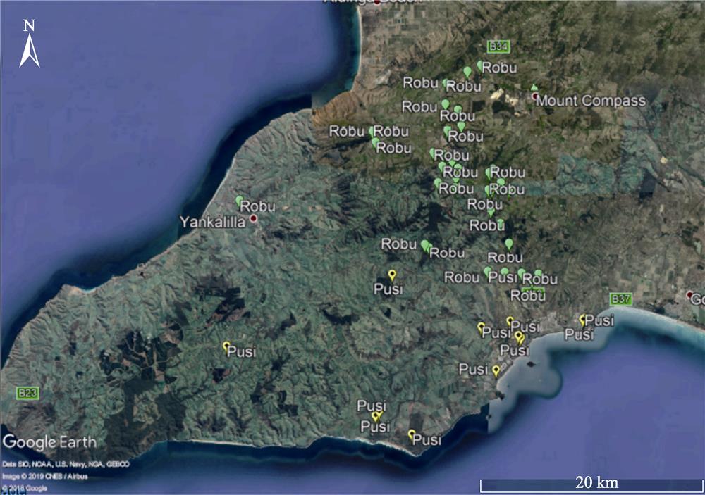
    Figure 3.Zoomed in to a section of Fig. 2 of the main concentration of Allocasuarina robusta on the Fleurieu Peninsula

    Note: Robu = Allocasuarina robusta

    A zoomed-in section of Fig. 2 showing the dates collected for Allocasuarina robusta on the Fleurieu Peninsula

    Figure 4.A zoomed-in section of Fig. 2 showing the dates collected for Allocasuarina robusta on the Fleurieu Peninsula

    Note: Map created in Open Source ESRI GIS.

    Edited version of Fig. 1 showing an enlarged portion of Allocasuarina pusilla near Victor Harbor with the year of collection Note: Map created in Open Source ESRI GIS.

    Figure 5.Edited version of Fig. 1 showing an enlarged portion of Allocasuarina pusilla near Victor Harbor with the year of collection Note: Map created in Open Source ESRI GIS.

    Allocasuarina robusta distribution located in agricultural areas with a unique set of landscape pressures (Ford, 1998).

    Geographical gradients can impact on species morphology, while a revision on Allocasuarina robusta, has occurred using genetics the impact of fragmentation is still unresolved. Some of these studies were not reliant on the use of genetic sequencing to identifying the changes in a species. A study that was conducted by Farrel and Ashton (1978) described how slight, yet persistent morphological variations occurred within the phyllodes and seed characteristics of Acacia melancoxylon. The variation found within the Acacia melancoxylon collected from numerous geographical and community associations was not restricted to a single environment/climatic factor (Farrel and Ashton, 1978). Farrel and Ashton (1978) concluded that the causation of the changes within phyllodes and how they relate to physiological processes is still unknown. Species which use a combination of clonal and seed recruitment can use the process to compensate for when seasons are unfavourable for seed recruitment or for taking advantage of disturbance events (Farrel and Ashton 1978, Callister et al. 2018).

    To increase genetic diversity, Quarmby (2011) took remedial action by reinforcing populations with seedlings from other metapopulations. Quarmby (2011) remedial actions were using the best intentions but not knowing at a genetic level how each fragment of Allocasuarina robusta is related could be masking evolutionary processes within the Allocasuarina robusta towards adapting to a specific microhabitat. The concept of microhabitats can lead to specialisation of a species is not seen as unusual in the opinion of Gogol-Prokurat (2011) who cites as an example the endemism found in the California Floristic Provenance. The concept of reinforcing populations and translocating other members of Allocasuarina robusta can have negative connotations, but this is not always the case. Instead, the process of translocation should be one which can bolster the survival of species as numerous examples of successful translocation has occurred in the past, e.g. Persoonia pauciflora (Emery et al. 2018), and Cassinia rugata (Collier and Garnett, 2018). The unique aspect of Emery et al. (2018) translocation of Persoonia pauciflora was the initial results indicated the species was surviving, but the real test as Emery et al. (2018) identified is the demonstration of population recruitment. Like Emery et al. (2018) the translocation program, undertaken by Quarmby (2011) replicated the aspects of involving the community to provide ownership and respect towards a threatened species and its habitat.

    To highlight the importance of understanding a species breeding system would be as Collier and Garnett (2018) describes the difference which can occur in sowing seeds by collecting seeds leading to the demise of the parent plant. Collier and Garnett (2018) acknowledge sowing seeds and the relationship seeds have with fire is not well understood. The size of populations can increase the risks posed to extinction either at various scales locally, regional or statewide (Morgan, 1999). The lack of knowledge we have of a species breeding system or the genetic relationships within a population compared to other populations is seen as hesitant when practices used by Emery et al. (2018) and Collier and Garnett (2018) demonstrates successful species translocation. The significant risk posed in a translocation program like the one undertaken by Collier and Garnett (2018) in the opinion of Morgan (1999) can result in transplant shock by physically removing germinated individuals from one location to another resulting in the death of the seedling/sapling.

    6 Moving forward

    As a society, the process of classifying threatened species can have significant implications. In the case of Allocasuarina robusta pressure is mounting on the species through not only changes in land use but through urban encroachment. The interaction within and between Allocasuarina robusta populations could be just as critical as the anthropogenic factors that are impacting on the species. The critical question with a species recognised as threatened but needing protection is how to make these populations self-sustaining. The process can sometimes involve understanding the species from multiple perspectives in the case of Allocasuarina robusta through understanding the relationship with biogeography is one aspect. While this may be useful for a translocation program, it does not resolve the critical aspects needed for sustaining a population being the breeding system. Examining the breeding systems in isolation without considering what possible effects fragmentation has on adaption may not lead to a desirable outcome. Instead, we should be investigating the breeding system and how fragmentation has impacted on these populations as a whole instead of as two different subjects.

    The breeding systems in the context of fragmentation can provide a vital process into defining the needs to protect a species/population or better manage an existing population of Allocasuarina robusta. The critical aspect to the breeding system is, to begin with, the seed as this is where the future populations of Allocasuarina robusta will form. Understanding the conditions that would encourage seed germination can then lead to understanding the relationships between metapopulations. The immediate next step would be to undertake a pilot study examining the seed characteristics/germination requirements, which are critical for a self-sustaining population. As with any conservation biology project, limited resources can mean a pilot study can facilitate identifying the critical areas which would form a much larger study.

    References

    [1] Bardsley DK, Sweeney SM. Guiding climate change adaptation within vulnerable natural resource management systems. Environmental Management, 45, 1127-1141(2010).

    [2] Bardsley DK, WeberD, Robinson GM et al. Wildfire risk, biodiversity and peri-urban planning in the Mt Lofty Ranges, South Australia. Applied Geography, 63, 155-165(2015).

    [3] BickfordS, GellP. Holocene vegetation change, Aboriginal wetland use and the impact of European settlement on the Fleurieu Peninsula, South Australia. The Holocene, 15, 200-215(2005).

    [4] BickfordS, GellP, Hancock GJ. Wetland and terrestrial vegetation change since European settlement on the Fleurieu Peninsula, South Australia. The Holocene, 18, 425-436(2008).

    [5] BickfordS, MackeyB. Reconstructing pre-impact vegetation cover in modified landscapes using environmental modelling, historical surveys and remnant vegetation data: A case study in the Fleurieu Peninsula, South Australia. Journal of Biogeography, 31, 787-805(2004).

    [6] Bradstock RA, Keith DA, Auld TD. 1995. Fire conservation: Imperatives and constraints on managing for diversity. In: Bradstock R A, Auld T D, Keith D A, et al. Conservation biodiversity: Threats and solutions. Chipping Borton: Surrey Beatty and Sons:, 323-333.

    [7] Callister KE, Florentine SK, Westbrooke ME. An investigation of the soil seedbank and seed germination of perennial species in Belah (. Casuarina pauper) woodlands in north-west Victoria. Australian Journal of Botany, 66, 202-212(2018).

    [8] ClarkeB, RuddD, HarveyN. The ‘sea change’ phenomenon in South Australia. South Australia Geographical Journal, 107, 69-85(2008).

    [9] CollierP, GarnettR. Threatened plant translocation case study:. Wrinkled Dollybush), Asteraceae. Australasian Plant Conservation, 26, 21-24(2018).

    [10] Corlett RT. Plant diversity in a changing world: Status, trends, and conservation needs. Plant Divers, 38, 10-16(2016).

    [11] Crossman ND, Bryan BA, Cooke DA. An invasive plant and climate change threat index for weed risk management: Integrating habitat distribution pattern and dispersal process. Ecological Indicators, 11, 183-198(2011).

    [12] Dilcher DL, Christophel DC, Bhagwandin HO et al. Evolution of the. Casuarinaceae: Morphological comparisons of some extant species. American Journal of Botany, 77, 338-355(1990).

    [13] Dolan RW, Moore ME, Stephens JD. Documenting effects of urbanization on flora using herbarium records. Journal of Ecology, 99, 1055-1062(2011).

    [14] Elzinga CL, Salzer DW, Willoughby JW. Measuring & monitoring plant populations. Denver Colorado: Bureau of. Land Management National Business Center.(1998).

    [15] Emery NJ, HillierP, Offord CA. Threatened plant translocation case study:. North Rothbury Persoonia), Proteaceae. Australasian Plant Conservation, 26, 18-21(2018).

    [16] Farrel TP, Ashton DH. Population studies on. Acacia melanoxylon R. Br. I. variation in seed and vegetative characteristics. Australian Journal of Botany, 26, 365-379(1978).

    [17] FordT. Population change in Adelaide’s Peri-urban region: Patterns, causes and implication. Master diss., University of. Adelaide.(1998).

    [18] Fusco DA, McDowell MC, Prideaux GJ. Late-Holocene mammal fauna from southern Australia reveals rapid species declines post-European settlement: Implications for conservation biology. The Holocene, 26, 699-708(2015).

    [19] Gaston KJ. Valuing common species. Science, 327, 154-155(2010).

    [20] Given DR, Norton DA. A multivariate approach to assessing threat and for priority setting in threatened species conservation. Biological Conservation, 64, 57-66(1993).

    [21] Gogol-ProkuratM. Predicting habitat suitability for rare plants at local spatial scales using a species distribution model. Ecological Applications, 21, 33-47(2011).

    [22] Guerin GR. Monitoring diversity and tree demography in vegetation communities of the Mount Lofty - Flinders Ranges. The South Australian Naturalist, 91, 56-67(2017).

    [23] Guerin GR, BiffinE, BaruchZ et al. Identifying Centres of Plant Biodiversity in South Australia. Plos One, 11, e0144779(2016).

    [24] HansenM.J, Clevenger AP. The influence of disturbance and habitat on the presence of non-native plant species along transport corridors. Biological Conservation, 125, 249-259(2005).

    [25] Harding CL. 4.3 Threatening processes and management issues. Wetland Inventory for the Fleurieu Peninsula. Harding C L. Adelaide South Australia, National Action Plan for Salinity and Water Quality / Department for Environment &. Heritage.(2005).

    [26] Heywooda VH, Iriondo JM. Plant conservation: Old problems, new perspectives. Biological Conservation, 113, 321-335(2003).

    [27] JessopJ, Black JM, Toelken HR. Flora of South Australia: Lycopodiaceae-Rosaceae. South Australian Government Printing Division.(1986).

    [28] Johnson L AS. Notes on. Casuarinaceae II. Journal of Adelaide Botanic Gardens, 6, 73-87(1982).

    [29] KeanJ, BarlowN. Exploring rarity using a general model for distribution and abundance. The American Naturalist, 163, 407-416(2004).

    [30] Kricsfalusy VV, TrevisanN. Prioritizing regionally rare plant species for conservation using herbarium data. Biodiversity and Conservation, 23, 39-61(2013).

    [31] Ladiges PY, Bayly MJ, NelsonG. Searching for ancestral areas and artifactual centers of origin in biogeography: With comment on east-west patterns across southern Australia. Systematic Biology, 61, 703-708(2012).

    [32] LindenmayerD. Small patches make critical contributions to biodiversity conservation. Proceedings of the National Academy of Sciences, 116, 717-719(2019).

    [33] Lopez Ortiz MJ, MarceyT, Lucash MS et al. Post-fire management affects species composition but not Douglas-fir regeneration in the Klamath Mountains. Forest Ecology and Management, 432, 1030-1040(2019).

    [34] LothianA, HarrisC. Clearance of native vegetation in the Mount Lofty Ranges 1945-68. South Australian Geographical Journal, 113, 29-42(2014).

    [35] Lunt ID, Spooner PG. Using historical ecology to understand patterns of biodiversity in fragmented agricultural landscapes. Journal of Biogeography, 32, 1859-1873(2005).

    [36] Master LL. Assessing threats and setting priorities for conservation. Conservation Biology, 5, 559-563(1991).

    [37] McIntyreS, LavorelS. Predicting richness of native, rare, and exotic plants in response to habitat and disturbance variables across a variegated landscape. Conservation Biology, 8, 521-531(1994).

    [38] MorganJ. Have tube stock plantings successfully established populations of rare grassland species into reintroduction sites in western Victoria?. Biological Conservation, 89, 235-243(1999).

    [39] Morrison DA. Effects of fire intensity on plant species composition of sandstone communities in the Sydney region. Austral Ecology, 27, 433-441(2002).

    [40] MotzkinG, WilsonP, Foster DR et al. Vegetation patterns in heterogeneous landscapes: The importance of history and environment. Journal of Vegetation Science, 10, 903-920(1999).

    [41] NualartN, Ibá?ezN, SorianoI et al. Assessing the relevance of herbarium collections as tools for conservation biology. The Botanical Review, 83, 303-325(2017).

    [42] Ottewell KM, Bickerton DC, ByrneM et al. Bridging the gap: A genetic assessment framework for population-level threatened plant conservation prioritisation and decision-making. Diversity and Distributions, 22, 174-188(2016).

    [43] Pannell JR, Myerscough PJ. Canopy-stored seed banks of. Allocasuarina distyla and A. nana in relation to time since fire. Australian Journal of Botany, 41, 1-9(1993).

    [44] PatonP, CromptonJ. Birds of the hundred of Encounter Bay listed by John W Crompton from 1909 to 1925. South Australian Ornithologist, 39, 18-35(2013).

    [45] Pilgrim ES, Crawley MJ, DolphinK. Patterns of rarity in the native British flora. Biological Conservation, 120, 161-170(2004).

    [46] Pressey RL, Nicholls AO. Efficiency in conservation evaluation: Scoring versus iterative approaches. Biological Conservation, 50, 199-218(1989).

    [47] QuarmbyJ. Action plan for mount compass oak--Bush (Allocasuarina robusta). Department of Environment and Natural Resources, Stirling (Cleland Conservation Park), Adelaide & Mount Lofty Ranges Natural Resource Management Board.(2011).

    [48] ReuterD. The South Australian superphosphate story - Part I. Agricultural Science, 1, 23-33(2012).

    [49] Rivers MC, TaylorL, Brummitt NA et al. How many herbarium specimens are needed to detect threatened species?. Biological Conservation, 144, 2541-2547(2011).

    [50] Roxburgh SH, SheaK, Wilson JB. The intermediate disturbance hypothesis: Patch dynamics and mechanisms of species coexistence. Ecology, 85, 359-371(2004).

    [51] SalzerD, SalafskyN. Allocating Resources Between Taking Action, Assessing Status, and Measuring Effectiveness of Conservation Actions. Natural Areas Journal, 26, 310-316(2006).

    [52] Spooner PG, Lunt ID. The influence of land-use history on roadside conservation values in an Australian agricultural landscape. Australian Journal of Botany, 52, 445-458(2004).

    [53] Steane DA, Wilson KL, Hill RS. Using matK sequence data to unravel the phylogeny of Casuarinaceae. Molecular Phylogenetics and Evolution, 28, 47-59(2003).

    [54] Stenhouse RN. Assessing disturbance and vegetation condition in urban bushlands. Australasian Journal of Environmental Management, 12, 16-26(2005).

    [55] Swamy B GL. A contribution to the life history of Casuarina. Proceedings of the American Academy of Arts and Sciences, 77(1): 3-, 27, 29-32(1948).

    [56] Swetnam TW, Allen CD, Betancourt JL. Applied historical ecology: Using the past to manage for the future. Ecological Applications, 9, 1189-1206(1999).

    [57] TurnbullJ. Historical GIS - Examples from the Creswick Goldfields. Geospatial science research,. CEUR workshop proceedings, 2, 37-46(2012).

    [58] ViolleC, ThuillerW, MouquetN et al. Functional rarity: The ecology of outliers. Trends of Ecology and Evolution, 32, 356-367(2017).

    [59] Williams JN, SeoC, ThorneJ et al. Using species distribution models to predict new occurrences for rare plants. Diversity and Distributions, 15, 565-576(2009).

    [60] Willis CG, Ellwood ER, Primack RB et al. Old plants, new tricks: Phenological research using herbarium specimens. Trends of Ecology and Evolution, 32, 531-546(2017).

    [61] WillsonA, BignallJ. 2009. Regional recovery plan for threatened species and ecological communities of the Adelaide and the Mount Lofty Ranges South Australia. South Australian Government Department for Environment and Heritage.. http://www.environment.gov.au/biodiversity

    [62] WilsonK. Johnson L A S. 1989. Casuarinaceae. In: Robertson R et al., eds. Flora of Australia, George A S. Canberra ACT Australia, Australian Government Printing Service:, 3, 100-174.

    W Pearson MATTHEW. A Case Study of Allocasuarina robusta Recovery Using History and Biogeography to Identify Future Priorities[J]. Journal of Resources and Ecology, 2020, 11(2): 171
    Download Citation